Foundation cloud atlas classification method based on spatial pyramid random mapping

A space pyramid and ground-based cloud image technology, applied in the field of image processing, can solve problems such as not taking into account the spatial information of the ground-based cloud image and not being able to represent the ground-based cloud image well

Inactive Publication Date: 2014-02-26
康江科技(北京)有限责任公司
View PDF3 Cites 8 Cited by
  • Summary
  • Abstract
  • Description
  • Claims
  • Application Information

AI Technical Summary

Problems solved by technology

The above detection methods all extract simple texture features from the cloud image, without taking into account the spatial information in the ground-based cloud image, and obviously cannot represent the information in the ground-based cloud image well.

Method used


Image

  • Foundation cloud atlas classification method based on spatial pyramid random mapping
  • Foundation cloud atlas classification method based on spatial pyramid random mapping

Examples


Embodiment Construction

[0025] In order to make the object, technical solution and advantages of the present invention clearer, the present invention will be described in further detail below in conjunction with specific embodiments and with reference to the accompanying drawings.

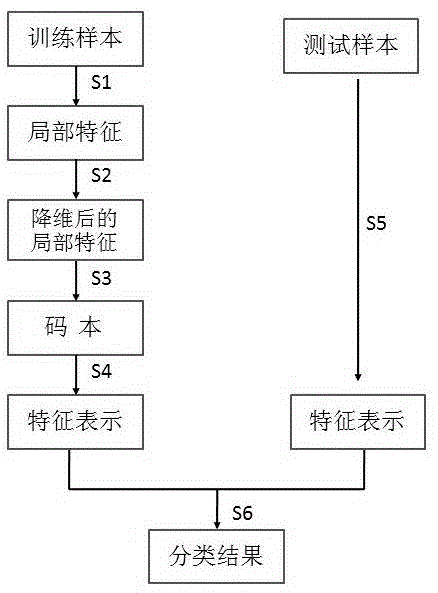
[0026] figure 1 It is a flow chart of a ground-based cloud image classification method based on the random mapping of the space pyramid proposed by the present invention, such as figure 1 As shown, the method includes the following steps:

[0027] Step 1, for each training ground-based cloud image sample, extract its local features according to the dense sampling method, here directly use the intensity value of the local image as the local feature;

[0028] Step 2, use random mapping to reduce the dimensionality of each local feature, and map the original high-dimensional feature set into a low-dimensional subspace, the formula is as follows:

[0029] (1)

[0030] in x means original N dimen...


PUM


Abstract

The invention discloses a foundation cloud atlas classification method based on spatial pyramid random mapping. The method comprises the following steps of firstly, extracting local features from each training foundation cloud atlas sample in a denseness sampling manner; then, carrying out dimensionality reduction on each local feature by applying random mapping, and mapping an original high-dimensionality feature set to a low-dimensionality subspace; then, clustering features which are subjected to dimensionality reduction in the low-dimensionality subspace, so as to obtain a codebook; then, dividing a sample image into different areas according to a spatial pyramid model, obtaining area features of the different areas according to the codebook, combining the area features, and taking the combined area features as final feature representation of the sample image; finally, obtaining a classification result of a tested foundation cloud atlas by applying a support vector machine classifier. According to the method, spatial information of the image can be obtained through applying the spatial pyramid model, so that information in the cloud atlas can be better represented; meanwhile, the local features of the image are subjected to dimensionality reduction by adopting random mapping, so that the efficiency of a foundation cloud atlas classification system can be increased, the time expense is reduced, and the dimensionality disaster can be avoided.

Description

technical field [0001] The invention belongs to the technical field of image processing, in particular to a ground-based cloud image classification method based on random mapping of space pyramids. Background technique [0002] Clouds are the external manifestations of thermodynamic and dynamic processes in the atmosphere. Their generation and evolution are one of the concrete manifestations of the intricate physical processes that occur in the atmosphere. They not only reflect the movement, stability, and water vapor conditions of the atmosphere at that time, but also can predict the future. The trend of weather changes over a certain period of time. Therefore, cloud observation is an important part of meteorological observation, and accurate acquisition of cloud information is of great significance to weather forecasting, national economy, military support and many other fields. At present, cloud detection is mainly done through ground-based observation and satellite remo...

Claims


Application Information

Patent Timeline
Patent Type & Authority Applications(China)
IPC IPC(8): G06K9/62
Inventor 不公告发明人
Owner 康江科技(北京)有限责任公司
Why Eureka
Try Eureka