A digital law enforcement subsystem based on gis and its working method

A working method and subsystem technology, applied in the field of information communication, can solve problems such as low processing efficiency, poor compatibility, and low development efficiency, and achieve the effects of high resource integration, improved case handling efficiency, and improved accuracy

Active Publication Date: 2018-10-30
TAIHUA WISDOM IND GRP CO LTD
View PDF2 Cites 0 Cited by
  • Summary
  • Abstract
  • Description
  • Claims
  • Application Information

AI Technical Summary

Problems solved by technology

[0003] However, at present, the smart urban management digital law enforcement system lacks a unified processing structure and process. Originally, the code development did not pay attention to the overall consideration. Although it can also solve the internal business processing of the law enforcement bureau, there are the following problems:
[0004] 1. Each department and brigade of the Law Enforcement Bureau handles the business of its own department. Simple cases and general procedural cases cannot form electronic files, and automatic circulation, filing and summary cannot be realized. Statistics and assessment data are manually calculated, and the maintenance workload is heavy and the accuracy rate is not good. Guarantee; illegal vehicle capture, letters and visits complaints, and inspection services cannot be approved online, and the processing efficiency is low. Due to the above problems, it is difficult to carry out unified coordination and control of the law enforcement system
[0005] 2. The level of intelligence and informatization is low: Currently, cases can only be recorded manually, and cannot be reported in real time. The approval of leaders requires paper-based face-to-face confirmation; manual recording of problems found in vehicle capture and inspection management is time-consuming and laborious
[0006] 3. Poor integration of resources, low development efficiency, and poor compatibility: When the businesses of various brigades and departments overlap, they cannot be processed quickly. They are often for the purpose of completing the business development code of the department, and cannot be coordinated

Method used


Image

  • A digital law enforcement subsystem based on gis and its working method
  • A digital law enforcement subsystem based on gis and its working method

Examples


Embodiment Construction

[0048] The present invention is described in detail below in conjunction with accompanying drawing and specific embodiment:

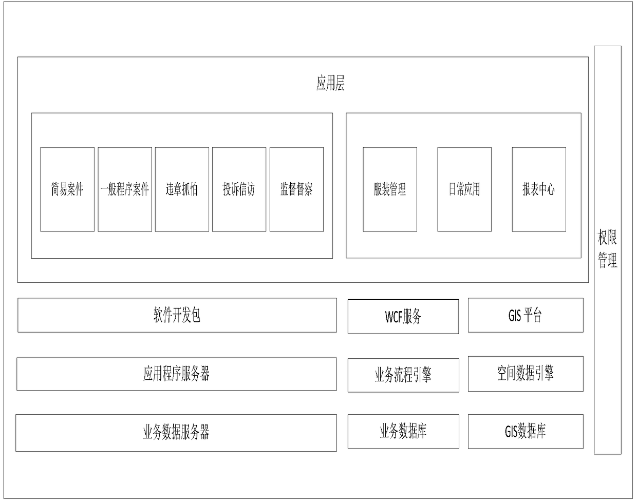
[0049] The composition frame diagram of the digital law enforcement subsystem based on GIS of the present invention is as follows figure 1 As shown, it specifically includes: regulatory data wireless collection equipment, application layer, storage layer, geographic information system platform, spatial data engine, and authority management module;

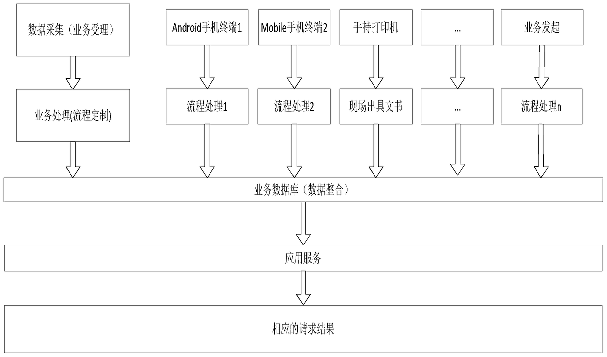
[0050] Supervision data wireless collection equipment: used to collect text, pictures, audio and video information representing case information, and transmit the information to the terminal equipment at the application layer;

[0051] Application layer: the working layer that provides users with business processing and interactive services, used to receive data information uploaded by terminal equipment and process the information, and realize violation capture, petition complaints, supervision and inspecti...


PUM


Abstract

The present invention discloses a GIS based digital law enforcement subsystem and an operation method thereof. The system comprises a monitoring data wireless acquisition device, an application layer, a storage layer, a geographical information system platform, a spatial data engine and a permission management module. The application layer is a working layer that provides service processing and interactive services for a user, and is used for receiving data information uploaded by a terminal device, performing processing on the information, implementing real-time monitoring and unified scheduling of violation captured data, letter complaint data, monitoring supervision data and apparel monitoring data, completing data storage, updating, query, positioning and report processing and feeding back relative information to the terminal device. The digital law enforcement system disclosed by the present invention adopts a manner that an application server uniformly monitors various service procedures; and a corresponding procedure customized in the application server can be directly called and unobstructed flow is ensured by means of a seamless interface during service crossing, so that the digital law enforcement system which is quick and convenient to develop and unified for maintenance and has a high resource integration is formed.

Description

technical field [0001] The invention relates to the technical field of information communication, in particular to a GIS-based digital law enforcement subsystem and its working method. Background technique [0002] The digital law enforcement system is a tool for the Urban Management Administrative Law Enforcement Bureau to handle legal cases, handle letters and visits and complaints, carry out internal inspections, and understand the city's urban management status. It is an important part of the digital urban management information system. The purpose of establishing a digital law enforcement system is: Cases, capturing illegal vehicles, handling petitions and complaints, inspecting and assessing law enforcement teams, and counting case results, etc., have played a significant role in quickly handling cases for law enforcement officers and improving their own team building. [0003] However, at present, the smart urban management digital law enforcement system lacks a unifi...

Claims


Application Information

Patent Timeline
Patent Type & Authority Patents(China)
IPC IPC(8): G06F17/30G06Q50/26
Inventor 周永利谭文时念武马述杰董吉臣刘福辉
Owner TAIHUA WISDOM IND GRP CO LTD
Why Eureka
Try Eureka