Polarization SAR terrain classification method based on deep learning and distance metric learning

A metric learning and deep learning technology, applied in the field of image classification and image processing, can solve the problems of high time complexity, limited classification accuracy, slow processing speed, etc., to achieve low time complexity, overcome low classification accuracy, improve classification The effect of precision

Inactive Publication Date: 2016-08-03
XIDIAN UNIV
View PDF6 Cites 15 Cited by
  • Summary
  • Abstract
  • Description
  • Claims
  • Application Information

AI Technical Summary

Problems solved by technology

However, the disadvantages of this method are, first, for the face database it uses, the classifier is directly trained with training samples, and the image cannot be represented hierarchically
This method first performs Cloude decomposition on each pixel of the image, and then divides the image initially according to the entropy H and scattering angle α obtained from the decomposition, and then performs K-wishart iteration on the division results, which can improve the classification accuracy to a certain e

Method used


Image

  • Polarization SAR terrain classification method based on deep learning and distance metric learning
  • Polarization SAR terrain classification method based on deep learning and distance metric learning
  • Polarization SAR terrain classification method based on deep learning and distance metric learning

Examples


Example Embodiment

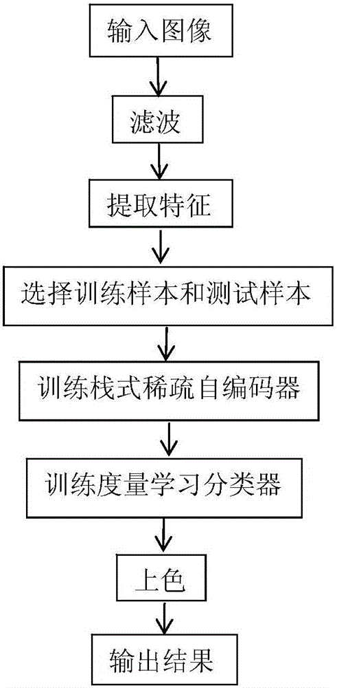
[0041] The present invention will be further described below in conjunction with the drawings.

[0042] Reference attached figure 1 The specific steps of the present invention are as follows:
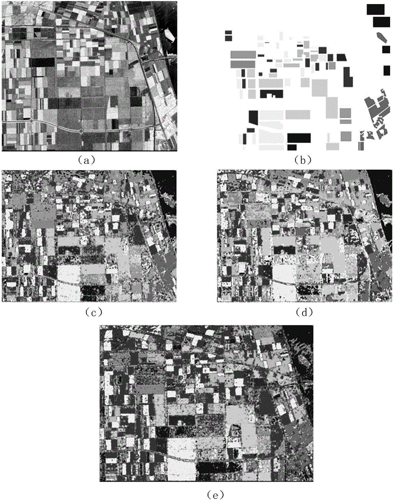
[0043] Step 1. Input the polarization SAR image to be classified.

[0044] Step 2. Filtering.

[0045] The Lee filter method with a filter window size of 7×7 is used to filter the polarized SAR image to be classified, remove the coherent speckle noise, and obtain the filtered polarized SAR image.

[0046] Step 3. Extract features.

[0047] (1) Calculate the two scattering parameters of scattering entropy and scattering angle;

[0048] The first step is to calculate the scattering entropy of the polarized SAR image according to the following formula:

[0049] H = X i = 1 3 - P i log 3 ( P i )

[0050] Among them, H represents the scattering entropy of the polarized SAR image, the value range of H is: 0≤H≤1, Σ represents the summation operation, i represe...


PUM


Abstract

The invention discloses a polarization SAR terrain classification method based on deep learning and distance metric learning. The polarization SAR terrain classification method comprises the realization steps that (1) images are inputted; (2) filtering is performed; (3) features are extracted; (4) training samples and test samples are selected; (5) a stacked sparse auto-encoder is trained so that the deep features of a training sample set and the deep features of a test sample set are obtained; (6) a distance metric learning classifier is trained so that a classification result is obtained; (7) the classification result is colored; and (8) the colored classification result graph is outputted. The images are classified by using the polarization SAR terrain classification method based on deep learning and distance metric learning so that feature extraction is relatively comprehensive and reasonable, the classification result is more consistent with real terrains, time complexity is reduced and classification precision is enhanced.

Description

technical field [0001] The present invention belongs to the technical field of image processing, and further relates to a PolarimetricSyntheticApertureRadar (PolSAR) feature classification method based on deep learning and metric learning in the technical field of image classification. The invention can be used for feature extraction and object classification of polarimetric SAR images. Background technique [0002] Polarimetric SAR image classification is an important step in the image interpretation process, and it is also an important research direction of polarimetric SAR image processing. Polarization SAR can obtain richer surface feature information than traditional single-polarization SAR. In the face of these large-scale and complex data, it is unrealistic for traditional methods to quickly process them and achieve high classification accuracy. , so it is urgent to propose some classification methods that can handle large data and have low time complexity. [0003]...

Claims


Application Information

Patent Timeline
IPC IPC(8): G06K9/62G06K9/46
CPCG06V10/462G06F18/2411
Inventor 焦李成马文萍王明洁马晶晶侯彪杨淑媛刘红英冯婕王蓉芳
Owner XIDIAN UNIV
Why Eureka
Try Eureka