A mobile cellular network and satellite navigation system combined satellite signal blind area positioning method

A technology of satellite navigation system and mobile cellular network, applied in the direction of satellite radio beacon positioning system, radio wave measurement system, measurement device, etc.

Inactive Publication Date: 2018-06-08
DALIAN UNIV OF TECH
View PDF7 Cites 0 Cited by
  • Summary
  • Abstract
  • Description
  • Claims
  • Application Information

AI Technical Summary

Problems solved by technology

However, for environments with incomplete infrastructure, the deployment of satellite repeaters will encounter great challenges

Method used


Image

  • A mobile cellular network and satellite navigation system combined satellite signal blind area positioning method
  • A mobile cellular network and satellite navigation system combined satellite signal blind area positioning method
  • A mobile cellular network and satellite navigation system combined satellite signal blind area positioning method

Examples


Embodiment Construction

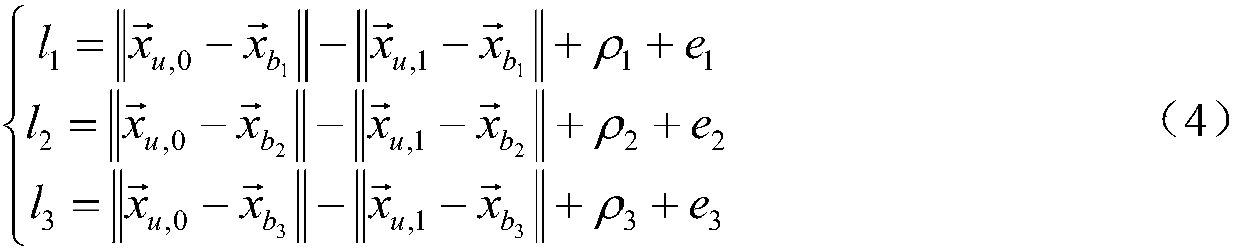
[0050] The first positioning method:

[0051] Firstly, the signal forwarding processing time error is eliminated. recorded at time t k The signal measured by the receiver is from the satellite s i via base station b j The time elapsed for forwarding to the receiver is then there is

[0052]

[0053] in, is the signal from the satellite s i to base station b j time; is the signal from base station b j Time to receiver; δt c is the receiver clock difference; is the signal from the satellite s i to base station b j to the propagation error experienced by the receiver; It is the time it takes for the signal to arrive at the base station antenna, be processed by the base station, and then be transmitted from the base station antenna; represents other measurement errors.

[0054] The difference operation is performed on the signal propagation time from the same satellite and forwarded to the receiver by the same base station but measured at different times, a...


PUM


Abstract

The invention belongs to the field of electronic communication and automatic control, and relates to a method for achieving the positioning of a receiver in a satellite signal blind area through combining a mobile cellular network and a satellite navigation system. The method comprises the steps that the receiver employs two different methods for independently calculating the position coordinates firstly through employing a satellite signal transmitted by a base station: one method is that the receiver deduces the position coordinates at a next moment based on a positioning result at a former moment, and the other method is that the receiver measures the pseudo-distance between the base station and the receiver through employing the satellite signal, and then calculates the position through employing a triangulation location principle; afterwards, the receiver combines the positioning results, obtained through the above two methods, as an observation value, and carries out the filtering of the results through employing a Kalman filtering algorithm, so as to determine the final position coordinates of the a user. The method is low in arrangement cost in actual use, is easy to install, and can obtain higher positioning precision.

Description

technical field [0001] The invention belongs to the fields of electronics, communication and automatic control, and relates to user positioning based on navigation satellites, in particular to user positioning in blind areas of navigation satellite signals. Background technique [0002] In blind areas of navigation satellite signals, such as inside buildings or tunnels and under viaducts, user receivers generally cannot directly obtain satellite signals, that is, they cannot directly use navigation satellite signals to calculate positions. In this case, if it is still necessary to use satellite signals to achieve positioning, it is necessary to amplify and forward the satellite signals through other devices located in areas with good satellite signals so that users in the blind area can receive effective satellite signals to achieve positioning, such as for indoor Satellite signal repeater forwarding technology used for positioning, etc. However, for environments with incom...

Claims


Application Information

Patent Timeline
Patent Type & Authority Patents(China)
IPC IPC(8): G01S19/46
CPCG01S19/46G01S19/11G01S19/12
Inventor 李秀魁
Owner DALIAN UNIV OF TECH
Why Eureka
Try Eureka