Method for distinguishing coal pile and coal shale area in coal mining area in remote sensing image

A technology for remote sensing images and coal gangue, applied in the field of remote sensing image processing, can solve the problems of low availability of shape features, irregular shape features, and high misclassification rate.

Inactive Publication Date: 2017-10-20
UNIV OF ELECTRONICS SCI & TECH OF CHINA
View PDF5 Cites 6 Cited by
  • Summary
  • Abstract
  • Description
  • Claims
  • Application Information

AI Technical Summary

Problems solved by technology

[0006] In remote sensing images, because the coal piles and gangue areas have similar spectral characteristics and irregular shape characteristics, the spectral characteristics of the image only have a high misclassification rate, and the availability of shape characteristics is not large, so there is no better one. A method that can distinguish coal piles and gangue areas in remote sensing images

Method used


Image

  • Method for distinguishing coal pile and coal shale area in coal mining area in remote sensing image
  • Method for distinguishing coal pile and coal shale area in coal mining area in remote sensing image
  • Method for distinguishing coal pile and coal shale area in coal mining area in remote sensing image

Examples


Embodiment Construction

[0044] In order to make the purpose, technical solution and advantages of the present invention clearer, the present invention will be further described in detail below in conjunction with the implementation methods and accompanying drawings.

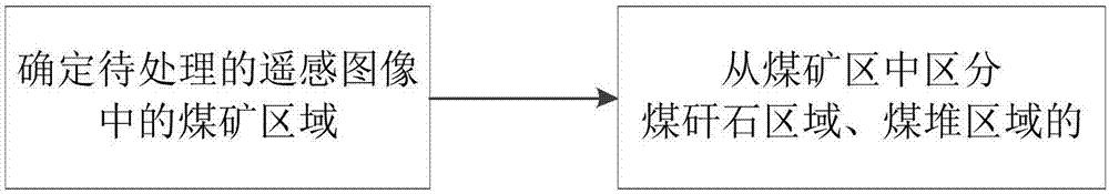
[0045] see figure 1 A method for distinguishing coal piles and coal gangue regions in a coal mining area in a remote sensing image of the present invention, comprising the following steps:

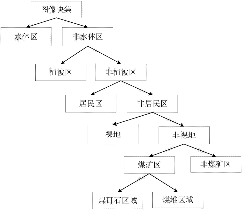
[0046] S1: Determine the coal mining area in the remote sensing image to be processed:

[0047] First, the remote sensing image to be processed is segmented by the watershed method to obtain the initial segmented area, and then the FNEA method (fractal network evolution method) is used to merge the initial segmented area to obtain the image block of the remote sensing image to be processed; and then use the decision tree for each image block Judgment method, first classify the water body area / non-water body area, then classify the vegetation area / n...


PUM


Abstract

The present invention discloses a method for distinguishing a coal pile and a coal shale area in a coal mining area in a remote sensing image. The method concretely comprises: performing area segmentation of a high-resolution remote sensing image, and obtaining an irregular object; employing a decision tree, and performing classification of a water body area / a non-water body area, a vegetation area / a non-vegetation area, a residential area / a non-residential area, a naked area / a non-naked area and a coal area / non-coal area for the irregular object; and employing an LBP (Local Binary Patterns) operator to extract textural features to distinguish the coal pile area and the coal shale area from the irregular object classified to the coal mining area. On the basis of combination of the decision tree, the classification step by step is performed, a preliminary decision area is provided for the coal mining area, the K-T transformation is employed to effectively extract the coal mining area, and the LBP texture operator is employed to perform effective distinguishing of the coal pile and the coal shale area in the coal mining area.

Description

technical field [0001] The invention relates to the field of remote sensing image processing, in particular to a remote sensing image classification method for feature extraction Background technique [0002] Since the end of the 20th century, the information extraction technology for object-oriented analysis has been continuously developed, and object-oriented classification has gradually become the mainstream of high-resolution remote sensing image analysis. The basic idea of ​​the object-oriented classification method is to first segment the remote sensing image, and then extract the features of the segmented image area, and use the extracted features to classify the remote sensing image. [0003] Object features refer to certain attributes extracted based on the information of the object itself without adding any knowledge, including layer values, shapes, textures, layers, and thematic attributes. Among them, layer value, shape, texture and context information are commo...

Claims


Application Information

Patent Timeline
Patent Type & Authority Applications(China)
IPC IPC(8): G06K9/00G06K9/34G06K9/62
CPCG06V20/13G06V10/267G06F18/2411
Inventor 王帅冯家琪赵希胡佃敏朱策
Owner UNIV OF ELECTRONICS SCI & TECH OF CHINA
Why Eureka
Try Eureka