A geometric algebra encoding and representing method of remote sensing image metadata

A remote sensing image and geometric algebra technology, applied in still image data retrieval, still image data indexing, vector format still image data, etc. problem, to achieve the effect of fusion expression and expansion of information dimension space

Active Publication Date: 2019-05-03
南京泛在地理信息产业研究院有限公司 +1
View PDF6 Cites 2 Cited by
  • Summary
  • Abstract
  • Description
  • Claims
  • Application Information

AI Technical Summary

Problems solved by technology

[0004] Purpose of the invention: In order to solve the problem that remote sensing image metadata is difficult to efficiently organize and manage in the prior art, and to overcome the defects that the existing data coding structure cannot perform data hierarchical expression and fusion expression, the purpose of the present invention is to provide a remote sensing image element The geometric algebraic coding and representation method of data realizes the unified organization and fusion expression of the mixed-dimensional information structure in remote sensing image metadata

Method used


Image

  • A geometric algebra encoding and representing method of remote sensing image metadata
  • A geometric algebra encoding and representing method of remote sensing image metadata
  • A geometric algebra encoding and representing method of remote sensing image metadata

Examples


Embodiment Construction

[0016] In order to enable those skilled in the technical field to which the application belongs to understand the application more clearly, the technical solution of the application will be described in detail below through specific embodiments in conjunction with the accompanying drawings.

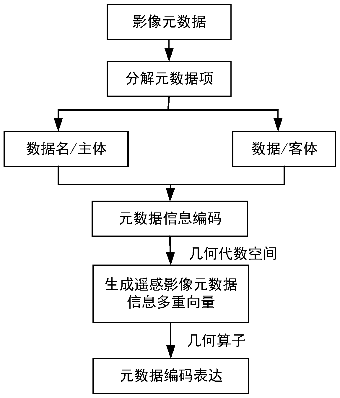
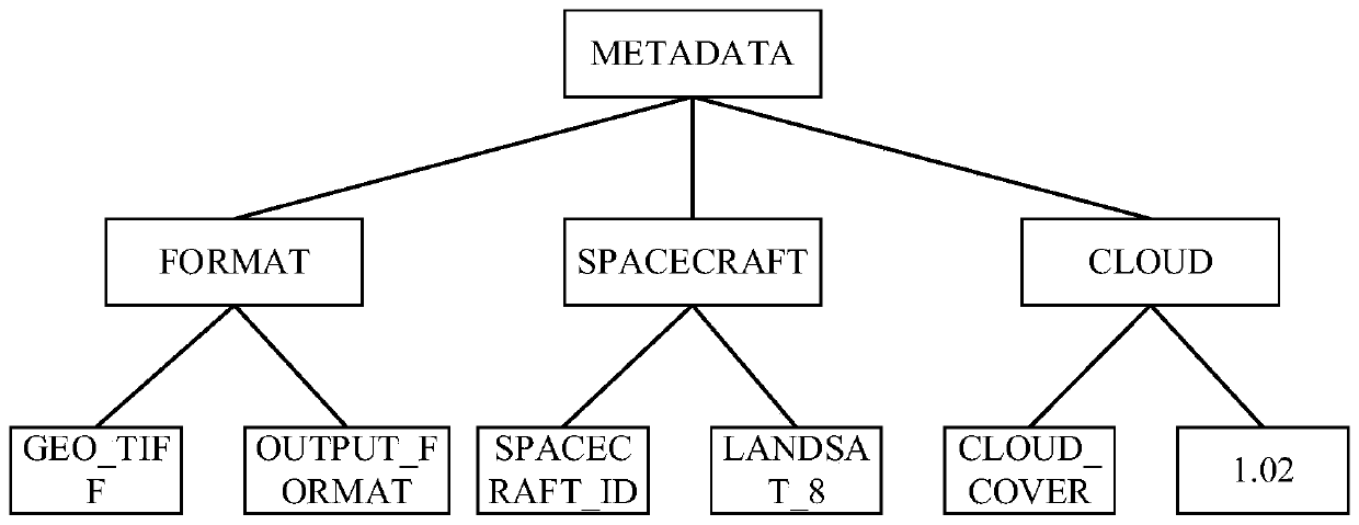
[0017] According to the metadata standard of remote sensing images, the present invention realizes the standardized encoding and fusion expression of metadata information in the geometric algebraic space, such as figure 1 Shown is a remote sensing image metadata encoding method based on geometric algebra. Take the Landsat8 data as an example to specifically illustrate the specific implementation steps of the technical solution of the present invention:

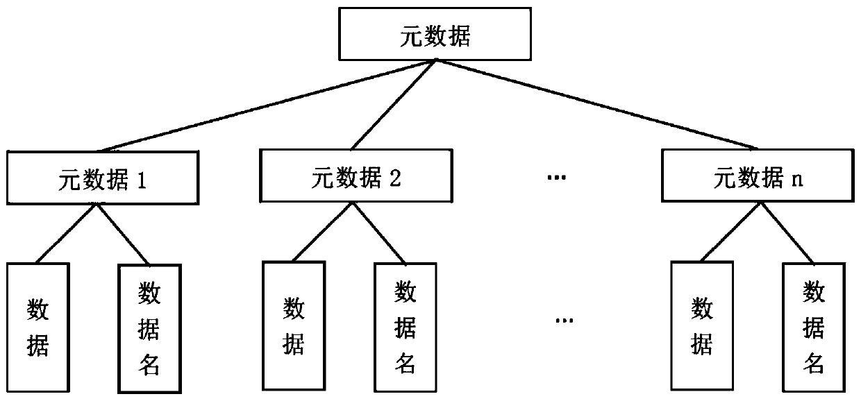
[0018] Step 1: Decomposition of remote sensing image metadata information. According to the geographic information metadata standard, the remote sensing image metadata is layered into multiple metadata items, and the metadata items are f...


PUM


Abstract

The invention discloses a remote sensing image metadata geometric algebraic coding and representation method, which comprises the following steps: layering remote sensing image metadata information into metadata items according to different data types in a geometric algebraic space, further decomposing the metadata items into data names and data structures, and respectively carrying out characterstring and digital coding; Wherein the coded data name and data are respectively expressed as vectors of different dimensions, the vectors of different dimensions are connected by using a geometric product, and different metadata items are connected by using connectors; and generating a multi-vector structure of linear combination between metadata information of different dimension vectors. According to the method, the hierarchical relationship of the information can be described, metadata information association of any different dimension vectors can be effectively supported, and the information dimension space can be expanded; and the geometric algebra pair multi-vector structure can be effectively connected with a mixed dimension object, so that the fusion expression of metadata items can be favorably realized.

Description

technical field [0001] The invention relates to a geographic data processing method, in particular to a geometric algebra encoding and representation method for remote sensing image metadata. Background technique [0002] Remote sensing image metadata is a description of the content, type, representation, spatial reference, management method, and other characteristics of remote sensing images, and is an important means to realize remote sensing data management and sharing. Remote sensing image metadata contains rich data information. At the same time, the continuous acquisition of a large amount of remote sensing data poses new challenges for data storage management and sharing applications. How to quickly and accurately discover, access, acquire and use In order to maximize the value of the required data and maximize its value, it is urgent to organize and manage it effectively. The current research is mainly focused on how to formulate the standard specification of remote...

Claims


Application Information

Patent Timeline
IPC IPC(8): G06F16/29G06F16/51G06F16/56
Inventor 俞肇元张丽莹高鸿胡迪罗文袁林旺胡靖瑶
Owner 南京泛在地理信息产业研究院有限公司
Why Eureka
Try Eureka