Radio-based integrated navigation method

An integrated navigation and radio technology, applied in the field of inertial measurement, can solve the problems of large calculation error, unable to guarantee the accuracy of integrated navigation, affecting the accuracy of position calculation, etc.

Active Publication Date: 2020-05-22
BEIJING AUTOMATION CONTROL EQUIP INST
View PDF4 Cites 3 Cited by
  • Summary
  • Abstract
  • Description
  • Claims
  • Application Information

AI Technical Summary

Problems solved by technology

However, there are certain measurement errors in radio direction finding and ranging, especially direction finding errors will seriously affect the accuracy of position estimation
When the carrie

Method used


Image

  • Radio-based integrated navigation method
  • Radio-based integrated navigation method
  • Radio-based integrated navigation method

Examples


specific Embodiment

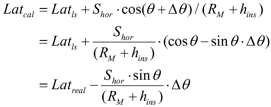
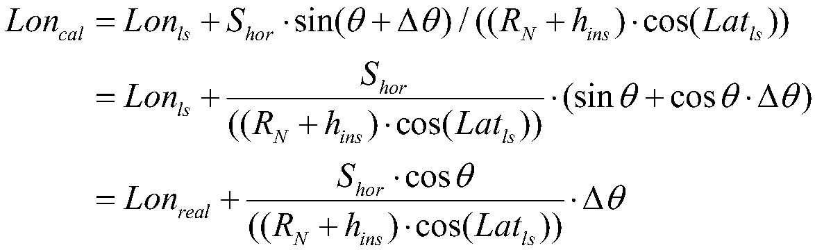
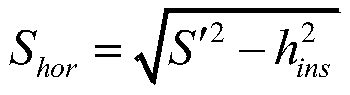
[0105] A radio-based integrated navigation method, including five steps, as follows:

[0106] Step 1. Coordinate system definition

[0107] a) Strapdown inertial navigation system carrier coordinate system (OX b Y b Z b )

[0108] Use the "front-up-right" coordinate system. Select the center of mass of the carrier as the coordinate origin, the OXb axis is positive along the vertical axis of the inertial navigation system and forward, the OYb axis is positive along the vertical axis of the inertial navigation system and upward, and the OZb axis is positive along the horizontal axis of the inertial navigation system and to the right .

[0109] b) Geographic coordinate system (OX g Y g Z g )

[0110] The "north-sky-east" coordinate system is adopted. Select the center of mass of the inertial navigation system as the coordinate origin, OX g The axis is along the geographic north-south direction, and north is positive; OY g The axis is along the celestial direction, and...


PUM


Abstract

The invention belongs to the technical field of inertial measurement, and relates to suppression of inertial navigation position error divergence by using radio direction finding and ranging information and barometric altimeter information. According to the scheme, radio and barometric altimeter error models are established, radio direction finding errors and barometric altimeter errors are estimated through Kalman filtering, and navigation system position and attitude errors are corrected so as to improve the elevation precision of a positioning and orientation system.

Description

technical field [0001] The invention belongs to the technical field of inertial measurement, in particular to a radio-based integrated navigation method. Background technique [0002] The integrated navigation system is one of the core navigation devices of the carrier aircraft, which can provide information such as speed, position, heading and horizontal attitude for various carrier aircraft. When the satellite information is well available, the integrated navigation system uses the satellite information for combination, which can work for a long time and ensure the accuracy of the output information. However, satellite signals are vulnerable to electronic interference and terrain occlusion. When satellite information is unavailable, system errors will diverge over time. Therefore, external information is needed to suppress the divergence of navigation errors. The altitude channel error can be suppressed with the help of external barometric altimeter information, but the b...

Claims


Application Information

Patent Timeline
IPC IPC(8): G01C21/16G01C25/00
CPCG01C21/165G01C25/005
Inventor 钟润伍徐海刚李海军刘冲张维佳高晓波原润裴玉锋孙伟陈更达李志峰
Owner BEIJING AUTOMATION CONTROL EQUIP INST
Why Eureka
Try Eureka