Pseudo-satellite site simulation layout method based on DEM data processing

A data processing and pseudolite technology, which is applied in the field of pseudolite navigation and positioning, can solve the problems of large amount of calculation and difficult implementation of layout work, and achieve the effect of high precision, reliable effect and reduced calculation amount

Pending Publication Date: 2020-06-12
NO 54 INST OF CHINA ELECTRONICS SCI & TECH GRP
View PDF0 Cites 3 Cited by
  • Summary
  • Abstract
  • Description
  • Claims
  • Application Information

AI Technical Summary

Problems solved by technology

It can be seen that in the prior art, a large number of calculations are r

Method used


Image

  • Pseudo-satellite site simulation layout method based on DEM data processing
  • Pseudo-satellite site simulation layout method based on DEM data processing

Examples


Example Embodiment

[0026] The present invention will be further described below with reference to the accompanying drawings and specific embodiments.

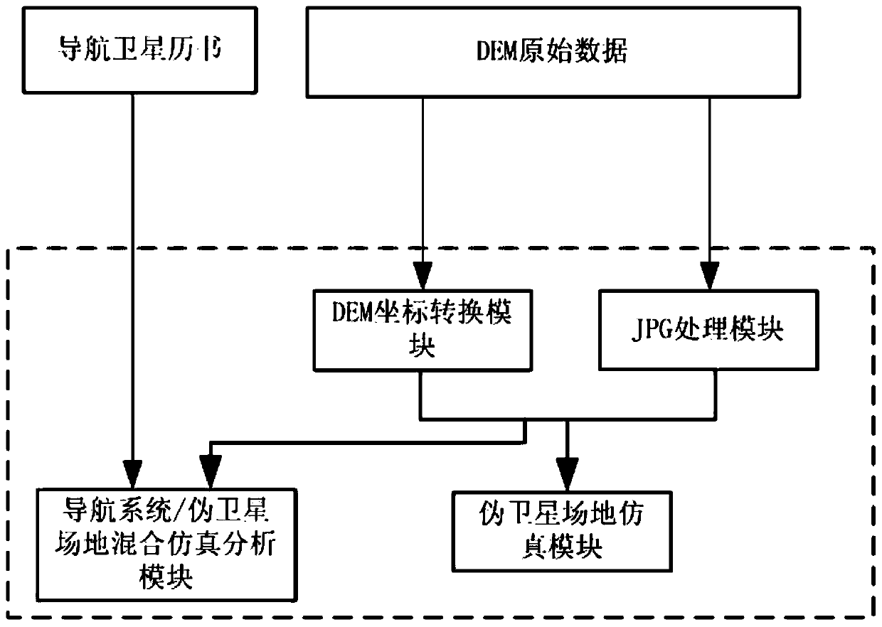
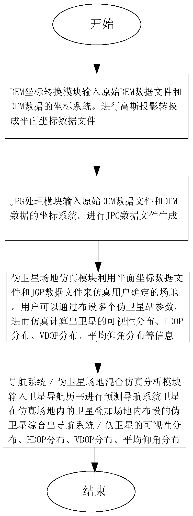
[0027] A pseudolite site simulation layout method based on DEM data processing, comprising the following steps:

[0028] (1) Input the original DEM data of the site and the coordinate information of the DEM data, and use the coordinate information of the DEM data to convert the original DEM data into plane coordinate data through Gaussian projection;

[0029] (2) Generate image data with elevation color according to the original DEM data and the coordinate information of the DEM data;

[0030] (3) Display the site image according to the image data, wait for the user to lay out pseudolites in the site image and configure the antenna parameters and transmit power of each pseudolite. The actual position coordinates of the satellites in the site; when deploying pseudolites, you can directly operate on the site image by clicking with the mouse, or yo...


PUM


Abstract

The invention discloses a pseudo-satellite site simulation layout method based on DEM data processing, and belongs to the technical field of pseudo-satellite navigation and positioning. The method comprises the following steps: converting original DEM data into plane coordinate data; generating image data with an elevation color; waiting for a user to arrange pseudo-satellites in the site image and configure antenna parameters and transmitting power of each pseudo-satellite, and calculating actual position coordinates of each pseudo-satellite in the site; visibility information, HDOP information, VDOP information and average elevation angle information of all points in the field are calculated through simulation and displayed in a field image in a visual mode. According to the method, theDEM data is calculated, all positions in a calculation area do not need to be searched blindly, only simulation information of DEM point locations needs to be calculated, the method has the advantagesof being small in calculation amount, high in precision and reliable in effect, and in addition, hybrid simulation of the navigation systems and the pseudo-satellites can be achieved by inputting satellite almanac information of the navigation systems.

Description

technical field [0001] The invention relates to the technical field of pseudolite navigation and positioning, in particular to a pseudolite site simulation layout method based on DEM data processing. Background technique [0002] At present, satellite navigation systems represented by Beidou and GPS are more and more widely used. However, in some cases, such as in urban "canyons" or valleys, positioning cannot be reliably determined due to too few satellites in view or poor geometry. Indoors, positioning using satellites is almost impossible because the satellite navigation signal is quite weak, or not received at all in some places. To solve these problems, arranging a certain number of pseudolites in appropriate positions is beneficial to form a geometric figure with sufficient strength, thereby improving the accuracy of the navigation and positioning solution to a great extent. [0003] In the prior art, pseudolite deployment is generally based on a location search meth...

Claims


Application Information

Patent Timeline
IPC IPC(8): G06T7/70G06T11/00G01S19/42
CPCG06T7/70G06T11/001G01S19/42Y02D30/70
Inventor 陈亮展昕孟海涛王迪张红敏赵胜
Owner NO 54 INST OF CHINA ELECTRONICS SCI & TECH GRP
Why Eureka
Try Eureka