Method and device for determining road elevation

A determination method and road technology, applied in the field of road elevation determination, can solve the problems of inability to use directly, high cost, and high acquisition cost, and achieve the effect of good three-dimensional effect, reduced acquisition cost, and strong real-time data.

Active Publication Date: 2020-08-07
ALIBABA GRP HLDG LTD
View PDF8 Cites 2 Cited by
  • Summary
  • Abstract
  • Description
  • Claims
  • Application Information

AI Technical Summary

Problems solved by technology

[0003] The inventor found that most of the current two-dimensional electronic maps are processed based on Global Positioning System (Global Positioning System, GPS) data, and the elevation data obtained only through GPS data has large errors and cannot be used directly
Although the map data collected by h

Method used


Image

  • Method and device for determining road elevation
  • Method and device for determining road elevation
  • Method and device for determining road elevation

Examples


Embodiment Construction

[0028] Exemplary embodiments of the present disclosure will be described in more detail below with reference to the accompanying drawings. Although exemplary embodiments of the present disclosure are shown in the drawings, it should be understood that the present disclosure may be embodied in various forms and should not be limited by the embodiments set forth herein. Rather, these embodiments are provided for more thorough understanding of the present disclosure and to fully convey the scope of the present disclosure to those skilled in the art.

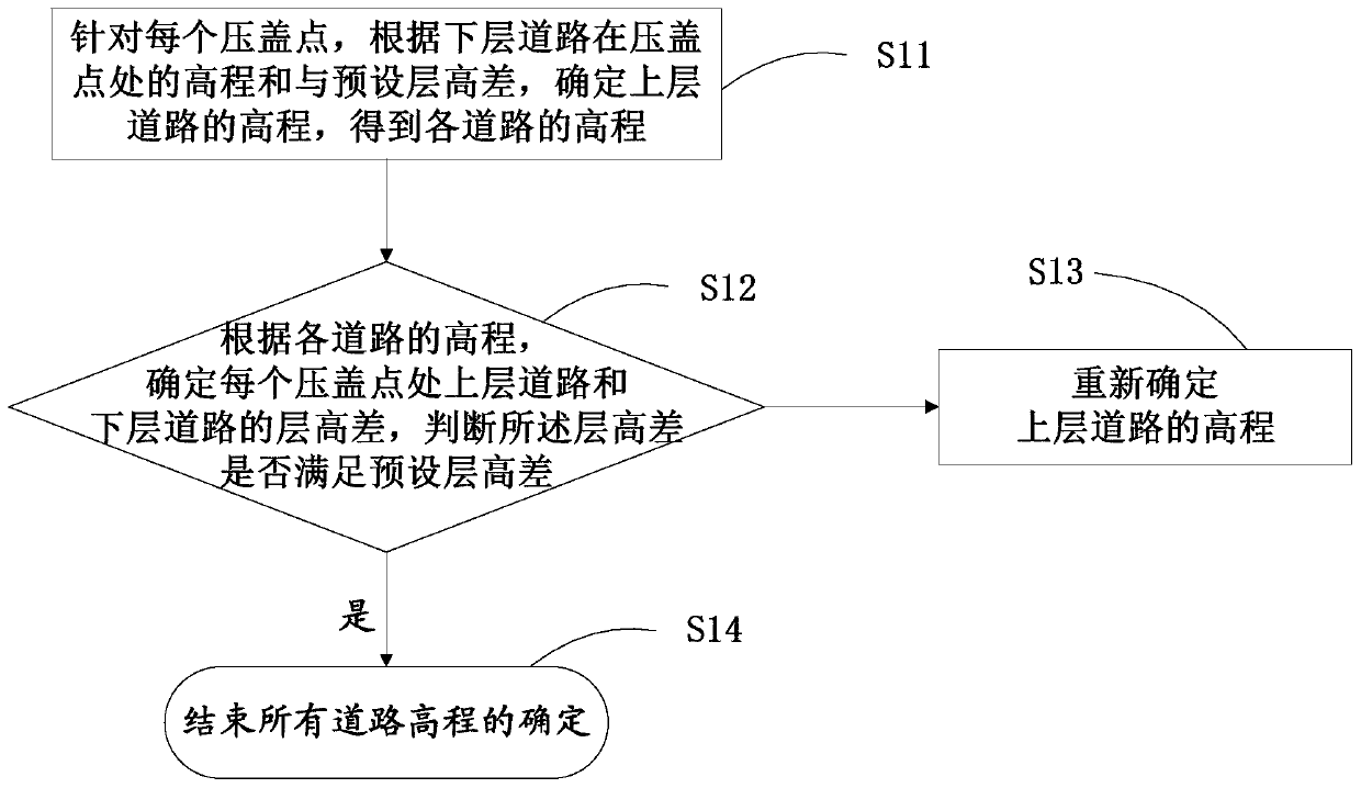
[0029] In order to solve the problems of high acquisition cost and slow update of 3D road network data in the prior art, or low reliability and poor simulation of 3D road network data elevation, the embodiment of the present invention provides a method for determining road elevation, which can reasonably Simulate the elevation of the road to realize the three-dimensional display of the road; at the same time, the cost of data acquis...


PUM


Abstract

The invention discloses a method and a device for determining road elevation. The method comprises the steps that for each gland point, the elevation of an upper-layer road is determined according tothe sum of the elevation of a lower-layer road at the gland point and the preset height difference, and the elevation of each road is obtained; wherein the cover pressing points are intersection points of the upper-layer road and the lower-layer road which have a cover pressing relationship on a two-dimensional plane; according to the elevation of each road, a judgment is made that the height difference between the upper-layer road and the lower-layer road at each gland point, and a judgment is made as to whether the height difference meets the preset height difference or not; if not, the elevation of the upper road is re-determined; wherein the height difference between the upper-layer road and the lower-layer road corresponding to all the re-determined gland points meets the preset height difference. The elevation of each road can be reasonably simulated, and three-dimensional display of each road is realized; meanwhile, the data acquisition cost is low, and the updating real-time performance is high.

Description

technical field [0001] The invention relates to the technical field of electronic maps, in particular to a method and device for determining road elevation. Background technique [0002] With the increasing development of urban traffic roads, more and more elevated roads are being built. Since two-dimensional electronic maps cannot directly display the spatial distribution and positional relationship of elevated roads, existing applications have more and more demands for three-dimensional maps. [0003] The inventors found that most of the current two-dimensional electronic maps are processed based on Global Positioning System (Global Positioning System, GPS) data, and the elevation data obtained only through GPS data has large errors and cannot be used directly. Although the map data collected by high-precision map collection vehicles has high precision and can meet the requirements of 3D maps, it cannot be collected on a large scale due to its high collection cost. [000...

Claims


Application Information

Patent Timeline
IPC IPC(8): E01C23/00G06F30/13
CPCE01C23/00
Inventor 万斌张悦
Owner ALIBABA GRP HLDG LTD
Why Eureka
Try Eureka