Shallow soil landslide early warning method based on digital topographic map and application

A technology of shallow soil quality and topographic maps, applied in the direction of alarms, complex mathematical operations, instruments, etc., can solve the problems of complex early warning work, poor applicability of disaster prevention, and many landslide factors, so as to improve the applicability of disaster prevention and the efficiency of early warning Effect

Active Publication Date: 2022-03-04
CHENGDU UNIVERSITY OF TECHNOLOGY +1
View PDF8 Cites 0 Cited by
  • Summary
  • Abstract
  • Description
  • Claims
  • Application Information

AI Technical Summary

Problems solved by technology

[0005] The multi-level comprehensive monitoring and early warning method for landslide disasters disclosed in this patent document requires a large amount of historical record monitoring data of landslides, and then calculates the critical threshold of landslide monitoring and early warning through landslide deformation an

Method used


Image

  • Shallow soil landslide early warning method based on digital topographic map and application
  • Shallow soil landslide early warning method based on digital topographic map and application
  • Shallow soil landslide early warning method based on digital topographic map and application

Examples


Embodiment 1

[0065] A method for early warning of shallow soil landslides based on digital topographic maps, comprising the following steps:

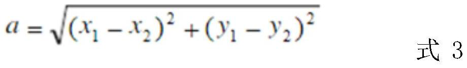
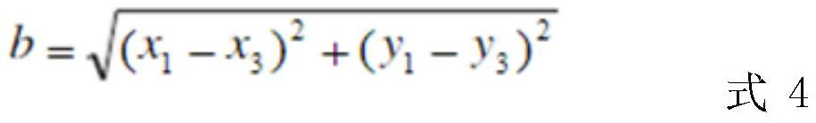
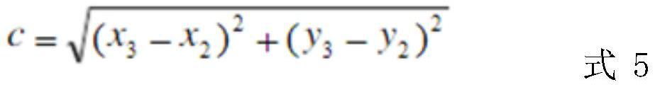
[0066] a. Through the terrain DEM data, according to the contour line of the topographic map, determine the slope with a depression in the cross section, and then determine the two sides of the landslide from the position of the straight section or the downward convex section on both sides, in the middle of the landslide body, Vertical to the bottom boundary, connect a straight line to the middle point convex upward along the contour line of the topographic map as the middle line;

[0067] b. From the bottom middle line to the top, determine the middle point on the middle line of each grid line, and the distance between the middle points is the DEM point distance;

[0068] c. Through the middle point, draw a line parallel to the bottom edge perpendicular to the middle line, intersect with the outer boundary of the landslide, the intersection point o...

Embodiment 2

[0094] A method for early warning of shallow soil landslides based on digital topographic maps, comprising the following steps:

[0095] a. Through the terrain DEM data, according to the contour line of the topographic map, determine the slope with a depression in the cross section, and then determine the two sides of the landslide from the position of the straight section or the downward convex section on both sides, in the middle of the landslide body, Vertical to the bottom boundary, connect a straight line to the middle point convex upward along the contour line of the topographic map as the middle line;

[0096] b. From the bottom middle line to the top, determine the middle point on the middle line of each grid line, and the distance between the middle points is the DEM point distance;

[0097] c. Through the middle point, draw a line parallel to the bottom edge perpendicular to the middle line, intersect with the outer boundary of the landslide, the intersection point o...

Embodiment 3

[0131] A method for early warning of shallow soil landslides based on digital topographic maps, comprising the following steps:

[0132] a. Through the terrain DEM data, according to the contour line of the topographic map, determine the slope with a depression in the cross section, and then determine the two sides of the landslide from the position of the straight section or the downward convex section on both sides, in the middle of the landslide body, Vertical to the bottom boundary, connect a straight line to the middle point convex upward along the contour line of the topographic map as the middle line;

[0133] b. From the bottom middle line to the top, determine the middle point on the middle line of each grid line, and the distance between the middle points is the DEM point distance;

[0134] c. Through the middle point, draw a line parallel to the bottom edge perpendicular to the middle line, intersect with the outer boundary of the landslide, the intersection point o...


PUM


Abstract

The invention discloses a shallow soil landslide early warning method based on a digital topographic map, which belongs to the field of landslide prevention and control engineering, and is characterized by comprising the following steps of: a, connecting a straight line with middle points protruding upwards along a contour line of the topographic map to serve as a middle line; b, determining an intermediate point; c, forming three point groups of plane curvature; d, taking the arithmetic mean value of the gradient as the gradient alpha of the landslide mass; e, according to a terrain DEM data distribution principle, assignments of all points in each grid are the same; f, taking an arithmetic mean value; g, calculating a topographic factor T of the potential landslide mass; h, calculating a rainfall factor R; i, calculating a shallow soil landslide early warning judgment value P; and j, performing early warning according to the shallow soil landslide early warning judgment value P. According to the method, the shallow soil landslide can be pre-warned without a large amount of historical observation data of the landslide, the dangerous landslide body is determined in advance, and the disaster prevention applicability and the pre-warning efficiency are greatly improved.

Description

technical field [0001] The invention relates to the technical field of landslide prevention engineering, in particular to an early warning method and application of a shallow soil landslide based on a digital topographic map. Background technique [0002] Shallow soil landslide is a natural phenomenon that occurs in mountainous areas. The occurrence of shallow soil landslides often needs to meet three conditions: one is the terrain conditions that are conducive to the occurrence of shallow soil landslides; the other is sufficient soil material sources, that is, loose covering soil layers; Soil. These conditions comprehensively affect and determine the stability of slope soil. Among them, the influencing factors of terrain conditions on shallow soil landslides include: the slope gradient of the potential landslide body, the depression of the cross-section of the landslide body, the topography of the gentle slope on the upper side of the landslide body, and the topography of...

Claims


Application Information

Patent Timeline
IPC IPC(8): G08B31/00G08B21/10G06F17/18
CPCG08B31/00G08B21/10G06F17/18G01V1/008
Inventor 李阳春余斌杨凌崴陈文鸿
Owner CHENGDU UNIVERSITY OF TECHNOLOGY
Why Eureka
Try Eureka