Technology for identifying and analyzing stratums in VR (Virtual Reality) geological environment

A technology of geological environment and analysis technology, applied in the field of stratum identification and analysis, can solve problems such as the difficulty of identifying extremely irregular bodies and the inability to directly integrate sample data, and achieve the effect of improving the ability to analyze geological bodies

Inactive Publication Date: 2010-12-08
CHINA UNIV OF MINING & TECH (BEIJING)
View PDF2 Cites 57 Cited by
  • Summary
  • Abstract
  • Description
  • Claims
  • Application Information

AI Technical Summary

Problems solved by technology

The disadvantage of the Noddy method is that it cannot directly fuse sample dat

Method used


Image

  • Technology for identifying and analyzing stratums in VR (Virtual Reality) geological environment
  • Technology for identifying and analyzing stratums in VR (Virtual Reality) geological environment
  • Technology for identifying and analyzing stratums in VR (Virtual Reality) geological environment

Examples


Embodiment 1

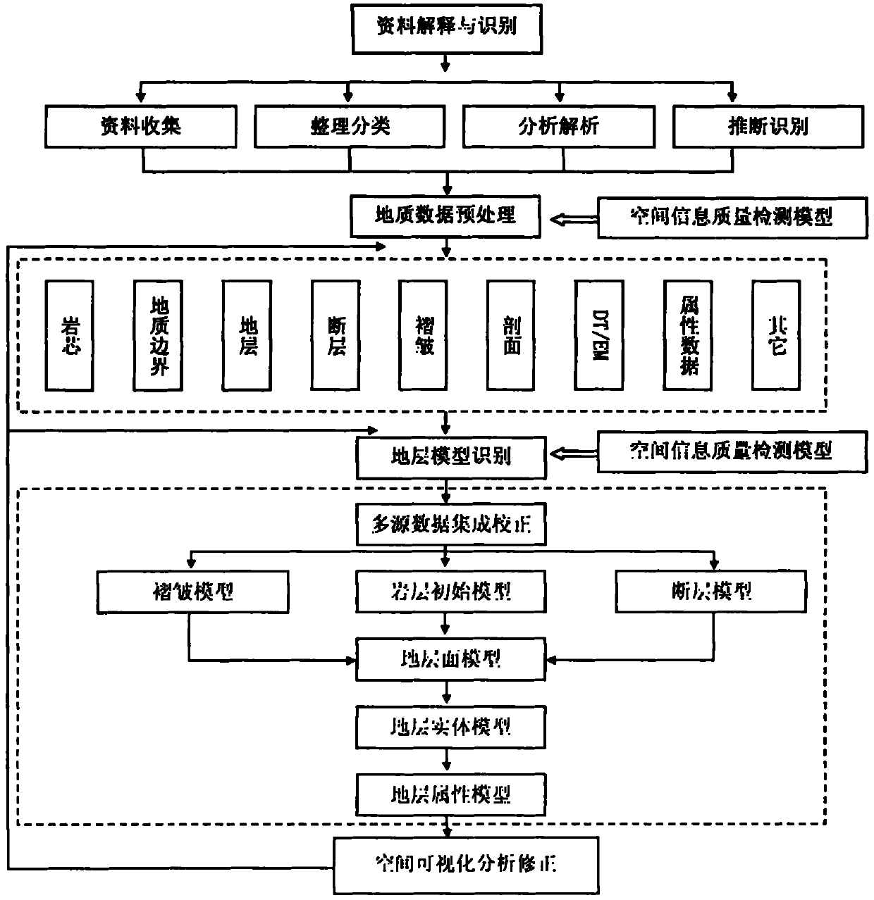
[0058] Taking a coal mine of Kailuan Group as an example, this paper introduces the stratum identification and analysis technology under the VR geological environment. The main steps and identification results are as follows:

[0059] 1. Using theoretical methods such as multi-source data integration and uncertainty analysis, the preprocessed multi-source data is integrated, coupled, and transformed. At the same time, data incompleteness, logical inconsistency, etc. Deterministic analysis, error detection and error analysis correction.

[0060] 2. Fault plane identification. According to the data collected in the study area, due to the limited data of boreholes and 2D profiles, almost all faults cannot control their spatial occurrence through the data from boreholes or 2D profiles. Based on the theoretical method of the fault mathematical model, on the basis of the deduction of the fault plane, combined with the effective breakpoint data, it can further interpolate and fit ea...


PUM


Abstract

The invention relates to a technology for identifying and analyzing stratums in VR (Virtual Reality) geological environment. On the basis of data explanation and identification, the technology comprises the following steps of: (1) pretreating geological data; (2) identifying and constructing three-dimensional stratum models; and (3) visually analyzing and correcting space. Each step needs to be correspondingly verified and detected according to a space information quality detecting model. The invention provides a brand-new high-technology measure for geologists, which realizes the form representation (space representation) of the geological data by adopting three-dimensional stratum geometrical identification and multi-dimensional attribute identification and combining with a static simulation visualization technology and realizes the dynamic representation (space-time representation) of geological models by adopting application models related to physical rules, an identification and analysis method and knowledge representation and combining a dynamic simulation visualization technology, thereby finally realizing the reality sense construction of VR geological realities, and in the other words, the technology is used for simulating realizable geological environment in practice or geological environment actually difficult to realize or geological environment which can not be realized fundamentally in a VR environment generated by a computer.

Description

technical field [0001] The invention relates to a stratum identification and analysis technology, in particular to a stratum identification and analysis technology under a VR geological environment using existing geological data. Background technique [0002] In order to describe and study the spatial distribution of strata in the study area, the distribution of lithology, the location of gold and mines, the calculation of exploration reserves, etc., and understand the geological characteristics, the existing geological data can be used for stratum identification and visual analysis and display. It can not only provide geologists with an intuitive way to observe and study the spatial distribution of geological units and their interrelationships, but also effectively preserve and manage a large number of existing geological data and materials in the study area. The survey work is inspected to provide a strong geological basis for subsequent survey design and construction oper...

Claims


Application Information

Patent Timeline
IPC IPC(8): E21B49/00
Inventor 武强徐华
Owner CHINA UNIV OF MINING & TECH (BEIJING)
Why Eureka
Try Eureka