Method to overcome space unorientation and delusions

A spatial orientation and obstacle technology, applied in the field of traffic safety, can solve the problems of inappropriate spatial positioning and lack of real-time spatial information.

Active Publication Date: 2015-06-17
FOURTH MILITARY MEDICAL UNIVERSITY
View PDF3 Cites 0 Cited by
  • Summary
  • Abstract
  • Description
  • Claims
  • Application Information

AI Technical Summary

Problems solved by technology

GPS maps can provide real-time plane traffic information, and have been widely used in vehicles such as cars, but lack real-time spatial information
In addition, GPS technology originated from the United States, so it is not suitable for the spatial positioning of various sports vehicles (such as aircraft) of our military

Method used


Image

  • Method to overcome space unorientation and delusions
  • Method to overcome space unorientation and delusions
  • Method to overcome space unorientation and delusions

Examples


Embodiment Construction

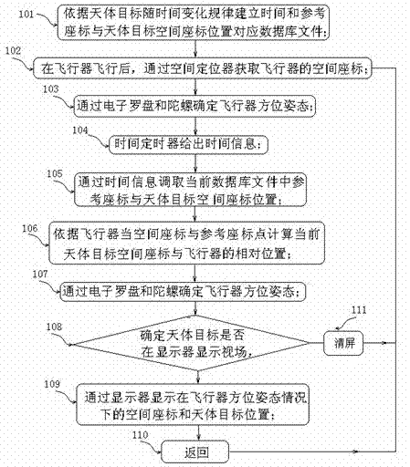
[0031] Such as figure 1 As shown, a method for overcoming spatial orientation barriers and illusions, the specific steps (taking an airplane as an example) are as follows:

[0032] Step 101, establishing a database file corresponding to the time and reference coordinates and the spatial coordinate position of the celestial object according to the change rule of the celestial object with time;

[0033] Step 102, after the aircraft flies, obtain the spatial coordinates of the aircraft through the space locator;

[0034] Step 103, determining the orientation and attitude of the aircraft through the electronic compass and gyroscope;

[0035] Step 104, the time timer provides time information;

[0036] Step 105, retrieve the reference coordinates and the spatial coordinate positions of the celestial object in the current database file through the time information;

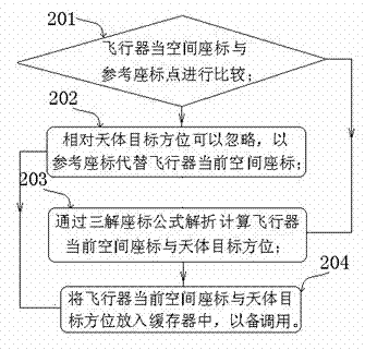
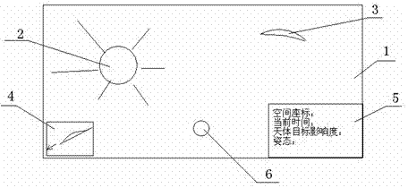
[0037] Step 106, calculating the relative position between the current space coordinates of the celestial object a...


PUM


Abstract

The invention relates to a method for a pilot to overcome space unorientation and delusions. The method comprises the steps as follows: 1) according to a law that a celestial body changes along with time, establishing a database file of time and reference coordinate, which are corresponding to a celestial body target space coordinate position; 2) after the takeoff of an aircraft, acquiring the space coordinate of the aircraft via a space locator; 3) determining the direction and the gesture of aircraft via an electric compass and a spinning top; 4) offering time information via a time controller; 5) transferring the reference coordinate and a celestial body object coordinate position in the current database file via the time information; 6) calculating the relative positions of the current celestial body object target space coordinate and the a reference coordinate point according to the direction and the gesture of the aircraft; 7) determining the direction and the gesture of the aircraft of the electronic compass and the spinning top; 8) determining whether the viewing field of the celestial body is displayed by a display or not according to the direction and the gesture of the aircraft; 9) displaying the space coordinate and the celestial body target position under the conditions of the direction and the gesture of the aircraft; and 10) returning to the Step 2). According to the invention, traffic accidents are avoided.

Description

technical field [0001] The invention relates to traffic safety, in particular to a method for drivers to overcome spatial orientation obstacles and illusions during driving. Background technique [0002] People's spatial position is judged by vision, vestibular sense, proprioception, etc., among which vision plays a decisive role. When a fast-moving mobile device, such as an airplane, high-speed train or automobile, lacks an external reference object or the reference object is unclear (cannot be positioned by vision), the driver may not be able to form a sense of the spatial position of himself (the mobile device). Correct judgment leads to spatial disorientation and illusions, such as various types of flying illusions. Spatial disorientation and the resulting illusion of flight are an important cause of flight accidents. During the delusions, once there is a clear visual cue, such as seeing the horizon line in flight, the illusion usually disappears immediately. Illu...

Claims


Application Information

Patent Timeline
Patent Type & Authority Patents(China)
IPC IPC(8): G01C21/00G01C21/20
Inventor 张作明张浩
Owner FOURTH MILITARY MEDICAL UNIVERSITY
Why Eureka
Try Eureka