Road feature extracting method based on fracture surface subdivision

A feature extraction and segmentation technology, applied in the re-radiation of electromagnetic waves, the use of re-radiation, measurement devices, etc., can solve the problems of safety hazards for driving and measurement personnel, unguaranteed position measurement accuracy, and high subjective arbitrariness of personnel. The effect of eliminating personal safety hazards, application value of major projects, and shortening the data acquisition cycle

Active Publication Date: 2014-02-26
中交城乡建设规划设计研究院有限公司
View PDF3 Cites 26 Cited by
  • Summary
  • Abstract
  • Description
  • Claims
  • Application Information

AI Technical Summary

Problems solved by technology

[0004] 1. The method of manual field measurement requires a large amount of human resources, which not only has high measurement cost, but also has low work efficiency and heavy workload;
[0005] 2. For highway reconstruction and expansion, the field measurement method requires a lot of manual on-road measurement, which will interfere with normal traffic on the road and cause serious safety hazards to both driving and surveying personnel;
[0006] 3. When manually picking up laser point cloud data to collect road features, the subjective randomness of personnel is large, and the position measurement accuracy cannot be guaranteed

Method used


Image

  • Road feature extracting method based on fracture surface subdivision
  • Road feature extracting method based on fracture surface subdivision
  • Road feature extracting method based on fracture surface subdivision

Examples


Embodiment 1

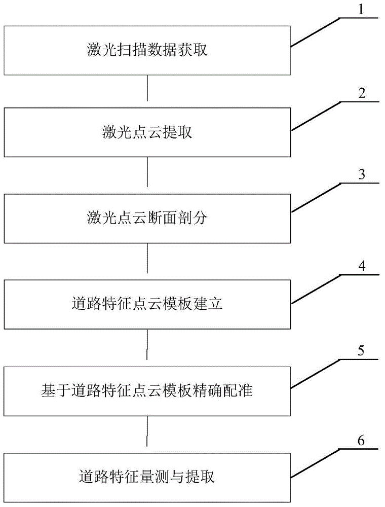
[0025] A road feature extraction method based on section division, such as figure 1 As shown, it is suitable for the extraction of features such as road surfaces and protective facilities. Each step is described in detail as follows:

[0026] The first step, the acquisition of laser scanning data

[0027] Using vehicle-mounted laser radar measurement equipment, the vehicle travels on the road at a speed of 40-60 km / h, and conducts high-density field scanning on both sides of the road to obtain field data; when calculating in the office, it is observed synchronously Based on the GPS reference station data, the observation data obtained by the vehicle GPS and the IMU data are used for comprehensive processing, and the vehicle trajectory is obtained through calculation, and then the accurate original laser scanning point cloud data is obtained. The average point spacing of the laser point cloud is less than 5cm , and finally complete the data collection in the field and the pre...


PUM


Abstract

The invention belongs to the field of laser radar measuring, and particularly discloses a road feature extracting method based on fracture surface subdivision. The method comprises the step of obtaining laser scanning point cloud data through a laser radar measuring device, the step of determining a road feature guide line and extracting road feature nearby point cloud data, the step of generating subdivision sections according to the road feature guide line and a certain step length and calculating the coordinates of proximal point clouds in a subdivision section coordinate system to finish fracture surface subdivision of laser point clouds, the step of selecting one subdivision section with integrated feature information and generating a road feature point cloud template in which a user is interest, the step of determining final conversion model parameters of the road feature point cloud template and the subdivision section point clouds, and the step of calculating the space coordinates of road features, extracting needed features according to the characters of the road features and finally finishing measuring and extracting of the road features. The idea of the fracture surface subdivision is introduced, the complex road features are automatically measured and extracted, the working efficiency is remarkably improved on the premise of guaranteeing measuring precision, and the method has remarkable economic and social benefits.

Description

technical field [0001] The invention relates to the technical field of laser radar measurement, in particular to a road feature extraction method based on section division, which can quickly and accurately acquire the spatial geometric position of road features along the line. Background technique [0002] With the rapid development of my country's economy and society, the service level of many early-built highways has declined, unable to meet the growing needs of economic and social development, and are facing reconstruction or expansion. my country's road construction has gradually formed a situation of "equal emphasis on new road construction and reconstruction and expansion", and road reconstruction and expansion will become the focus of my country's road construction in the future. [0003] For highway reconstruction and expansion survey and design projects, fast and accurate acquisition of spatial information of existing roads is a key prerequisite. At present, the me...

Claims


Application Information

Patent Timeline
Patent Type & Authority Applications(China)
IPC IPC(8): G01S17/88
CPCG01S7/4802G01S17/88
Inventor 陈楚江明洋余绍淮王丽园张霄余飞
Owner 中交城乡建设规划设计研究院有限公司
Why Eureka
Try Eureka