Seed maize field identification method and system based on multi-source and multi-temporal high resolution remote sensing data

A technology for seed production of corn and remote sensing images, which is applied in character and pattern recognition, instruments, computer parts, etc., can solve the problems of inaccurate distinction between corn fields and field corn fields, and inaccurate seed production of corn fields, etc.

Inactive Publication Date: 2017-01-25
CHINA AGRI UNIV
View PDF3 Cites 44 Cited by
  • Summary
  • Abstract
  • Description
  • Claims
  • Application Information

AI Technical Summary

Problems solved by technology

[0007] Embodiments of the present invention provide a multi-source, multi-temporal, high-resolution remote sensing image identification method and system for seed production cornfields, which are used to solve the pro

Method used


Image

  • Seed maize field identification method and system based on multi-source and multi-temporal high resolution remote sensing data
  • Seed maize field identification method and system based on multi-source and multi-temporal high resolution remote sensing data
  • Seed maize field identification method and system based on multi-source and multi-temporal high resolution remote sensing data

Examples


Embodiment Construction

[0048] In order to make the purpose, technical solutions and advantages of the embodiments of the present invention clearer, the technical solutions in the embodiments of the present invention will be clearly and completely described below in conjunction with the drawings in the embodiments of the present invention. Obviously, the described embodiments It is a part of embodiments of the present invention, but not all embodiments. Based on the embodiments of the present invention, all other embodiments obtained by persons of ordinary skill in the art without creative efforts fall within the protection scope of the present invention.

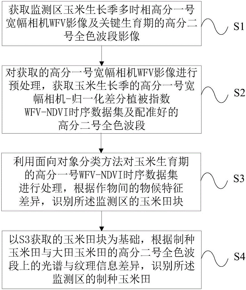
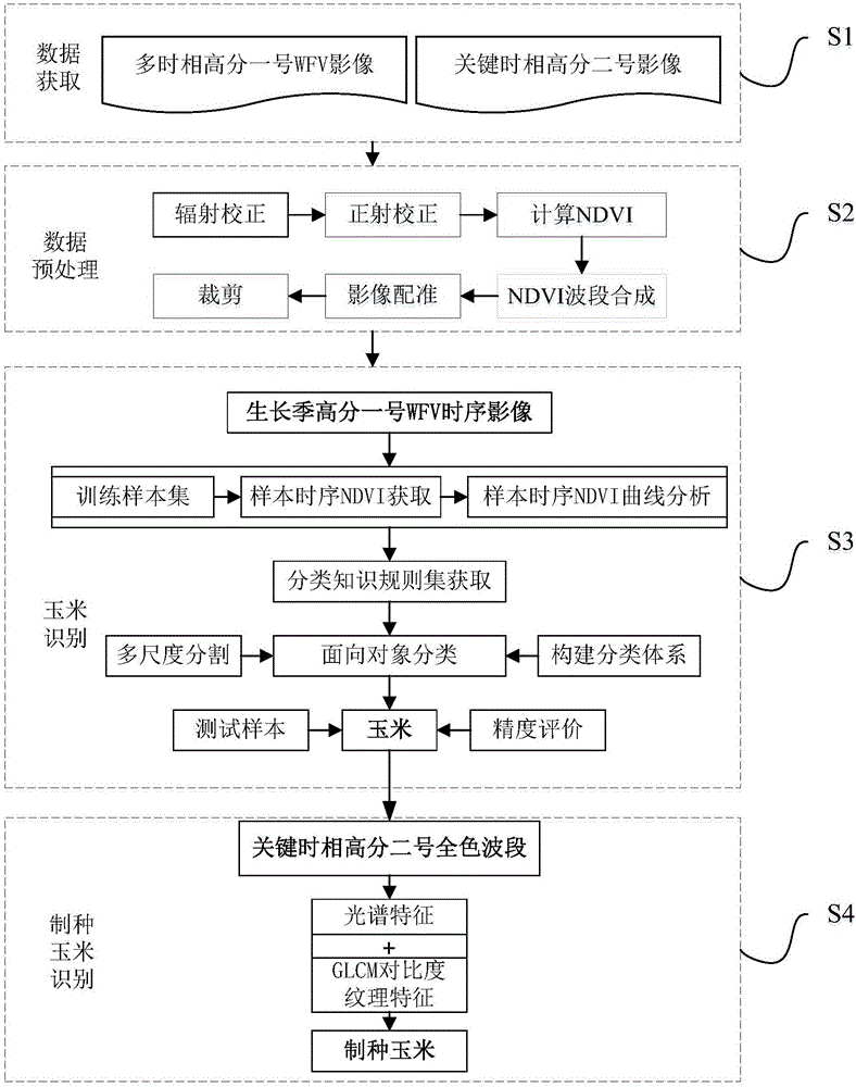
[0049] figure 1 It is a schematic flow chart of a multi-source multi-temporal high-resolution remote sensing image recognition method for seed production cornfields according to an embodiment of the present invention. Such as figure 1 Shown, the method of this embodiment comprises:

[0050] S1: Obtain WFV images of the multi-temporal Gaofen-1 w...


PUM


Abstract

The invention provides a seed maize field identification method and system based on multi-source and multi-temporal high resolution remote sensing data. The method comprises the steps of 1) getting the image of No. 1 multi-temporal high resolution Wild Field View (WFV) for the monitored maize field in maize growth season and the No. 2 high resolution panchromatic band image for key growth period; pre-processing the image of No. 1 multi-temporal high resolution Wild Field View (WFV) and getting xxx of No. 1 multi-temporal high resolution Wild Field View normalized difference vegetation index WFV NDVI Time Series Dataset and well-aligned High-Score 2# Panchromatic Band; S3: Application of Object-oriented Classification Method for Processing of WFV NDVI timing dataset of High-Score 1# in Maize Growing Season, to identify the cornfield block in the said monitoring area according to the phenological differences between crops; S4: to identify the seed maize field in the monitoring area based on the block acquired by S3 and according to the difference in spectrum and texture information between the seed maize field and the growing maize field on High-Score 2 panchromatic wave band. The present invention provides an accurate, economic and objective method for remote sensing and monitoring of seed maize breeding.

Description

technical field [0001] The invention relates to the technical field of remote sensing image processing, in particular to a method and system for identifying seed production cornfields of multi-source, multi-temporal high-resolution remote sensing images. Background technique [0002] This section introduces readers to background technologies that may be related to various aspects of the present invention, and it is believed that useful background information can be provided to readers, thereby helping readers to better understand various aspects of the present invention. Accordingly, it is to be understood that the descriptions in this section are for the purposes stated above and do not constitute admissions of prior art. [0003] Hybrid seed production is an important link in the production of major crops such as corn and rice. Mastering the seed production area and yield of major crop seeds is the basis for balancing the seed supply and demand market. At present, the phe...

Claims


Application Information

Patent Timeline
IPC IPC(8): G06K9/00G06K9/62G06K9/34G06K9/46
CPCG06V20/188G06V10/267G06V10/40G06F18/24
Inventor 刘哲孙海艳金虹杉李智晓张超宁明宇陈英义
Owner CHINA AGRI UNIV
Why Eureka
Try Eureka