Method for crop mapping by using Gaofen-2 and Gaofen-3 based on field combination

A crop, high-scoring technology, applied in educational tools, character and pattern recognition, maps/plans/charts, etc., can solve the problems of inaccurate plot space, inaccurate crop mapping, etc., achieving less manual intervention and scalable algorithms Effect

Inactive Publication Date: 2019-08-30
INST OF REMOTE SENSING & DIGITAL EARTH CHINESE ACADEMY OF SCI
View PDF0 Cites 2 Cited by
  • Summary
  • Abstract
  • Description
  • Claims
  • Application Information

AI Technical Summary

Problems solved by technology

[0004] The present invention provides a new method for extracting crop planting structures using optical remote sensing data and polarization synthetic aperture radar ( figure 1

Method used


Image

  • Method for crop mapping by using Gaofen-2 and Gaofen-3 based on field combination
  • Method for crop mapping by using Gaofen-2 and Gaofen-3 based on field combination
  • Method for crop mapping by using Gaofen-2 and Gaofen-3 based on field combination

Examples


Embodiment Construction

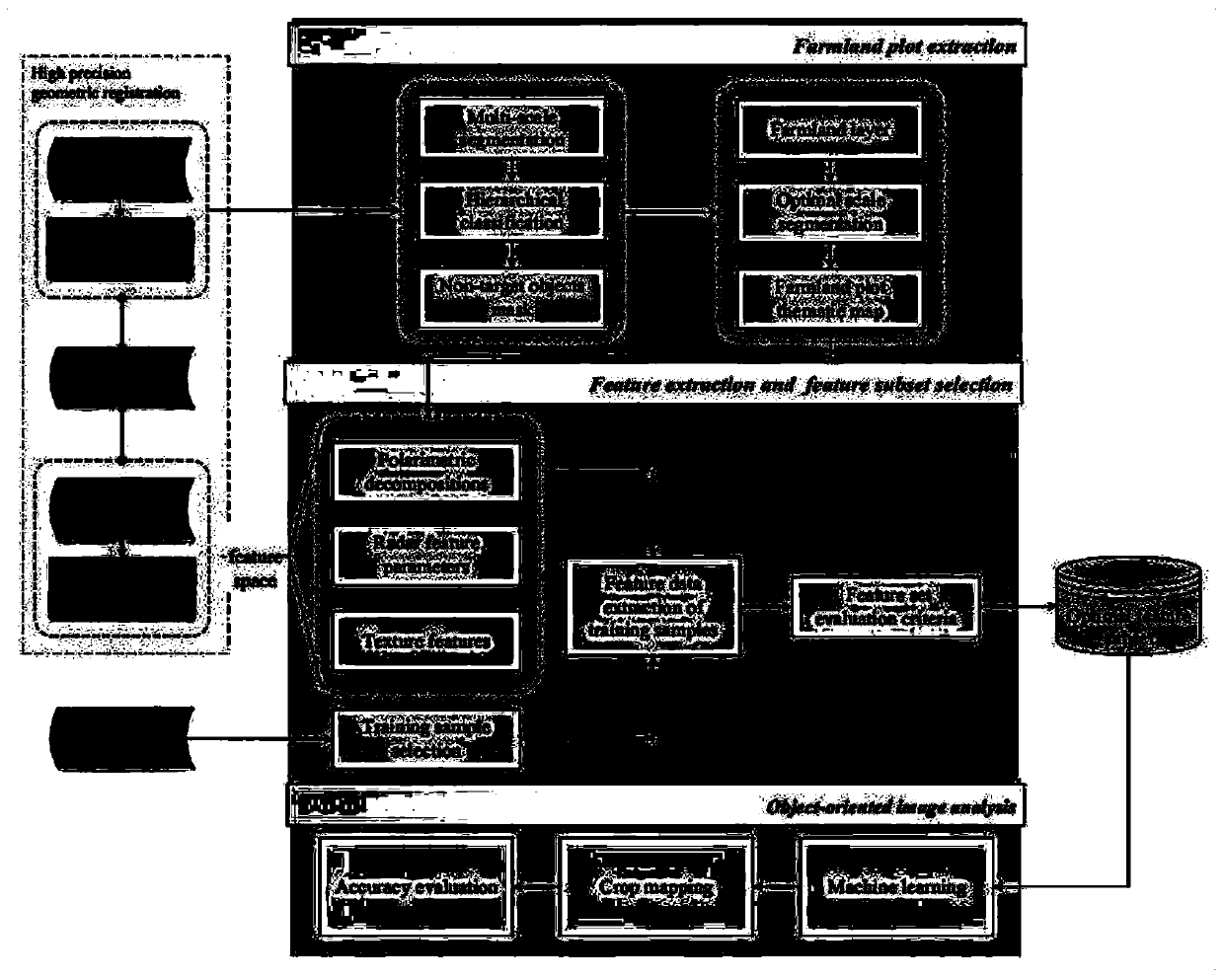
[0009] 1 Farmland small area extraction

[0010] Different types of ground features require appropriate distances and scales to be effectively and completely presented, so multi-scale segmentation is used to extract plot vectors. The present invention first uses object-oriented technology to perform multi-scale segmentation of GF-2 data in the research area, obtains the distribution range of each block type through the supervised classification of support vector machines, and masks the extracted non-agricultural land blocks to obtain agricultural range. Secondly, within the range of agricultural land, the optimal segmentation scale of the range of cultivated land is obtained based on the local variance method, and the information of farmland plots is accurately extracted to realize the extraction of crop planting structure supported by plot primitives.

[0011] 2 feature extraction

[0012] The present invention adopts multiple polarization decomposition methods to conduct p...


PUM


Abstract

The invention discloses a method for crop mapping, and particularly relates to a method for crop mapping by using GaoFen-2 optical imaging and GaoFen-3 polarized synthetic aperture radar (POLSAR) databased on field combination. The advantages of multi-source remote sensing data are exploited fully, the problems of imprecise plot space and inaccurate crop mapping of remote sensing in crop mappingare solved, according to the study, a set of ''SAR-optics'' data collaborative crop planting structure remote sensing extraction models is developed by taking the space and time collaboration of SAR and optical remote sensing data as the point of penetration, multi-level collaboration is carried out on spatial information of optical images and characteristic information of SAR data to explore an automatic identification method of crop planting structure information based on multi-source remote sensing data supported by plot elements. The method mainly includes four steps of multi-scale segmentation of high spatial resolution images, SAR image characteristic extraction, optimal classification subset acquisition and object-oriented classification using SVM. According to the method, multi-temporal SAR (GaoFen-3) and optical imaging (GaoFen-2) are used as data sources, and collaboration processing is carried out by using "map" information of a cropland plot structure provided by GaoFen-2 images and polarization scattering, texture and other information of ground object characteristics provided by GaoFen-3 images so as to realize accurate identification of crop types and extraction of planting areas.

Description

technical field [0001] The invention relates to a method for crop mapping, in particular to a method for crop mapping based on field-based combined use of Gaofen-2 optical imaging and Gaofen-3 polarization synthetic aperture radar (PolSAR) data. Background technique [0002] As global climate change, energy demand, and population growth put increasing pressure on agricultural production, the risk of global or regional food supply shortages is also increasing. It is necessary to grasp the regional or global food production situation in real time to provide a basis for the formulation of regional and global food security and related policies. Crop planting structure is one of the components of the spatial pattern of crops, which describes the composition and layout of crops in a region or production unit, that is, the main types of crops and their spatial distribution. Satellite remote sensing technology can observe the earth at different times with different scales, differen...

Claims


Application Information

Patent Timeline
IPC IPC(8): G09B29/00G06K9/46G06K9/62
CPCG09B29/006G06V10/462G06F18/2411
Inventor 张新崔锦甜邓晚倩
Owner INST OF REMOTE SENSING & DIGITAL EARTH CHINESE ACADEMY OF SCI
Why Eureka
Try Eureka