Measurement method of subgrade earthwork filling and excavation balance based on tilt photography and BIM

A technology of oblique photography and measurement method, which is applied in the field of foundation soil survey, foundation structure engineering, construction, etc. It can solve the problems of inaccurate results, low efficiency, inaccurate balance cost and accounting of earthwork, fill and excavation, and reduce calculation Intensity, reducing labor intensity, and avoiding the effect of repeated handling work

Inactive Publication Date: 2019-11-22
中山云鹏航测信息科技有限公司
View PDF6 Cites 8 Cited by
  • Summary
  • Abstract
  • Description
  • Claims
  • Application Information

AI Technical Summary

Problems solved by technology

At present, the engineering quantity of subgrade filling and excavation is basically measured by manual calculation, which is inefficient and the results are not accurate.
[0005] At present, there is no solution to measure the actual earthwork balance of filling and excavation more accurately, resulting in inaccurate cost and calculation of earthwork balance of filling and excavation

Method used


Image

  • Measurement method of subgrade earthwork filling and excavation balance based on tilt photography and BIM

Examples


Embodiment 1

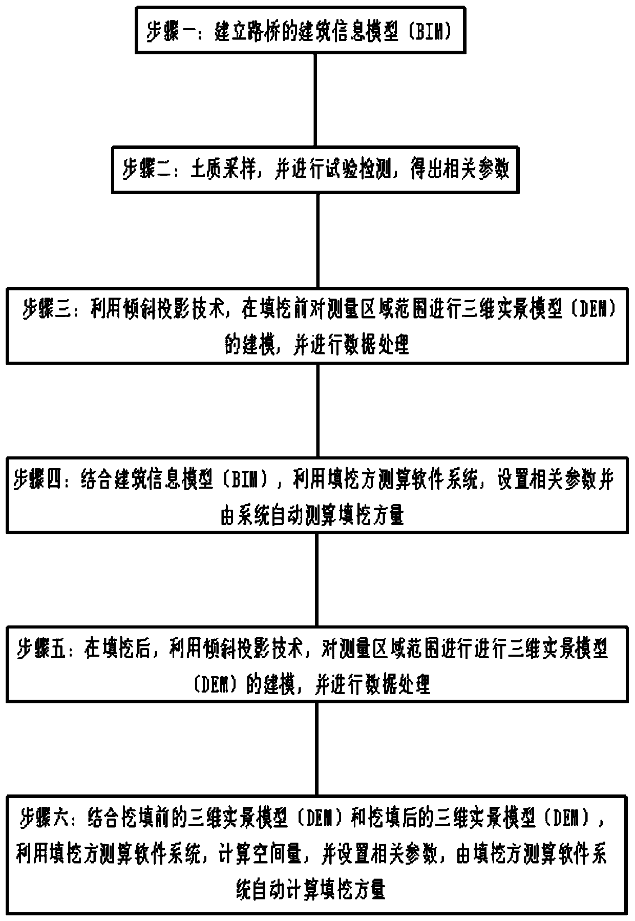
[0028] see figure 1 , a method for measuring the balance of subgrade earthwork filling and excavation based on oblique photography and BIM, the method includes the following steps:

[0029] Step 1: Establish the building information model (BIM) of the road and bridge. The building information model (BIM) is a parametric modeling. Various real attributes of the building artifacts can be simulated in the form of parameters, and relevant data statistics and calculations can be performed ; After the building information model (BIM) of the road and bridge is established and confirmed, the various real attributes and parameters of its constituent components have also been fixed (but it can still be adjusted according to the actual situation, such as the inspection found that the established BIM of the road and bridge has errors, etc. , and the adjustment is very convenient), you can get the design elevation, natural elevation and other parameters of the road and bridge BIM, input th...

Embodiment 2

[0038] see figure 1 , a method for measuring the balance of subgrade earthwork filling and excavation based on oblique photography and BIM, the method includes the following steps:

[0039] Step 1: Establish the building information model (BIM) of the road and bridge. The building information model (BIM) is a parametric modeling. Various real attributes of the building artifacts can be simulated in the form of parameters, and relevant data statistics and calculations can be performed ; After the building information model (BIM) of the road and bridge is established and confirmed, the various real attributes and parameters of its constituent components have also been fixed (but it can still be adjusted according to the actual situation, such as the inspection found that the established BIM of the road and bridge has errors, etc. , and the adjustment is very convenient), you can get the design elevation, natural elevation and other parameters of the road and bridge BIM, input th...

Embodiment 3

[0046] see figure 1 , a method for measuring the balance of subgrade earthwork filling and excavation based on oblique photography and BIM, the method includes the following steps:

[0047] Step 1: Establish the building information model (BIM) of the road and bridge. The building information model (BIM) is a parametric modeling. Various real attributes of the building artifacts can be simulated in the form of parameters, and relevant data statistics and calculations can be performed ; After the building information model (BIM) of the road and bridge is established and confirmed, the various real attributes and parameters of its constituent components have also been fixed (but it can still be adjusted according to the actual situation, such as the inspection found that the established BIM of the road and bridge has errors, etc. , and the adjustment is very convenient), you can get the design elevation, natural elevation and other parameters of the road and bridge BIM, input th...


PUM


Abstract

The invention discloses a measurement method of subgrade earthwork filling and excavation balance based on tilt photography and BIM. The measurement method comprises the following steps of building abuilding information modeling (BIM) of a road and a bridge; sampling, testing and detecting soil, and obtaining relevant parameters; carrying out the modeling of a three-dimensional real scene model (DEM) in the range of a measurement area before filling and excavation, and processing data; combined with the BIM, using a filling and excavation calculation software system to set relevant parametersand automatically calculating the volume of filling and excavation by the system; after filling and excavation, carrying out the modeling of the DEM and data processing in the range of the measurement area; and combined with the DEM before excavation and filling and the DEM after excavation and filling, using the excavation and filling calculation software system to automatically calculate the volume of excavation and filling. According to the measurement method, actual earthwork filling and excavation balance can be measured more accurate, and thus the cost and accounting of the earthwork filling and excavation balance are more accurate.

Description

technical field [0001] The invention relates to the technical field of road and bridge construction engineering measurement, in particular to a measurement method for subgrade earthwork filling and digging balance based on oblique photography and BIM. Background technique [0002] In the field of road and bridge construction engineering, there are a large number of earthwork filling and excavation work in the construction of roadbeds, including filling roadbeds, excavated roadbeds and half-filled and half-dug roadbeds. Filled subgrade refers to the subgrade that needs to be filled with soil (or stone) when the design elevation of the subgrade is higher than that of the natural ground; excavation subgrade means that when the design elevation of the subgrade is lower than the natural ground elevation, the natural ground needs to be excavated. A roadbed formed by digging; if one side of the roadbed is excavated and the other side is filled, it is called a half-filled and half-d...

Claims


Application Information

Patent Timeline
Patent Type & Authority Applications(China)
IPC IPC(8): E02D1/00
CPCE02D1/00
Inventor 李莲莲张立伟鲁承钢李克丁
Owner 中山云鹏航测信息科技有限公司
Why Eureka
Try Eureka