Astronomical positioning and photometry of space debris based on automatic determination of pointing error

A space debris and astronomical positioning technology, which is applied in astronomical navigation, surveying devices, surveying and navigation, etc., can solve the problems of correction accuracy influence, telescope pointing error correction accuracy, etc.

Active Publication Date: 2021-03-16
ZIJINSHAN ASTRONOMICAL OBSERVATORY CHINESE ACAD OF SCI
View PDF6 Cites 0 Cited by
  • Summary
  • Abstract
  • Description
  • Claims
  • Application Information

AI Technical Summary

Problems solved by technology

Even so, in the sky area with a low elevation angle, the correction accuracy of the telescope pointing error is low due to the influence of the correction accuracy of atmospheric refraction

Method used


Image

  • Astronomical positioning and photometry of space debris based on automatic determination of pointing error
  • Astronomical positioning and photometry of space debris based on automatic determination of pointing error
  • Astronomical positioning and photometry of space debris based on automatic determination of pointing error

Examples


Embodiment Construction

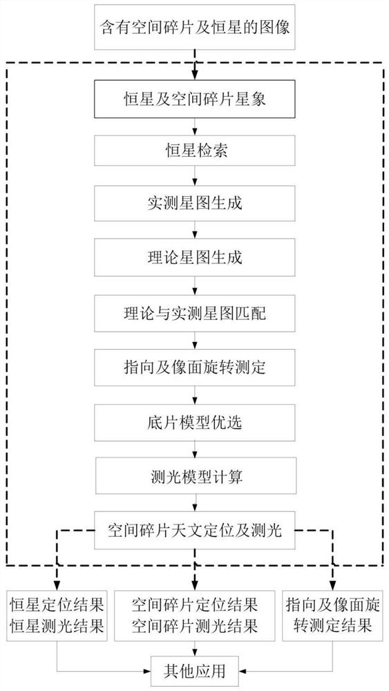
[0077] In order to better understand the technical content of the present invention, specific embodiments are given together with the attached drawings for description as follows.

[0078] to combine figure 1 , the present invention refers to a real-time astronomical positioning and photometry method for space debris based on automatic determination of pointing errors, said real-time astronomical positioning and photometry method comprising the following steps:

[0079] S1: Receive at least one frame of images including space debris and background stars, and obtain star image information of stars and space debris within the preset detection threshold on the image;

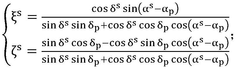
[0080] S2: Combined with the astronomical positioning star library, according to the shooting information corresponding to the image and the pointing information containing the pointing error in the center of the image (α p ,δ p ), retrieve the relevant information of all the stars satisfying the given magnitude ...


PUM


Abstract

The invention discloses a space debris real-time astronomical positioning and photometry method based on pointing error automatic measurement. The method comprises the following steps: obtaining a fixed star and a space debris star image; performing fixed star retrieval; generating a theoretical star map; generating an actually measured star map; matching the theoretical star map with the actuallymeasured star map; pointing and image plane rotation measurement; optimizing a negative film model; calculating a photometric model; and performing space debris astronomical positioning and photometry. According to the invention, the negative film model can be automatically optimized according to the observation view field; according to the given time and the image center pointing on the image, the image center pointing and the image plane rotation angle are automatically measured, automatic matching of fixed star theoretical coordinates and actually measured coordinates is achieved, automatic matching of gray level of the fixed star on the image and theoretical star magnitude of the fixed star is achieved, and therefore real-time astronomical positioning and photometry of space debris are achieved.

Description

technical field [0001] The invention relates to the technical field of space debris positioning, in particular to a method for real-time astronomical positioning and photometry of space debris based on automatic measurement of pointing errors. Background technique [0002] In many fields such as scientific research and military affairs, it is necessary to monitor space debris. On the one hand, it measures the position and changes of space debris in the sky at each observation moment, and determines the orbit of space debris, so as to obtain accurate information about space debris. Based on this requirement, accurate measurement of space debris is a very important basic link. Without accurate measurement of space debris, space debris orbit identification, cataloging orbit determination, and precise orbit determination cannot be realized. [0003] There are two methods to accurately measure the position of space debris: absolute positioning and relative positioning. Among the...

Claims


Application Information

Patent Timeline
Patent Type & Authority Patents(China)
IPC IPC(8): G01C21/02
CPCG01C21/025
Inventor 张晓祥高昕李希宇
Owner ZIJINSHAN ASTRONOMICAL OBSERVATORY CHINESE ACAD OF SCI
Why Eureka
Try Eureka