Geospatial information system suitable for police affair management

A geospatial information and policing technology, applied in the field of management information systems, can solve problems such as being unsuitable for mobile terminals, and achieve the effects of convenient and fast data sharing and safe and reliable data exchange.

Pending Publication Date: 2020-09-08
孟黎明
View PDF0 Cites 0 Cited by
  • Summary
  • Abstract
  • Description
  • Claims
  • Application Information

AI Technical Summary

Problems solved by technology

However, due to the large amount of basic data, most of the existing digital city management platforms are large systems, which are not suitable for use on mobile terminals. Therefore, it is necessary to invent a system that is easy to exchange data, is safe and reliable, and is convenient for mobile use and interaction. Geospatial Information System for Police Management

Method used


Image

  • Geospatial information system suitable for police affair management

Examples


Embodiment Construction

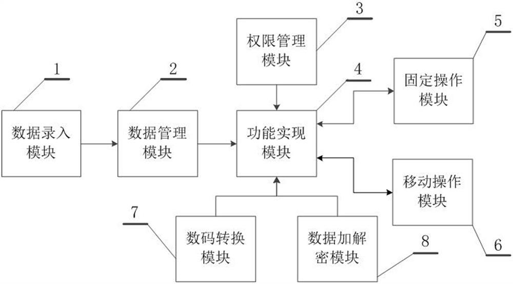
[0012] The present invention will be further described below in conjunction with the accompanying drawings, but the present invention is not limited in any way. Any transformation or replacement based on the teaching of the present invention belongs to the protection scope of the present invention.

[0013] as attached figure 1 As shown, the geospatial information system suitable for police management in the present invention includes a data entry module 1, a data management module 2, an authority management module 3, a function realization module 4, a fixed operation module 5 and a mobile operation module 6, the described The data entry module 1 is used to acquire the basic data of the system, the data management module 2 includes a database and a database operation interface, and is used for adding, deleting, checking and modifying the basic data, and the described authority management module 3 is used for different The login user assigns and manages the preset operating aut...


PUM


Abstract

The invention discloses a geospatial information system suitable for police affair management. The system comprises a data entry module, a data management module, an authority management module, a digital conversion module, a function implementation module, a data encryption and decryption module, a fixed operation module and a mobile operation module, the data entry module is used for acquiring basic data of the system; the data management module comprises a database and a database operation interface; the data processing module is used for adding, deleting, checking and modifying the basic data; the authority management module is used for distributing and managing preset operation authorities of the system for different login users of the system; wherein the digital conversion module isused for mutual conversion between specific data and a specific two-dimensional code, the function realization module provides a police affair management function interface, and the data encryption and decryption module is used for encrypting or decrypting data between login users during data exchange. Data storage is safe and controllable, data exchange is convenient and fast, and the system is suitable for police affair management scenes.

Description

technical field [0001] The invention belongs to the field of management information systems, and in particular relates to a geographic space information system suitable for police management. Background technique [0002] The research and construction of digital cities are rising all over the world, and cities have started digital city construction projects one after another. Digital city construction is the main component of national informatization, the core of regional informatization, and the only way to modernization. The construction and management of "digital city" is to use digital means to uniformly deal with various issues such as urban information and management, and to maximize the use of urban geographical resources, ecological environment, population, economic, social and other information resources to regulate and predict cities. To provide advanced technical means to supervise cities and realize multi-faceted city management business. However, due to the la...

Claims


Application Information

Patent Timeline
IPC IPC(8): G06F16/29G06Q10/10G06Q50/26
CPCG06F16/29G06Q10/103G06Q50/26
Inventor 孟黎明
Owner 孟黎明
Why Eureka
Try Eureka