Dynamic description method for high-water-consumption strip of water-drive reservoir

A water-flooding and water-consuming technology, which is used in earth-moving drilling, fluid production, measurement, etc., can solve the problem of inability to fully consider the particularity of high-water-consuming strips, the lack of effective description methods for high-water-consuming strips, and the difficulty of interpretation. and other problems to achieve the effect of improving the development effect

CN111911135AActive Publication Date: 2020-11-10CHINA UNIV OF PETROLEUM (EAST CHINA)
7 Cites 1 Cited by

Patent Information

Authority / Receiving Office
CN · China
Patent Type
Applications(China)
Current Assignee / Owner
Publication Date
2020-11-10

Smart Images

  • Figure 1
    Figure 1
  • Figure 2
    Figure 2
  • Figure 3
    Figure 3
Patent Text Reader

Abstract

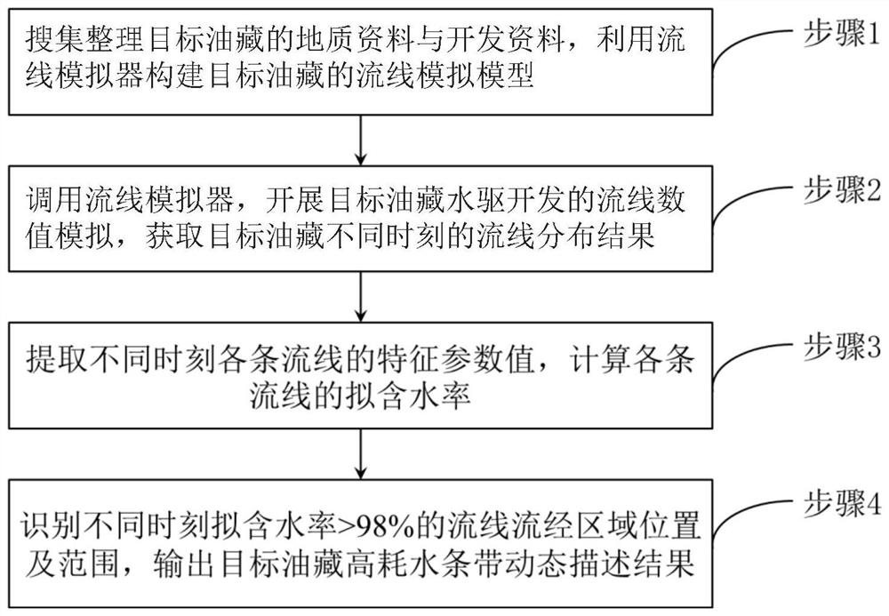
The invention relates to the technical field of oil and gas field development, and particularly discloses a dynamic description method for a high-water-consumption strip of a water-drive oil reservoir. The method comprises the following steps of 1, collecting and arranging geological data and development data of a target oil reservoir, and constructing a streamline simulation model of the target oil reservoir by utilizing a streamline simulator; 2, calling the streamline simulator, carrying out streamline numerical simulation of target oil reservoir water-drive development, and obtaining streamline distribution results of the target oil reservoir at different moments; 3, extracting characteristic parameter values of each streamline at different moments, and calculating the pseudo-water content of each streamline; and 4, identifying positions and ranges of streamline flowing regions with the quasi-water content being more than 98% at different moments, and outputting a dynamic description result of the high-water-consumption strip of the target oil reservoir. According to the method, the positions and ranges of the streamline flowing regions with the quasi-water content being more than 98% at different moments are rapidly recognized, dynamic description of the development positions, shapes and ranges of all high-water-consumption strips of the water-drive oil reservoir is achieved more accurately, and guidance is provided for improving the development effect of the water-drive oil reservoir.
Need to check novelty before this filing date? Find Prior Art

Description

technical field

[0001] The invention relates to the technical field of oil and gas field development, in particular to the technical field of high water consumption strips in water drive reservoirs. Background technique

[0002] The high water consumption strip refers to the connected area formed during the long-term water flooding process with low oil saturation, the displacement factor is much larger than other areas, and does not have the potential for continuous water flooding. Oilfield development enters the late stage of ultra-high water cut. Affected by reservoir heterogeneity, high water consumption bands generally develop, resulting in inefficient and ineffective circulation of a large amount of injected water. Identifying and describing the high water consumption zone is the prerequisite for its effective treatment, and it is also of great significance for improving the development effect of ultra-high water-cut reservoirs and reducing production costs.

[0003] A...

Examples

Embodiment Construction

[0029] The present invention will be further described below in conjunction with the accompanying drawings and specific embodiments, so that those skilled in the art can better understand the present invention and implement it, but the examples given are not intended to limit the present invention.

[0030] Such as figure 1 As shown, a dynamic description method for high water consumption strips in water flooding reservoirs includes the following steps:

[0031] Step 1. Collect and sort out the geological data and development data of the target reservoir, and use the streamline simulator to construct the streamline simulation model of the target reservoir.

[0032] The geological data include reservoir structure parameters, reservoir physical parameters and fluid physical parameters; the reservoir structure parameters include top structure and fault data; the reservoir physical parameters include formation pressure, formation temperature, oil layer thickness, oil saturation d...