High-precision map updating method and equipment

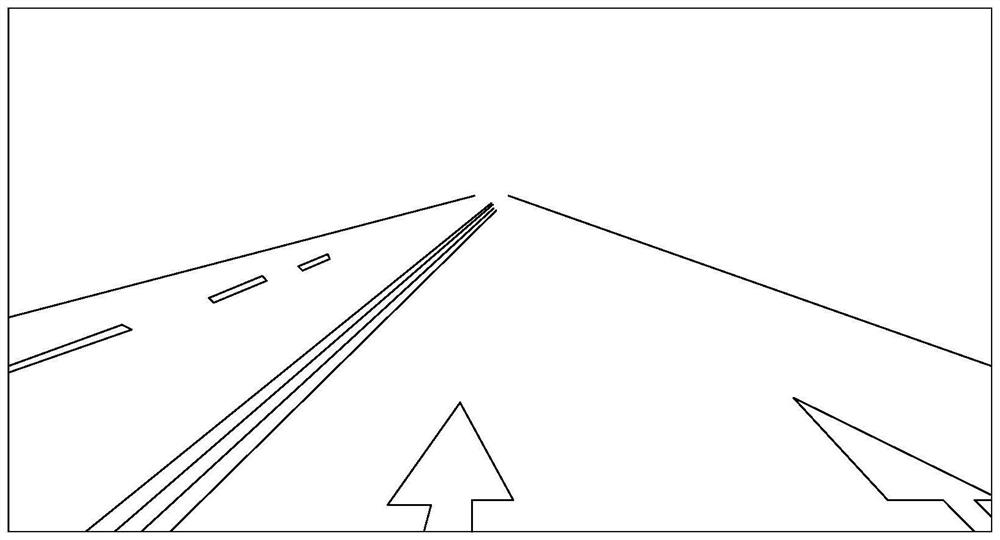
A map update, high-precision technology, applied in database update, image enhancement, image analysis, etc., can solve problems such as perspective deformation of road lane markings on the ground, low accuracy of high-precision map update, etc.

Active Publication Date: 2021-08-27
武汉四维图新科技有限公司
View PDF8 Cites 1 Cited by
  • Summary
  • Abstract
  • Description
  • Claims
  • Application Information

AI Technical Summary

Problems solved by technology

[0004] However, the road images collected by the acquisition equipment on the crowdsourcing vehicles are usually from the driver's perspective, and t

Method used


Image

  • High-precision map updating method and equipment
  • High-precision map updating method and equipment
  • High-precision map updating method and equipment

Examples


Embodiment Construction

[0080] In order to make the purpose, technical solutions and advantages of the present invention clearer, the technical solutions in the present invention will be clearly and completely described below in conjunction with the accompanying drawings in the present invention. Obviously, the described embodiments are part of the embodiments of the present invention , but not all examples. Based on the embodiments of the present invention, all other embodiments obtained by persons of ordinary skill in the art without creative efforts fall within the protection scope of the present invention.

[0081] In the present invention, it should be explained that the terms "first" and "second" are only used for descriptive purposes, and should not be understood as indicating or implying relative importance. In addition, "at least one" means one or more, and "plurality" means two or more. "And / or" describes the association relationship of associated objects, indicating that there may be thre...


PUM


Abstract

The invention provides a high-precision map updating method and equipment. The method comprises the following steps: acquiring pose data of a to-be-processed image at an acquisition moment; according to vector data matched with the to-be-processed image in a high-precision map database, refining the pose data to obtain refined pose data; and according to the laser point cloud data in the high-precision map database and the refined pose data, updating a lane marking corresponding to the to-be-processed image in a high-precision map. Compared with the prior art that crowdsourcing vehicles collect road images and determine the geographical coordinates of the lane markings by adopting binocular/monocular distance measurement based on the road images, the method has the advantages that the perspective deformation degree of the collected images is reduced by introducing the aerial photography technology; and the three-dimensional coordinates of the lane marking are determined based on the vector data and the laser point cloud data in the high-precision map database, so that the coordinate precision can be improved, and the precision of the high-precision map can be further improved.

Description

technical field [0001] The invention relates to the field of automatic driving, in particular to a method and device for updating a high-precision map. Background technique [0002] Compared with ordinary electronic maps, high-precision maps have the characteristics of higher precision and more data dimensions. In terms of accuracy, high-precision maps can be accurate to the centimeter level; in terms of dimensions, high-precision maps not only contain road information, such as: lane markings, lane types, lane widths, lane slopes, and lane curvatures; they also include traffic-related surrounding static Information such as: traffic signs, traffic lights, lane height limits, sewer crossings, obstacles and other road details. High-precision maps are the basis for safe driving of self-driving cars, and it is very important to ensure the freshness of high-precision maps. [0003] In terms of updating the lane markings on the high-precision map, the existing technology is as fo...

Claims


Application Information

Patent Timeline
IPC IPC(8): G06F16/29G06F16/23G06T7/70G06T7/33G06T7/181G06T5/00
CPCG06F16/29G06F16/23G06T7/70G06T7/33G06T7/181G06T5/006Y02D10/00
Inventor 吕枘蓬章丽萍曹亮龚壮壮
Owner 武汉四维图新科技有限公司
Why Eureka
Try Eureka