Method for assisting block adjustment by using Gaofen-7 laser height measurement data

An auxiliary area and network adjustment technology, applied in the field of satellite data processing, to achieve the effect of improving geometric accuracy and elevation accuracy

Active Publication Date: 2021-10-22
自然资源部国土卫星遥感应用中心
View PDF5 Cites 0 Cited by
  • Summary
  • Abstract
  • Description
  • Claims
  • Application Information

AI Technical Summary

Problems solved by technology

[0003] The purpose of the present invention is to provide a method of using Gaofen No. 7 laser alti

Method used


Image

  • Method for assisting block adjustment by using Gaofen-7 laser height measurement data
  • Method for assisting block adjustment by using Gaofen-7 laser height measurement data
  • Method for assisting block adjustment by using Gaofen-7 laser height measurement data

Examples


Embodiment 1

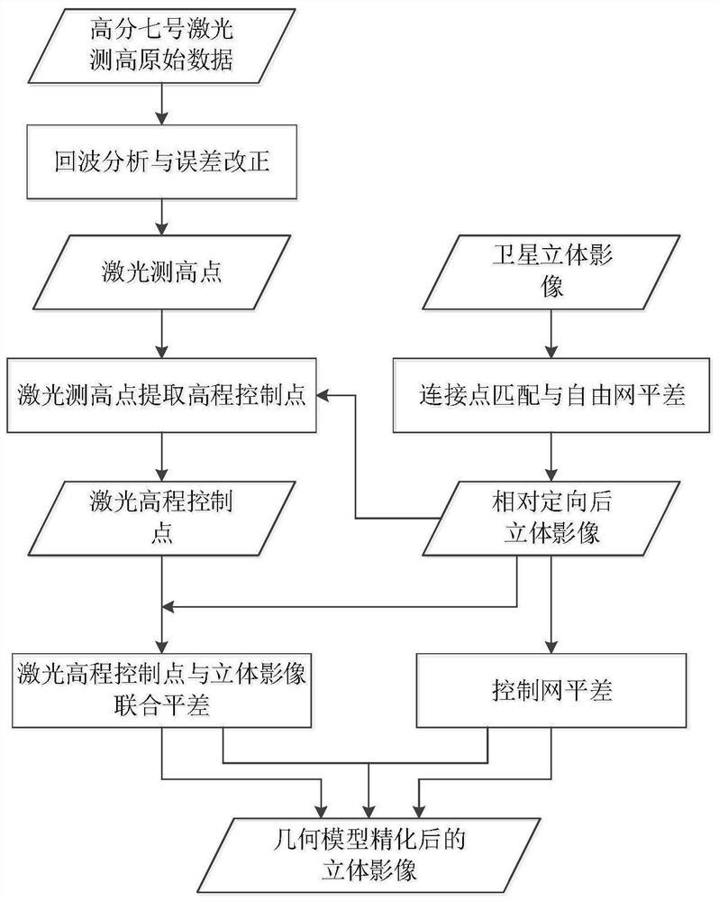
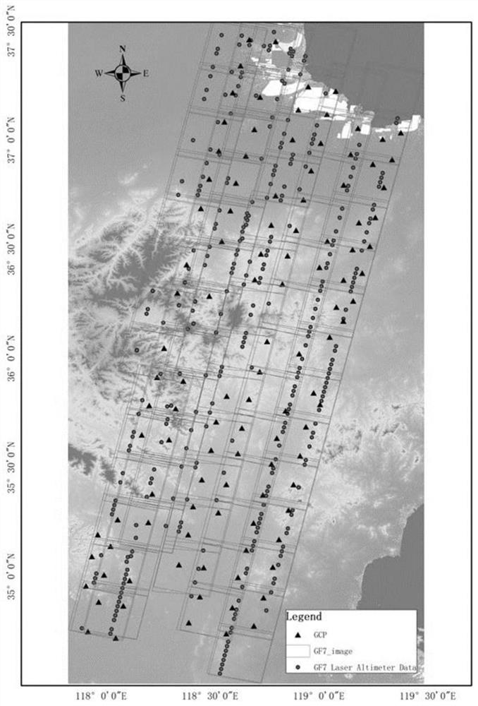
[0068] This embodiment provides a method for using Gaofen-7 laser altimetry data to assist in regional network adjustment, such as figure 1 shown, including the following steps:

[0069] S1, using Gaofen No. 7 laser altimetry system to obtain the original data of laser altimetry, after a series of fine correction processes, a usable standard laser altimetry product is formed, including the three-dimensional coordinates of the laser altimetry point, the footprint image and the laser altimeter measurement. High point footprint image image point coordinates;

[0070] S2, construct an area network from the acquired stereo images, and match the connection points to obtain sufficient and evenly distributed connection points, and carry out a free network adjustment based on the rational function model, so as to achieve high-precision relative orientation of the area network image, and obtain relative orientation. The post-stereoscopic image;

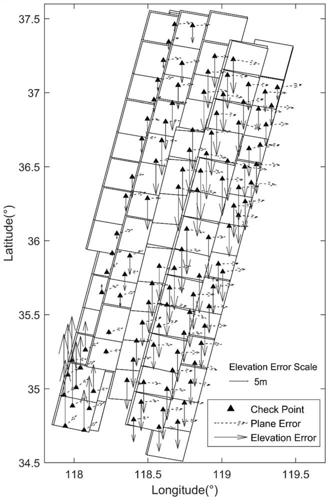
[0071] S3, according to the three-dime...


PUM


Abstract

The invention discloses a method for assisting block adjustment by using Gaofen-7 laser height measurement data, which combines Gaofen-7 laser height measurement data footprint images, realizes automatic extraction of elevation control points based on laser height measurement data, establishes a combined block adjustment model of laser height measurement data assisted stereoscopic images, model unification under the conditions of no control, field control and elevation control is realized; and laser height measurement data is used as elevation control to be applied to adjustment calculation, so that the geometric accuracy of the regional image is improved. According to the method provided by the invention, the elevation precision of the block can be greatly improved only by using laser height measurement data as elevation control in areas covering different terrain types.

Description

technical field [0001] The invention relates to the technical field of satellite data processing, in particular to a method for using Gaofen-7 laser altimetry data to assist regional network adjustment. Background technique [0002] Improving the adjustment accuracy of regional networks with few or even no ground control points is one of the core issues to achieve high-precision mapping in difficult areas of overseas and field measurement and control, and it is also a major technical difficulty. The laser altimetry data of Gaofen-7 has extremely high elevation accuracy, and is acquired synchronously with the stereo image, with similar error characteristics and high relative accuracy. A three-dimensional image joint regional network adjustment method aided by the laser altimetry data of the Gaofen-7 satellite. SUMMARY OF THE INVENTION [0003] The purpose of the present invention is to provide a method for using the Gaofen-7 laser altimetry data to assist the regional netw...

Claims


Application Information

Patent Timeline
IPC IPC(8): G01C5/00G06T3/00G06T5/00G06T7/521
CPCG01C5/00G06T3/0006G06T5/006G06T7/521
Inventor 唐新明刘昌儒李鸿洲薛白李国元王霞王洋洋
Owner 自然资源部国土卫星遥感应用中心
Why Eureka
Try Eureka