Two-dimensional code, laser radar and IMU (Inertial Measurement Unit) fusion positioning system and method without GPS (Global Positioning System) signal

A technology of GPS signal and laser radar, which is applied in the field of navigation and positioning, can solve the problem that the actual position of the vehicle is difficult to locate accurately, and achieve the effect of low production cost, guaranteed accuracy and high precision

Active Publication Date: 2022-03-18
WUHAN UNIV OF TECH
View PDF15 Cites 3 Cited by
  • Summary
  • Abstract
  • Description
  • Claims
  • Application Information

AI Technical Summary

Problems solved by technology

The patent application locates the actual position of the vehicle by comparing the spatial feature information detected in the actual underground environment during the mi

Method used


Image

  • Two-dimensional code, laser radar and IMU (Inertial Measurement Unit) fusion positioning system and method without GPS (Global Positioning System) signal
  • Two-dimensional code, laser radar and IMU (Inertial Measurement Unit) fusion positioning system and method without GPS (Global Positioning System) signal
  • Two-dimensional code, laser radar and IMU (Inertial Measurement Unit) fusion positioning system and method without GPS (Global Positioning System) signal

Examples


Embodiment Construction

[0042] The technical solutions of the various embodiments of the present invention will be clearly and completely described below in conjunction with the accompanying drawings. Apparently, the described embodiments are only some of the embodiments of the present invention, not all of them. Based on the embodiments of the present invention, all other embodiments obtained by persons of ordinary skill in the art without making creative efforts fall within the protection scope of the present invention.

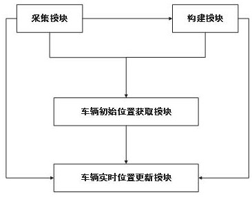
[0043] On the one hand, the present invention provides a two-dimensional code, laser radar and IMU fusion positioning system without GPS signal to solve the problem that satellite navigation cannot be used in the environment without GPS signal, the initial position of the vehicle cannot be determined, and the absolute position cannot be obtained by inertial navigation. Inertial navigation equipment errors accumulate over time and other issues.

[0044] like figure 1 As shown, the...


PUM


Abstract

The invention discloses a two-dimensional code, laser radar and IMU fusion positioning system and method without a GPS signal, and the method comprises the steps: taking a pre-collected high-precision map as a reference, carrying out the joint calibration of a camera, the laser radar and the IMU, and obtaining the initial position of a vehicle on the high-precision map through the recognition of a two-dimensional code and the combination of the detection distance of the laser radar; in the moving process, the IMU serves as a main part, the laser radar serves as an auxiliary part, navigation parameters calculated by the IMU are corrected through position data detected by the laser radar, then the navigation parameters, laser radar point cloud data and lane line images are matched with a high-precision map, and updating of the real-time position of the vehicle is completed. According to the method, the problem that the initial position of the unmanned vehicle cannot be determined in a GPS-signal-free environment is solved, inertial navigation accumulative errors are corrected through multi-sensor data fusion in the movement process, the reliability, stability and precision of a positioning system are improved, and the method can be widely applied to various scenes such as mines and indoor and underground scenes with weak GPS signals.

Description

technical field [0001] The invention relates to the technical field of navigation and positioning, in particular to the navigation and positioning of an unmanned vehicle in an underground scene, specifically a two-dimensional code, laser radar and IMU fusion positioning system and method without GPS signals. Background technique [0002] At present, outdoor navigation and positioning technology has developed relatively mature. For example, Global Navigation Satellite System (GNSS) can provide accurate geographical location, driving speed and other information in outdoor scenes, which brings great benefits to people's daily life. convenience. However, in indoor or underground environments without GPS (Global Position System, Global Positioning System) signals, GNSS cannot provide reliable and continuous positioning services due to obstacles. With the increasing demand for indoor and underground environments without GPS signals in our country, such as indoor navigation, indoo...

Claims


Application Information

Patent Timeline
IPC IPC(8): G01C21/16G01S17/86G01S17/89
CPCG01C21/1652G01C21/1656G01S17/86G01S17/89
Inventor 陈志军汪鹏飞吴超仲钱闯吴曦曦
Owner WUHAN UNIV OF TECH
Why Eureka
Try Eureka