
Landform condition measurement method and device
A topography and state technology, applied in geographic information database, image data processing, structured data retrieval, etc., can solve unfavorable development and utilization of natural resources, precise implementation of ecological environment protection and restoration, lack of quantitative analysis and evaluation of topography and topography, etc. question
Patent Information
- Authority / Receiving Office
- CN · China
- Patent Type
- Applications(China)
- Current Assignee / Owner
- Publication Date
- 2022-01-11
Smart Images
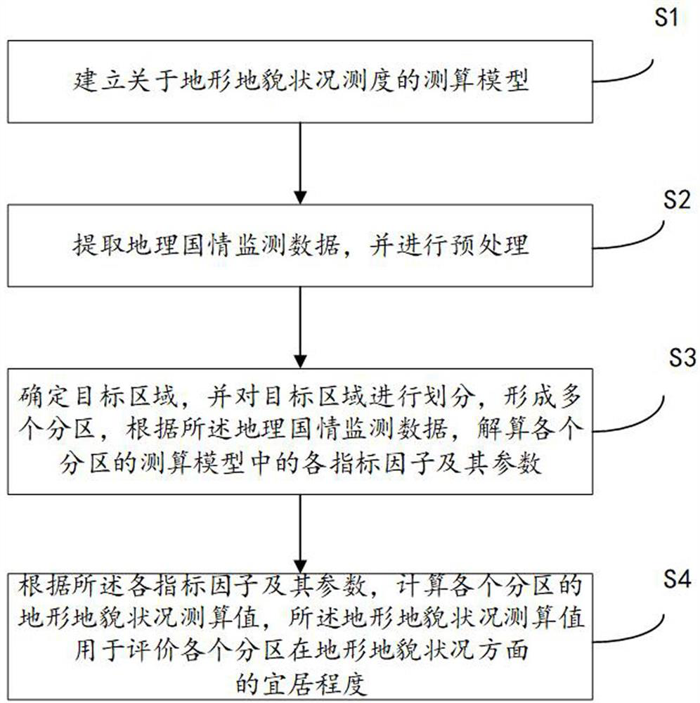
Figure 1 
Figure 2 
Figure 3
Abstract
Description
technical field
[0001] The invention relates to the technical field of geographic information processing, in particular to a method and device for measuring terrain and geomorphic conditions. Background technique
[0002] Human beings and the natural environment are interdependent and utilize each other, and human beings are not only the creators of the environment, but also the creators of the environment. Atmosphere, water body, soil and biological world are the four natural environmental elements on which human beings depend, and they are inextricably linked with topography.
[0003] High altitude is often accompanied by low pressure, low oxygen, cold, dryness, and strong ultraviolet rays. The rocky surface and lack of soil in the area greatly increase the difficulty of natural vegetation reproduction and artificial cultivation. Surface undulations, slopes, and slope aspects have a profound impact on agricultural production. Flat surfaces are conducive to mechanical oper...
Examples
Embodiment Construction
[0044] In order to better understand the above-mentioned technical solution, the above-mentioned technical solution will be described in detail below in conjunction with the accompanying drawings and specific implementation methods.
[0045] refer to figure 1 , in some embodiments, a method for measuring and processing terrain and geomorphic conditions is provided, including:
[0046] S1. Establishing a calculation model for the measurement of terrain and landform conditions;
[0047] S2. Extracting geographical national conditions monitoring data and performing preprocessing;
[0048] S3. Determine the target area, and divide the target area to form multiple partitions, and calculate the index factors and their parameters in the measurement model of each partition according to the geographical national conditions monitoring data;
[0049] S4. According to the above-mentioned index factors and their parameters, calculate the estimated topographic and geomorphic conditions of...