Map display method and system and mobile terminal

A mobile terminal and display method technology, applied in the directions of maps/plans/charts, telephone communication, instruments, etc., can solve the problems of insufficient map display, low reading efficiency, blurry screen, etc., so as to improve user experience and solve screen flickering. , the effect of improving efficiency

Inactive Publication Date: 2011-04-13
融创天下(上海)科技发展有限公司
View PDF6 Cites 20 Cited by
  • Summary
  • Abstract
  • Description
  • Claims
  • Application Information

AI Technical Summary

Problems solved by technology

[0007] The purpose of the embodiment of the present invention is to propose a method, system and mobile terminal for map display, aiming to solve the problems of map display not smooth enough, low reading efficiency, flickering screen, and blurred screen in the prior art

Method used


Image

  • Map display method and system and mobile terminal
  • Map display method and system and mobile terminal
  • Map display method and system and mobile terminal

Examples


Embodiment 1

[0031] Figure 4 It is an overall flow chart of a map display method in an embodiment of the present invention. Described method comprises the following steps:

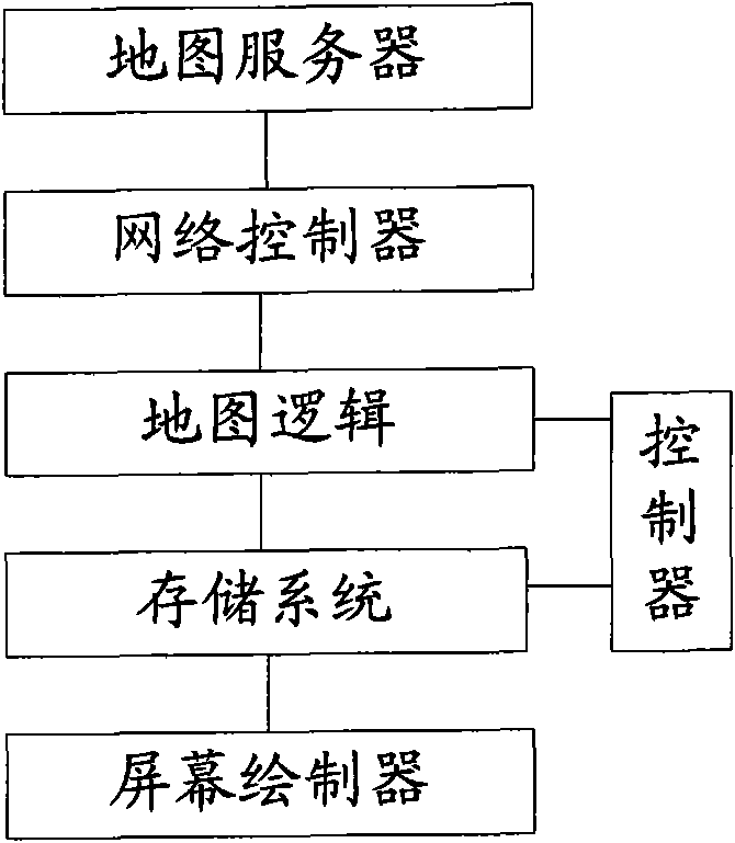
[0032] S401, preset the size and moving distance of the cutout and screen buffer, divide the mobile terminal screen, screen buffer, and canvas into cutouts, the cutouts have magnification levels and central coordinate attributes, and determine the mobile terminal screen and screen buffer The relative position of the area and the canvas;

[0033] The unit of the cut picture, the screen buffer, and the moving distance is pixel, and the cut picture includes three attributes: zoom level, center coordinate, the zoom level is a defined attribute of the electronic map itself, and the center coordinate refers to selecting a certain The latitude and longitude coordinates of a geographic location are used as the reference origin. At a certain zoom level, the electronic map is divided into multiple cutouts according to the siz...

Embodiment 2

[0050] Figure 5 It is the first specific flow chart of a map display method according to the embodiment of the present invention. Described method comprises the following steps:

[0051] S501, preset the size and moving distance of the cutout and screen buffer, divide the mobile terminal screen, screen buffer, and canvas into cutouts, the cutouts have magnification level and center coordinate attributes, and determine the mobile terminal screen and screen buffer The relative position of the area and the canvas;

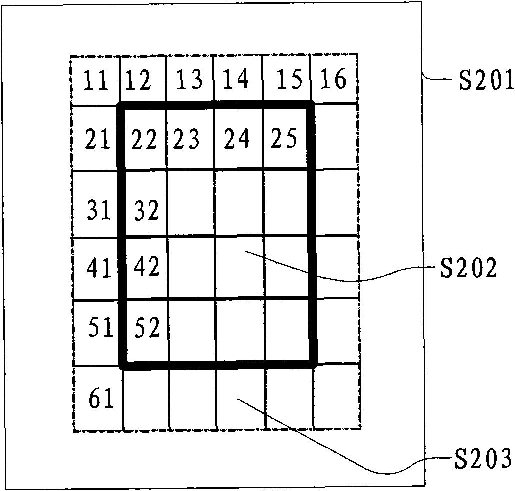
[0052] S502. When a trigger instruction is received, calculate a first number N of slices that need to be drawn on the canvas, and store the first number N and attributes of the slices into a first set of slices;

[0053] S503, judging whether the cut graph in the first cut graph set exists locally through the cut graph attribute; if so, execute step S505; otherwise, execute step S504;

[0054] S504, and obtain the cut image not stored locally from the remote serv...

Embodiment 3

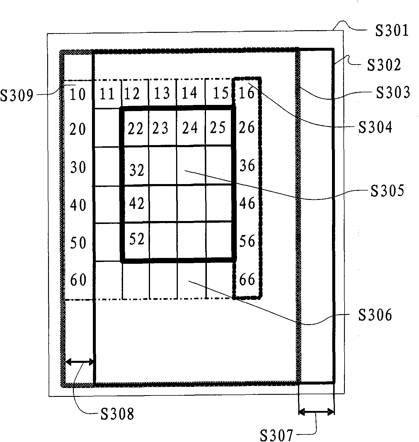
[0059] Image 6 It is the second specific flow chart of a map display method according to the embodiment of the present invention. This embodiment calculates the first number N of the cut graphs that need to be drawn on the canvas and the cut graph attributes are stored in the first cut graph set, and the first parameter n and the second parameter t (n and t are both integers) are defined; judge one by one Whether the cutouts in the first cutout set exist locally, if yes, read the locally saved cutouts into the memory and draw them to the coordinate points corresponding to the canvas; judge whether n is equal to N, if so, draw the canvas on the screen Buffer, displayed on the mobile terminal screen.

[0060] Described method comprises the following steps:

[0061] S601, preset the size and moving distance of the cutout and screen buffer, divide the mobile terminal screen, screen buffer, and canvas into cutouts, the cutouts have magnification level and center coordinate attri...


PUM


Abstract

The invention discloses a map display method, a map display system and a mobile terminal. The method comprises the following steps of: presetting the size of cut maps and a screen buffer area and movement distance according to the performance of mobile terminal equipment, dividing a mobile terminal screen, the screen buffer area and picture cloth into cut maps, and determining relative positions;calculating first number N of the cup maps to be drawn on the picture cloth, storing cup map attributes into a first cup map set, and defining a first parameter n and a second parameter t; judging the cut maps in the first cut map set exist locally one by one, if so, reading the locally stored cut maps to an internal memory and drawing the cut maps at corresponding coordinate points of the picture cloth; and judging whether n is equal to N, if so, drawing the picture cloth on the screen buffer area, and displaying on a screen of the mobile terminal. Phenomena of a splash screen and a blurred screen when the maps are displayed on the screen of the mobile terminal are avoided, the speed of displaying the maps and user experience are improved and the network flow is saved.

Description

technical field [0001] The present invention relates to the map field, in particular to a map display method, system and mobile terminal. Background technique [0002] With the continuous progress and development of society, people's demand for various information information is becoming more and more comprehensive. Products based on electronic maps (belonging to geographic information system (GIS)) bring great convenience to people's travel. Therefore, it is meaningful to implement electronic maps on various terminal devices. Looking at the current electronic map products on mobile terminals, there are no more than the following two usage methods: [0003] The first method: displaying a web page embedded with a map object or component through a mobile phone wap or a web browser; [0004] The second type: an independent application to display the map; [0005] Figure 1 It is a structural diagram of the map display system in the prior art. The user triggers a UI (User Int...

Claims


Application Information

Patent Timeline
Patent Type & Authority Applications(China)
IPC IPC(8): G06F17/30
CPCG09B29/106G01C21/367H04M1/72544H04M1/72427
Inventor 宋叶祥关则京
Owner 融创天下(上海)科技发展有限公司
Why Eureka
Try Eureka