Method for estimating vegetation covering-managing factors of soil erosion by remote sensing

A technology of vegetation coverage and management factors, applied in computing, image data processing, electrical digital data processing, etc., can solve the problems of limited application, difficulty in obtaining optical remote sensing images, etc., and achieve the effect of good versatility and reasonable estimation results

Active Publication Date: 2015-04-01
艺佳设计集团有限公司
View PDF2 Cites 0 Cited by
  • Summary
  • Abstract
  • Description
  • Claims
  • Application Information

AI Technical Summary

Problems solved by technology

However, for cloudy and rainy areas (for example, southern China), it is generally difficult to obtain multi-period cloud-free optical remote sensing images
This greatly limits the application of the above methods in southern China.

Method used


Image

  • Method for estimating vegetation covering-managing factors of soil erosion by remote sensing
  • Method for estimating vegetation covering-managing factors of soil erosion by remote sensing
  • Method for estimating vegetation covering-managing factors of soil erosion by remote sensing

Examples


Embodiment Construction

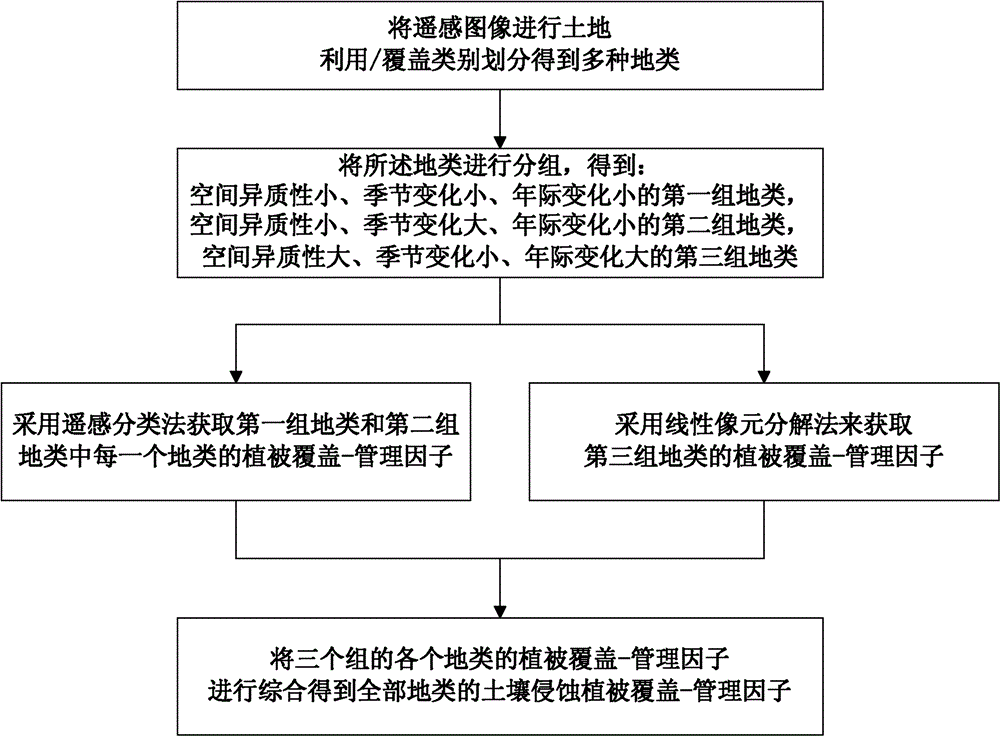
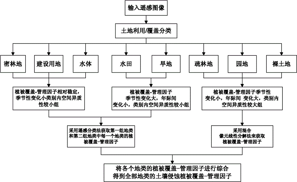
[0033] Such as figure 1 As shown, the implementation steps of the remote sensing estimation method of soil erosion vegetation coverage-management factors in this embodiment are as follows:

[0034]1) Divide remote sensing images into land use / cover categories to obtain multiple land types; group the obtained multiple land types to obtain the first group of land types with small spatial heterogeneity, small seasonal variation, and large interannual variation , the second group of land types with small spatial heterogeneity, large seasonal variation, and small interannual variation, and the third group of land types with large spatial heterogeneity, small seasonal variation, and large interannual variation;

[0035] 2) Obtain the vegetation coverage-management factor of each land type in the first group of land types and the second group of land types by using the remote sensing classification method;

[0036] 3) Decompose the remote sensing image into linear spectrum mixed pix...


PUM


Abstract

The invention discloses a method for estimating vegetation covering-managing factors of soil erosion by remote sensing, which includes the following steps of 1) classifying remote-sensing images to obtain multiple types of soil and dividing the multiple types of soil into three groups according to spatial heterogeneity and the characteristics changed with time of the types of the soil; 2) acquiring the vegetation covering-managing factors of the first group and the second group of the types of the soil by means of remote-sensing classifying; 3) performing linear-spectrum mixed pixel unmixing on the remote sensing images to obtain a green-vegetation component chart, a soil component chart and a shadow / water component chart, computing to obtain the vegetation covering-managing factor of the third group of the types of the soil according to the formula C=F soil / (1+F green vegetation+F shadow); 4) integrating the vegetation covering-managing factors of the three groups of the types of the soil to obtain the vegetation covering-managing factors of soil erosion of all the soil, wherein the F soil is soil component, the F green vegetation is green vegetation component. The method for estimating vegetation covering-managing factors of soil erosion by remote sensing has the advantages of reasonable estimating results and high universality.

Description

technical field [0001] The invention relates to the field of soil erosion risk assessment, in particular to a remote sensing estimation method suitable for soil erosion vegetation coverage-management factors. Background technique [0002] Soil erosion refers to the movement of soil out of the soil due to water erosion or wind force, resulting in a decline in soil fertility, serious or even complete loss of soil fertility. The demise of the ancient Babylonian kingdom was caused by soil erosion and environmental damage. In the early 1930s, serious soil erosion also occurred in the United States. However, the government, all social strata and the public have attached great importance to it and taken strong soil and water conservation measures, which have well controlled soil erosion. Soil erosion is very serious in our country. The Yellow River Basin is the most obvious example. Huge sediment flows from the Gobi, grasslands, and Loess Plateau into the Yellow Sea along with t...

Claims


Application Information

Patent Timeline
Patent Type & Authority Patents(China)
IPC IPC(8): G06F19/00G06T7/00
Inventor 吴嘉平江振蓝苏世亮
Owner 艺佳设计集团有限公司
Why Eureka
Try Eureka