Region-division-based spatial complex horizon reconstruction method

A technology of area division and space, applied in image data processing, 3D modeling, instruments, etc., to achieve the effect of ensuring fast display, ensuring accuracy, and eliminating manual editing

Inactive Publication Date: 2013-01-09
UNIV OF ELECTRONICS SCI & TECH OF CHINA
View PDF2 Cites 15 Cited by
  • Summary
  • Abstract
  • Description
  • Claims
  • Application Information

AI Technical Summary

Problems solved by technology

[0027] In order to overcome the above-mentioned shortcomings of the prior art, the present invention provides a spatially complex horizon reconstruction method based on region division. By dividing overlapping subregions, complex terrain such as multiple fault overlaps can be solved without the need for fault polygons. The level reconstruction problem in 3D geological modeling under certain conditions; at the same time, through the interpolation method of mixed grid, the dynamic control of the standard grid spacing is realized, so that the geological structure can be finely expressed, and the reconstructed geological layer plane and faults are strictly closed, which is convenient for processing in later geological modeling, such as block processing

Method used


Image

  • Region-division-based spatial complex horizon reconstruction method
  • Region-division-based spatial complex horizon reconstruction method
  • Region-division-based spatial complex horizon reconstruction method

Examples


Embodiment Construction

[0055] First define some basic geological structures and scheme terms:

[0056] Horizon: Refers to a specific position in a stratigraphic sequence.

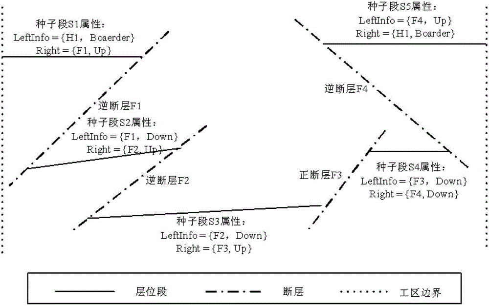
[0057] Fault: After the rock mass is fractured by force, the rock blocks on both sides have significant displacement along the fracture surface.

[0058] Segment data: A data set consisting of a continuous set of discrete points on a section of a horizon or fault.

[0059] Hanging wall of a fault: Located above the fault plane.

[0060] Fault footwall: located below the fault plane.

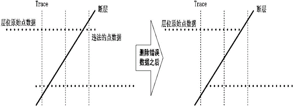
[0061] Stratigraphic pinch-out: refers to the sedimentary layer towards the edge of the sedimentary basin, and its thickness gradually becomes thinner until there is no deposition.

[0062] Gridding: Logically divide the discrete point data to form a regular logical grid, which is convenient for horizon interpolation.

[0063] Interpolation: The process of using known points to calculate unknown points.

[0064] Fitting: A process of using the ...


PUM


Abstract

The invention discloses a region-division-based spatial complex horizon reconstruction method. The horizon reconstruction in three-dimensional geological modeling under the complex topography conditions such as multi-fault overlapping can be realized without the needing of a fault polygon; simultaneously, the dynamic control of specified grid spacing is realized by a hybrid grid interpolation method, so that a geologic structure can be expressed finely; the reconstructed geologic horizon surface and the fault are closed strictly; and the processing, such as blocking processing, in later geological modeling is facilitated.

Description

technical field [0001] The invention belongs to the technical field of geological modeling, in particular to a method for reconstructing complex spatial horizons based on region division. Background technique [0002] Geological modeling is to process limited geological data through certain technical means on the computer to reproduce the geological structure model. The essence is to transform the limited discrete space sample point data into a continuous and visible geological surface or geological body, in which layer reconstruction is the key. The most important methods of level reconstruction are the interpolation method and the model structure of the level. [0003] Interpolation is to use the method of surface fitting to establish a continuous function through discrete input sampling points, and use this reconstructed function to find the function value at any position. Horizontal reconstruction is a method of discretely reconstructing surfaces in a limited three-dim...

Claims


Application Information

Patent Timeline
Patent Type & Authority Applications(China)
IPC IPC(8): G06T17/05
Inventor 鲁才李光友胡光岷
Owner UNIV OF ELECTRONICS SCI & TECH OF CHINA
Why Eureka
Try Eureka