Mountainous village and town construction land suitability assessment method based on geological disaster

A technology of construction land and suitability, applied in special data processing applications, instruments, calculations, etc., can solve the problems of incompleteness, factors and indicators of geological disasters that have not been fully considered, and achieve the purpose of avoiding the differentiation of human factors and avoiding geological disasters. Disasters, the effect of satisfying reliability

Inactive Publication Date: 2014-02-26
CHONGQING UNIV
View PDF2 Cites 4 Cited by
  • Summary
  • Abstract
  • Description
  • Claims
  • Application Information

AI Technical Summary

Problems solved by technology

At present, in the evaluation of the suitability of land for construction, geological and geomorphic factors are also considered, but they are not comprehensive, or the factors and indicators that are likely to cause geological disasters are not fully considered.

Method used


Image

  • Mountainous village and town construction land suitability assessment method based on geological disaster
  • Mountainous village and town construction land suitability assessment method based on geological disaster
  • Mountainous village and town construction land suitability assessment method based on geological disaster

Examples


Embodiment 1

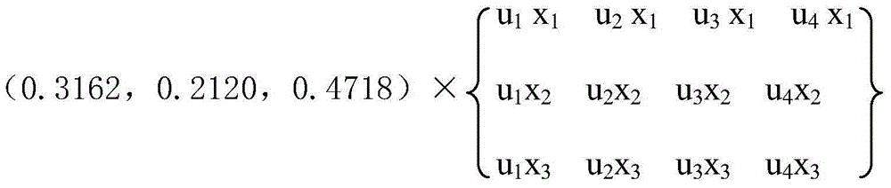
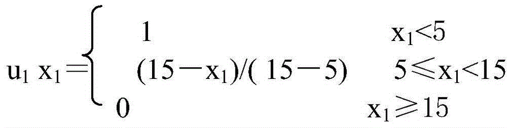
[0037] A method for evaluating the suitability of construction land for villages and towns in mountainous areas based on earthquake risks, characterized in that: conducting field surveys on the topographic and geomorphic conditions 100 of construction land for villages and towns in mountainous areas to be evaluated. The survey indicators of the topographic and geomorphic conditions 100 include: site slope 101 , site slope aspect 102 and site geomorphic type 103 .

[0038] 1.1) The site slope 101 is expressed in degrees, and its suitability grading rules are: [0, 5) for high suitability, [5, 15) for moderate suitability, [15, 55) for poor suitability, and [15, 55) for extreme suitability. The difference is greater than or equal to 55.

[0039]By surveying, the site slope 101 of the mountain village and town construction land to be evaluated is x 1 , combined with the above-mentioned site slope 101 suitability classification rules, determine the site slope 101 suitability membe...

Embodiment 2

[0081] In this embodiment, four first-level indicators are considered: 100 topographic conditions, 200 geological conditions, 300 hydrological conditions, and 400 ecological environment conditions. There are several second-level indicators under each first-level indicator. Thus, the suitability of construction land for villages and towns in mountainous areas to be evaluated can be obtained. The suitability classification and weight of this embodiment are shown in Table 1:

[0082] Table 1 The weight and suitability analysis of the evaluation indicators affecting the suitability of construction land in villages and towns in mountainous areas

[0083]

[0084]

[0085]

[0086]

[0087] The surveying method of each index in this embodiment is the same as that of the prior art, and the steps and idea of ​​data processing (including the membership function) are the same as those in Embodiment 1. Specifically, the survey results are divided into three situations:

[...

Embodiment 3

[0229] In this example, the suitability evaluation of a place in Chongkan Town, Tongnan County will be carried out. The landform type is middle hilly landform, and this land will be used as land for new rural construction. Its suitability was evaluated according to the aforementioned theoretical framework.

[0230] (1) Topographic factors

[0231] The overall average slope of the site is 4°, and the slope of the site faces east.

[0232] (2) Geological factors

[0233] There are potential landslides around the site. There are no faults in the landslide body, and there is no higher free surface in the lower part of the landslide body. The valley on the slope is cut into a V shape with a high degree of cutting. The geological survey report has the following description: the degree of rock weathering is high, and the slope is mainly composed of purple-gray medium and thick layered mudstone. The mudstone is completely and strongly weathered. Massive structure and strip struc...


PUM


Abstract

The invention aims at providing a method for obtaining suitability degree of mountainous village and town construction land, provides reference data for mountainous planning and construction and discloses a mountainous village and town construction land suitability assessment method based on geological disaster. The method includes comprehensively utilizing a fuzzy synthetic evaluation method, a Delphi method, an onsite statistical survey method and the like according to the theories of fuzzy mathematics and probability statistics, analyzing and calculating factor weight affecting the suitability of the mountainous village and town construction land and the membership degree of indexes to further obtain the relation between the affecting indexes of each stage and the suitability evaluation grades according to calculation. Analysis of a project case shows that dynamic suitability evaluation based on the geological disaster can be conducted on the suitability of the mountainous village and town construction land, a preferable technical scheme can be provided during address selection, and life property loss caused by damage of the geological disaster to the village and town construction land in the use process can be avoided.

Description

technical field [0001] The invention relates to the field of disaster prevention, in particular to the prediction and evaluation of the suitability of construction land for villages and towns in mountainous areas. Background technique [0002] The factors that need to be considered in the construction of villages and towns in mountainous areas and the construction of villages and towns in plain areas are very different. In plain areas, the suitability evaluation of village and town construction land is mainly based on ecological environment, social economy and other factors, while the characteristics of village and town construction land in mountainous areas determine the index system and evaluation method of its suitability evaluation has its own characteristics. Geological disasters are an important factor that affects the production, life and personal safety of the people in mountainous areas, and seriously hinders the economic construction and social development of villa...

Claims


Application Information

Patent Timeline
Patent Type & Authority Applications(China)
IPC IPC(8): G06F19/00
Inventor 陈红军孙斌王桂林
Owner CHONGQING UNIV
Why Eureka
Try Eureka