MODIS data-based agricultural drought remote sensing monitoring method

A technology of remote sensing monitoring and drought situation, applied in the field of remote sensing technology application, can solve the problems of insufficient drought monitoring means, untimely grasp of drought situation, difficulty in comprehensive and objective drought evaluation, etc.

Inactive Publication Date: 2014-08-20
JIANGSU WATER CONSERVANCY SCI RES INST
View PDF4 Cites 53 Cited by
  • Summary
  • Abstract
  • Description
  • Claims
  • Application Information

AI Technical Summary

Problems solved by technology

However, the current drought resistance work in Huaibei, Jiangsu Province has problems such as insufficient drought monitoring methods, untimely grasp of drought conditions, and difficult to achieve comprehensive and objective drought evaluation.

Method used


Image

  • MODIS data-based agricultural drought remote sensing monitoring method
  • MODIS data-based agricultural drought remote sensing monitoring method
  • MODIS data-based agricultural drought remote sensing monitoring method

Examples


Embodiment Construction

[0081] The present invention will be further described below in conjunction with the accompanying drawings and embodiments.

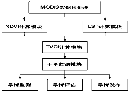
[0082] Such as figure 1 As shown, a remote sensing monitoring method for agricultural drought based on MODIS data, taking the drought monitoring in Huaibei region of Jiangsu Province as an example, the latitude and longitude range is 116°01′~120°08E, 32°06′~35°13′N. The study area is dominated by plains, with a few mountains in the north. The main surface types include agricultural land, agricultural land / natural vegetation, sparse vegetation, grassland, urban and built-up areas, permanent wetlands, and water bodies. According to statistics, dry-planted crops in Huaibei, Jiangsu Province are mainly winter wheat, which are distributed in Xuzhou, Lianyungang, Suqian, Huai'an, and Yancheng. Therefore, a monitoring study was carried out on the drought conditions in the winter wheat planting areas of these five cities.

[0083] Firstly, the MODIS data of t...


PUM


Abstract

The invention discloses a MODIS data-based agricultural drought remote sensing monitoring method. The MODIS data-based agricultural drought remote sensing monitoring method comprises the following steps of acquiring soil actual measurement data of a zone to be monitored, building a functional relationship formula of the soil actual measurement data and a temperature vegetation dryness index for earth surface drought characterization, calculating soil weight water content by the functional relationship formula and the MODIS data of the zone to be monitored, and determining a drought level according to the soil weight water content and acquiring an agricultural drought monitoring result. Through use of high MODIS remote sensing data time resolution, farmland drought monitoring is realized. The MODIS data-based agricultural drought remote sensing monitoring method utilizes a remote sensing technology to realize farmland drought dynamic monitoring. A practical application test proves that the MODIS data-based agricultural drought remote sensing monitoring method is simple and efficient, can be operated easily, has an accurate result and can be widely used for farmland drought monitoring.

Description

technical field [0001] The invention relates to the application field of remote sensing technology, in particular to a method for monitoring the degree of agricultural drought in various regions by using remote sensing technology, in particular to a remote sensing monitoring method for agricultural drought based on MODIS data. Background technique [0002] At present, the Huaibei area of ​​Jiangsu Province is located in the lower reaches of the Huaihe River. It is a north-south climate transition zone. The temporal and spatial distribution of rainfall and incoming water is uneven, and it is an area prone to floods and droughts. In recent years, agricultural meteorological droughts frequently broke out in spring and early summer in this region; for example, in the early summer of 2011, Huaibei experienced the most severe meteorological drought in the same period in 60 years. However, at present, the drought resistance work in the Huaibei area of ​​Jiangsu Province has problem...

Claims


Application Information

Patent Timeline
Patent Type & Authority Applications(China)
IPC IPC(8): G01N21/25
Inventor 王冬梅黄俊友鲍艳松谢义林梁文广王春美
Owner JIANGSU WATER CONSERVANCY SCI RES INST
Why Eureka
Try Eureka