Remote Sensing Monitoring Method of Agricultural Drought Based on MODIS Data
A technology for remote sensing monitoring and drought conditions, applied in the field of remote sensing technology applications, can solve the problems of untimely grasp of drought conditions, insufficient drought monitoring methods, and difficult to achieve comprehensive and objective drought evaluation
- Summary
- Abstract
- Description
- Claims
- Application Information
AI Technical Summary
Problems solved by technology
Method used
Image
Examples
Embodiment Construction
[0081] The present invention will be further described below in conjunction with the accompanying drawings and embodiments.
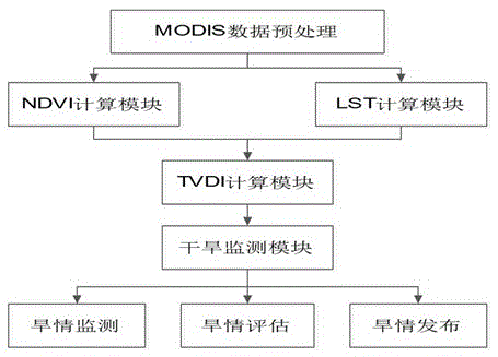
[0082] Such as figure 1 As shown, a remote sensing monitoring method for agricultural drought based on MODIS data, taking the drought monitoring in Huaibei region of Jiangsu Province as an example, the latitude and longitude range is 116°01′~120°08E, 32°06′~35°13′N. The study area is dominated by plains, with a few mountains in the north. The main surface types include agricultural land, agricultural land / natural vegetation, sparse vegetation, grassland, urban and built-up areas, permanent wetlands, and water bodies. According to statistics, dry-planted crops in Huaibei, Jiangsu Province are mainly winter wheat, which are distributed in Xuzhou, Lianyungang, Suqian, Huai'an, and Yancheng. Therefore, a monitoring study was carried out on the drought conditions in the winter wheat planting areas of these five cities.
[0083] Firstly, the MODIS data of t...
PUM
 Abstract
Description
Claims
Application Information
 - R&D
- Intellectual Property
- Life Sciences
- Materials
- Tech Scout
- Unparalleled Data Quality
- Higher Quality Content
- 60% Fewer Hallucinations
Browse by: Latest US Patents, China's latest patents, Technical Efficacy Thesaurus, Application Domain, Technology Topic, Popular Technical Reports.
© 2025 PatSnap. All rights reserved.Legal|Privacy policy|Modern Slavery Act Transparency Statement|Sitemap|About US| Contact US: help@patsnap.com


