MODIS data based agricultural drought monitoring method

A basic data and drought technology, applied in the agricultural field, can solve the problems of low data accuracy, neglect, and inability to provide effective guarantee for the classification of drought grades.

Inactive Publication Date: 2017-08-22
SHANDONG AGRI SUSTAINABLE DEV INST
View PDF10 Cites 18 Cited by
  • Summary
  • Abstract
  • Description
  • Claims
  • Application Information

AI Technical Summary

Problems solved by technology

[0003] To sum up, the problems existing in the existing technology are: the current technology only calculates the crop water supply index for the vegetation index and the surface temperature when monitoring the drought, while ignoring the MODIS image processing technology, so that the accuracy of data acquisition is low; Cannot provide effective guarantees for the establishment of a more standardized drought classification

Method used


Image

  • MODIS data based agricultural drought monitoring method
  • MODIS data based agricultural drought monitoring method
  • MODIS data based agricultural drought monitoring method

Examples


Embodiment Construction

[0086]为了使本发明的目的、技术方案及优点更加清楚明白,以下结合实施例,对本发明进行进一步详细说明。应当理解,此处所描述的具体实施例仅仅用以解释本发明,并不用于限定本发明。

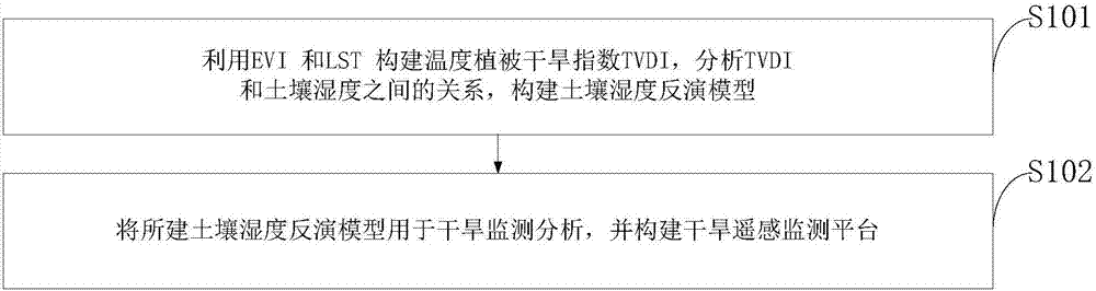
[0087]下面结合附图对本发明的应用原理作详细描述。

[0088]如图1所示,本发明实施例提供的基于MODIS数据的农业干旱监测方法,包括:

[0089]S101:利用EVI和LST构建温度植被干旱指数TVDI,分析TVDI和土壤湿度之间的关系,构建土壤湿度反演模型;

[0090]S102:将所建土壤湿度反演模型用于干旱监测分析,并构建干旱遥感监测平台;
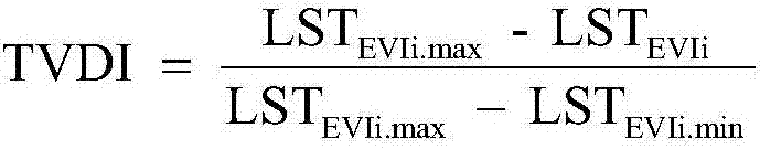
[0091]TVDI的计算模型为:

[0092]

[0093]LSTEVIi.max=a+bEVIi

[0094]LSTEVIi.min=a'+b'EVIi

[0095]采集一系列不同土壤水分含量的农田光谱、温度和水分数据,构建基础数据集;以此计算EVI-LST空间的干边与湿边,获取TVDI模型所需的参数a,b,a’,b’;

[0096]土壤湿度的计算包括作物供水指数的计算:

[0097]

[0098]式中VSWI为被监测农田地块所对应的各像元点的作物供水指数;EVI为被监测农田地块所对应的MODIS影像各像元点的增强植被指数;Ts为被监测农田地块所对应的遥感影像各像元点的地表温度;

[0099]所述MODIS影像各像元点的图像处理方法包括:

[0100]根据红外光谱辐射得到农田温度参数,红外光谱发射率在所选定的波长处与温度有近似相同的线性关系,即:

[0101]εi2=εi1[1+k(T2-T1)]

[0102]式中,εi1是波长为λi,温度为T1时的光谱发射率;εi2是波长为λi,温度为T2时的光谱发射率;T1、T2分别为两个不同时刻的温度;k为系数;

[0103]Vi1为第一个温度T1下的第i个通道的输出信号,Vi2为第一个温度T2下的第i个通道的输出信号,T1温度下的发射率εi1∈(0,1),通过随机选取一组εi1,由下式计算在参数εi1下实际得到的Ti1:

[0104]

[0105]设k∈(-η,η),通过随机选取一个k,在第二个温度T2下的发射率εi2的表达式为:

[0106]

[0107]由下式计算在参数εi1下实际得到的Ti2:

[0108]

[0109]所述MODIS布置有多个用于监测的影像无线传感器;所述影像无线传感器的调制信号x(t)的分数低阶模糊函数表示...


PUM


Abstract

The invention discloses MODIS data based agricultural drought monitoring method, and belongs to the technical field of agriculture. The characteristic that MODIS remote sensing is relatively high in time resolution is used to monitor drought of farmland; EVI and LST are used to construct a temperature vegetation drought index (TVDI), the relation between the TVDI and the soil humidity is analyzed, and a soil humidity inversion model is established; and the established soil humidity inversion module is used to drought monitoring and analyzing, and a drought remote-sensing monitoring platform is constructed. According to the invention, a remote-sensing technology is used for dynamic farmland drought monitoring, and practical application shows that the method is simple, high in efficiency, easy to operation and accurate in result and can be widely applied to farmland drought monitoring.

Description

technical field [0001] The invention belongs to the field of agricultural technology, in particular to an agricultural drought monitoring method based on MODIS data. Background technique [0002] The occurrence process of drought is latent and not easy to discover; the occurrence of drought in farmland is characterized by a wide range of influence, which brings serious catastrophic consequences and economic losses; research and evaluation of the process of occurrence and development of drought can take corresponding measures to combat drought and prevent disasters Disaster mitigation measures to reduce agricultural disaster losses. With the development of remote sensing technology, remote sensing has opened up a new way for drought monitoring with its dynamic, real-time, multi-spectral and cheap advantages. The vegetation index and surface temperature obtained by remote sensing are two very important parameters to describe the characteristics of the earth's surface. Therefo...

Claims


Application Information

Patent Timeline
Patent Type & Authority Applications(China)
IPC IPC(8): G06K9/00G06F17/50G06Q50/02
CPCG06Q50/02G06F30/20G06V20/188
Inventor 梁守真刘涛王猛王勇朱振林陈振侯学会
Owner SHANDONG AGRI SUSTAINABLE DEV INST
Why Eureka
Try Eureka