Extracting method for fixed star sensitive east and west parameters of stationary satellite imaging navigation and registration

A geostationary satellite, satellite remote sensing technology, applied in navigation, astronomical navigation, mapping and navigation, etc., can solve the problems of low accuracy, increase the error of feature points, and not describe the image data processing method, so as to improve the recognition accuracy and improve the accuracy. Effect

Active Publication Date: 2016-07-13
SHANGHAI SATELLITE ENG INST
View PDF8 Cites 13 Cited by
  • Summary
  • Abstract
  • Description
  • Claims
  • Application Information

AI Technical Summary

Problems solved by technology

[0003] In the process of constant center sensitivity, the effective projection of a star with a small brightness in the detector array may be smaller than the size of a pixel, and when the projection is completely inside a certain pixel, the single exposure data cannot be used to determine the star’s The specific position within this cell, which will lead to low accuracy of feature point extraction
In addition, the imaging process will be interfered by various random noises, which will increase the error of feature point extraction.
[0004] The NOAA research report (1989, No. N90-13422) written by J. LFiorello et al. introduced the concept and principle of image navigation registration, and proposed a method for obtaining instrument deformation parameters by observing stars with instruments, but did not elaborate on image navigation and registration. The processing method of data; U.S. Patent: Methodandapparatusforradiometerstarsensing (patent No. US4801202) has described the method for the radiometer of geostationary meteorological satellite to observe the star on orbit, discloses the technical scheme to specific operation steps etc., but does not set forth sensitive image to multi-frame star The processing method of data; U.S. Patent: Sightingsbysatelliteforimagenavigation (patent No. USUS4746976) has introduced the position and the quantity of stationary meteorological satellite instrument on-orbit observation star, has disclosed the technical scheme of methods such as the timing and direction of stargazing, but does not elaborate on Multi-frame stellar sensitive image data to extract the content of east-west direction parameters; Li Xiaokun, Wang Ganquan, Chen Guilin's article "Fengyun-4 Meteorological Satellite Scanning Imager - Visible Light In Channel Stellar Sensitivity, the FY-4 satellite scanning imager is introduced to calculate the internal deformation of the instrument through star sensitivity, and it is proposed to obtain the position of the star passing through the detector through weighted analysis, but it does not fuse the data of multiple detectors. Large mirror error

Method used


Image

  • Extracting method for fixed star sensitive east and west parameters of stationary satellite imaging navigation and registration
  • Extracting method for fixed star sensitive east and west parameters of stationary satellite imaging navigation and registration
  • Extracting method for fixed star sensitive east and west parameters of stationary satellite imaging navigation and registration

Examples


Embodiment Construction

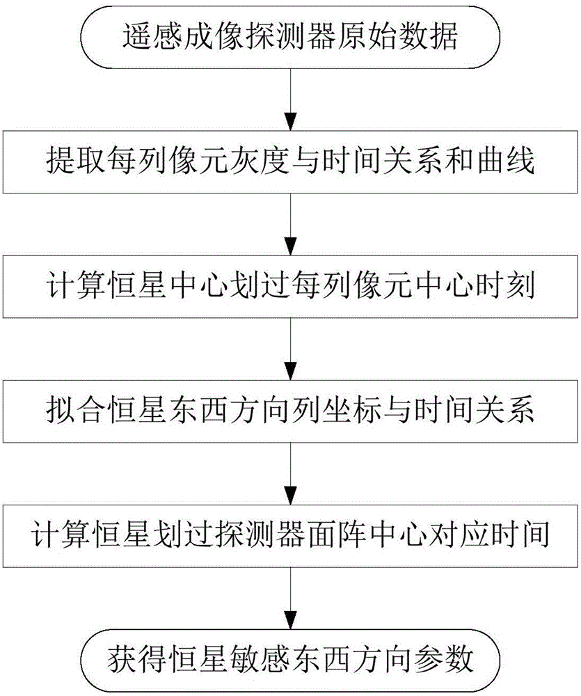
[0022] The present invention will be described in detail below in conjunction with specific embodiments. The following examples will help those skilled in the art to further understand the present invention, but do not limit the present invention in any form. It should be noted that those skilled in the art can make several changes and improvements without departing from the concept of the present invention. These all belong to the protection scope of the present invention.

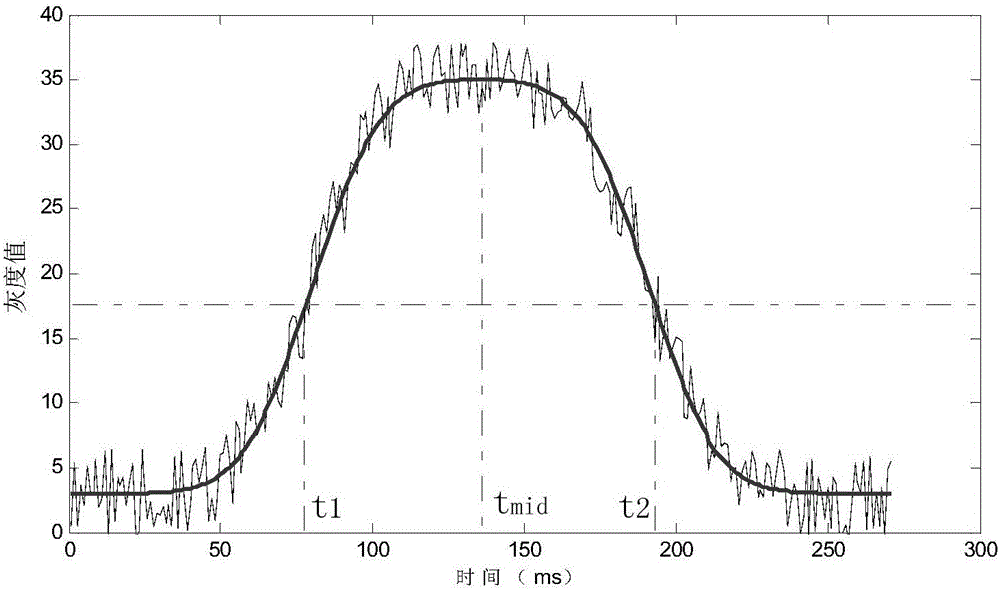
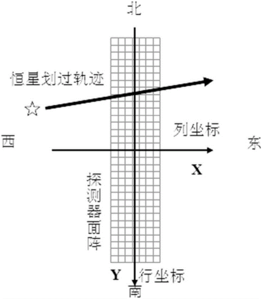
[0023] The height of the geostationary satellite is about 35786km, the direction of the satellite is the same as the direction of the earth's rotation, and the orbit is close to the plane of the earth's equator. From the perspective of the satellite looking at the earth, the column coordinates of the detector pixel of the space-borne remote sensing instrument correspond to the east-west direction, and the row coordinates correspond to the north-south direction. image 3 shown. When the effective image ...


PUM


Abstract

The invention provides an extracting method for fixed star sensitive east and west parameters of stationary satellite imaging navigation and registration. The extracting method comprises the following steps of obtaining a changing curve of a total gray value of pixels of each line along with time; obtaining a moment that a fixed star image center crosses a center line of the pixels of the line; fitting a motion law of the fixed star image center in east and west line coordinates of a satellite remote sensing detector array; obtaining a moment that the fixed star image center crosses a center line of the east-west direction of the satellite remote sensing detector array. According to the extracting method provided by the invention, high-frequency error of star positions caused by factors such as optical imaging of the detector, circuit noises, high-frequency wobble of a satellite and the like can be eliminated by multiframe data information fusion processing and curve fitting, thereby improving the identification accuracy of fixed star position parameters. The extracting method can be used for stationary satellite imaging navigation and registration, and has important significance for improving on-orbit thermal deformation precision of a remote sensing imaging system and the imaging navigation and registration processing property by acquiring parameters such accurate time and the like that the fixed star crosses the center of the detector array.

Description

technical field [0001] The invention relates to the overall technology of space vehicles and the field of satellite digital signal and image processing, in particular to a method for extracting parameters of stationary satellite imaging navigation and registration star sensitive objects. Background technique [0002] With the improvement of the application technology of remote sensing satellites, it is usually required that the images of the ground imaged by high-precision geostationary satellites be precisely positioned and registered to the nominal grid of the earth. However, satellite platforms and remote sensing instruments are affected by factors such as space mechanical environment and thermal environment changes. Satellites will have orbital drift and attitude pointing deviations, and instruments will produce geometric deformation, which will affect the positioning and registration accuracy of remote sensing images. The "satellite imaging navigation and registration" ...

Claims


Application Information

Patent Timeline
Patent Type & Authority Applications(China)
IPC IPC(8): G01C21/02
CPCG01C21/025
Inventor 吕旺王田野董瑶海信思博沈毅力
Owner SHANGHAI SATELLITE ENG INST
Why Eureka
Try Eureka