Wide-area collaborative precision remote sensing platform and remote sensing method thereof

A remote sensing and precise technology, applied to radio transmission systems, measuring devices, electrical components, etc., can solve problems such as wide-area, collaborative, precise remote sensing, limited working area, and insufficient maneuverability at the same time, so as to improve fault tolerance and The reliability of the system, the expansion of the scope of monitoring, and the effect of dispersing risks

Active Publication Date: 2016-08-31
BEIHANG UNIV
View PDF3 Cites 5 Cited by
  • Summary
  • Abstract
  • Description
  • Claims
  • Application Information

AI Technical Summary

Problems solved by technology

Existing technologies, such as the limited working area of ​​the UAV remote sensing platform; the insufficient maneuverability of a single near-space floating air balloon platform; the poor real-time performance of satellite remote sensing, all have inherent shortcomings of the platform
The existing patent "A Near Space Meteorological Platform" with application number 201510312110.6 is only a platform for measuring environmental meteorological information, which cannot achieve long-term airborne measurement, and one operation experiment cannot achieve accurate measurement of multiple local areas. , the existing remote sensing platform cannot simultaneously realize the mission requirements of wide-area, collaborative and precise remote sensing

Method used


Image

  • Wide-area collaborative precision remote sensing platform and remote sensing method thereof
  • Wide-area collaborative precision remote sensing platform and remote sensing method thereof
  • Wide-area collaborative precision remote sensing platform and remote sensing method thereof

Examples


Embodiment Construction

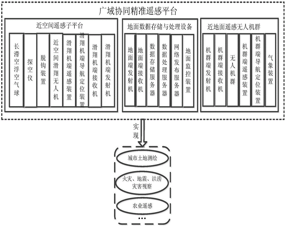
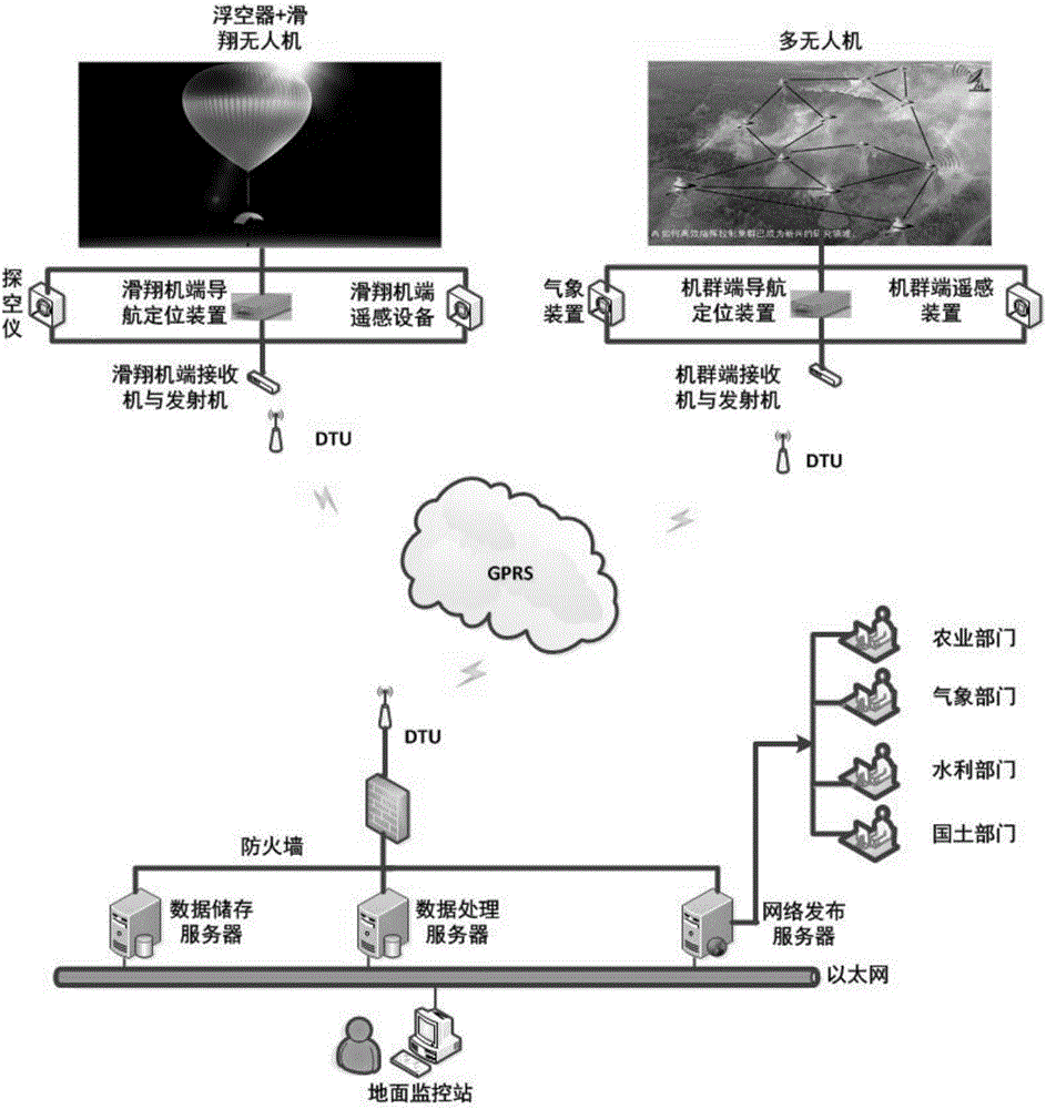
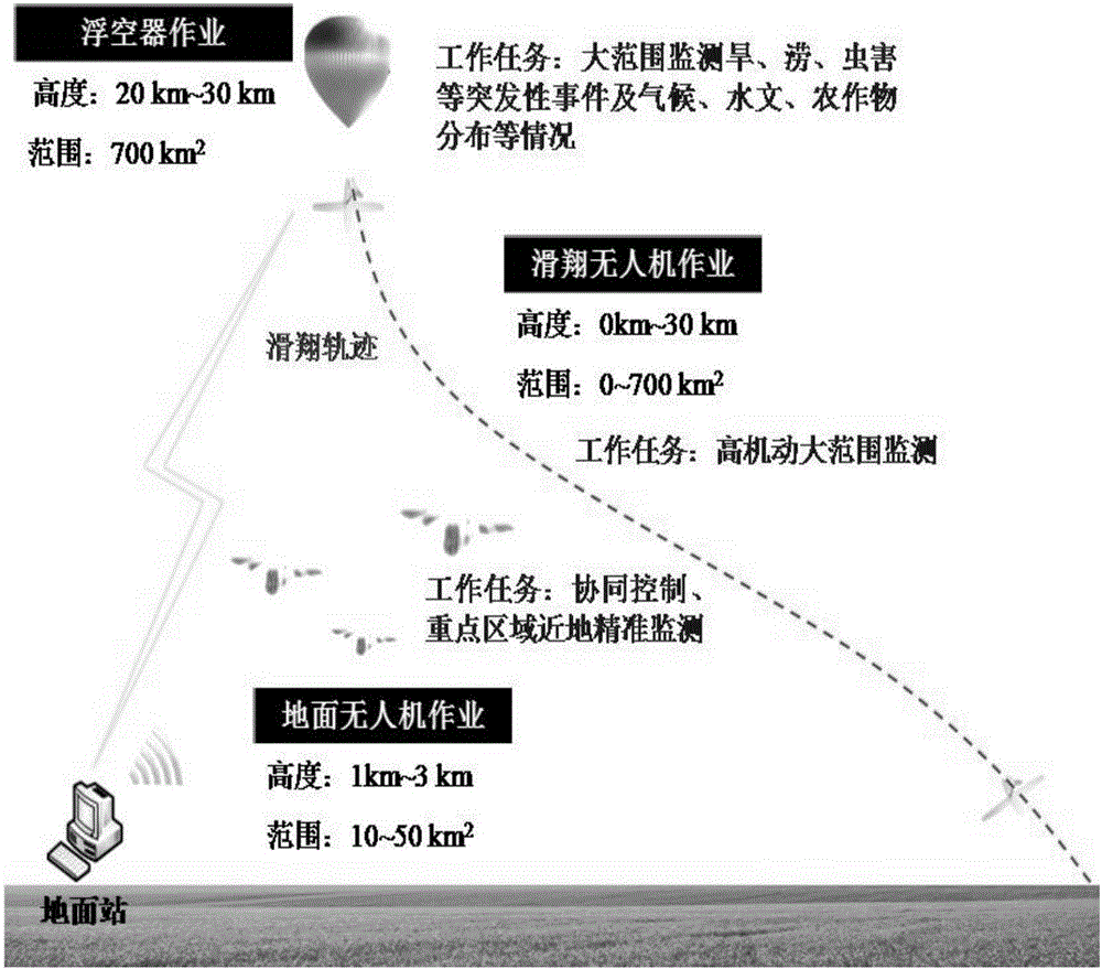
[0015] like figure 1 As shown, the wide-area collaborative precise remote sensing platform of the present invention includes a near-space remote sensing sub-platform, ground data storage and processing equipment, and a near-ground remote sensing drone group. The long stagnation aerostat is illustrated with the long stagnation air balloon as an example. The whole scheme is composed of the near-space remote sensing sub-platform, ground data storage and processing equipment, and near-ground remote sensing UAV group; the near-space remote sensing sub-platform consists of the long stagnation float The airsonde carried by the balloon is connected to the gliding UAV through the decoupling device and enters the sky at an altitude of 20-30 kilometers. The data storage and processing equipment realizes the storage, processing, and network release of big data of remote sensing, sports, and meteorological information; the near-ground remote sensing UAV group carries different remote sensi...


PUM


Abstract

The invention relates to a wide-area collaborative precision remote sensing platform and a remote sensing method thereof. The wide-area collaborative precision remote sensing platform comprises a near-space remote sensing sub platform, ground data storing and processing equipment, and a near-ground remote sensing unmanned aerial vehicle (UAV) group. According to the near-space remote sensing sub platform, a long-aloft aerostat carrying a sonde is connected with a gliding UAV through an unhooking device to lift off to a height of 20-30km. The near-space gliding UAV realizes large-scope and long-aloft positioning and remote sensing through a remote sensing and navigation positioning device carried thereby. The ground data storing and processing equipment realizes storing, processing and web releasing of remote sensing, motion and weather information big data. The near-ground remote sensing UAV group carries different remote sensing, navigation positioning and meteorological devices to receive control instructions issued by a ground monitoring station and collaboratively complete remote sensing, navigation positioning and other tasks at a height of 3km above the ground, so as to realize precision collaborative remote sensing. The remote sensing, motion and weather information big data provided by the platform can be offered to the agricultural, meteorological, water conservancy and other departments to better serve the national economy and the people's livelihood.

Description

technical field [0001] The invention is a near-space and near-ground collaborative remote sensing platform and method, which can be widely used in related fields of large-scale observation of the earth, and realize wide-area, multi-precision, and cooperative accurate remote sensing detection of the earth. Background technique [0002] The vast urban areas of our country are repeatedly threatened by sudden disasters such as drought and flood disasters, fires and earthquakes in populated areas, lack of effective monitoring and forecasting methods, and bring huge losses to the national economy; my country suffers from severe air pollution, Smog reduces the visibility of the atmosphere, weakens the photosynthesis of sunlight on crops, and can lead to a reduction in food production; my country's landforms are complex, the area of ​​cultivated land is limited, and the protection of cultivated land and the types of crops lack coordination and supervision; certain industrial and agric...

Claims


Application Information

Patent Timeline
Patent Type & Authority Applications(China)
IPC IPC(8): H04B7/185G01W1/02
CPCG01W1/02H04B7/18504H04B7/18523H04B7/18563
Inventor 郭雷吴克坚张霄李孟桃
Owner BEIHANG UNIV
Why Eureka
Try Eureka