Brightness temperature prediction method and system for MODIS forest fire detection

A prediction method and technology of brightness temperature, which is applied in the field of remote sensing information monitoring fire, can solve problems such as insufficient precision, ignoring the spatial distance attributes between background pixels and central pixels, etc. The effect of improving prediction accuracy

Active Publication Date: 2020-11-24
BEIJING NORMAL UNIVERSITY
View PDF6 Cites 0 Cited by
  • Summary
  • Abstract
  • Description
  • Claims
  • Application Information

AI Technical Summary

Problems solved by technology

[0004] To sum up, the brightness temperature prediction model currently used in fire detection takes into account the time attribute of the brightness temperature of the center pixel, the spatial relationship between the brightness temperature of the background pixel and the center pixel, and the time attribute, but ignores the background The spatial distance attribute between the pixel and the central pixel, the accuracy is not high enough

Method used


Image

  • Brightness temperature prediction method and system for MODIS forest fire detection
  • Brightness temperature prediction method and system for MODIS forest fire detection
  • Brightness temperature prediction method and system for MODIS forest fire detection

Examples


Embodiment 1

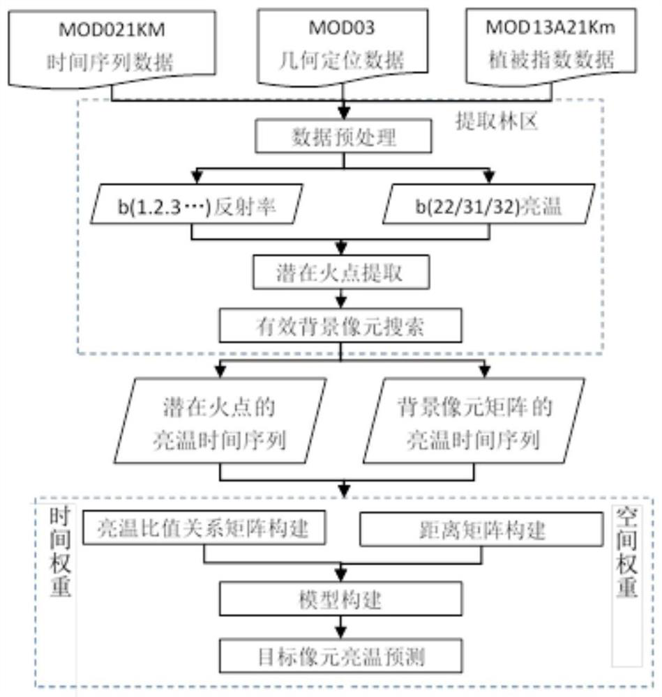
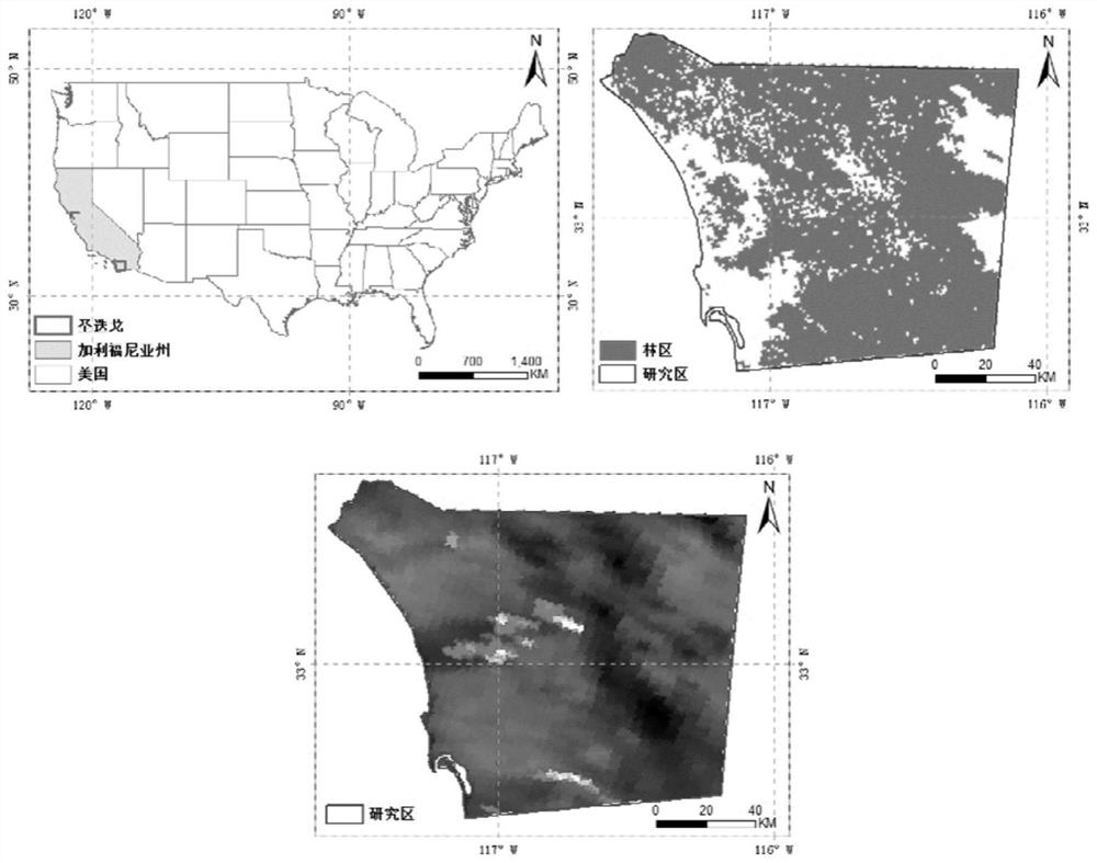
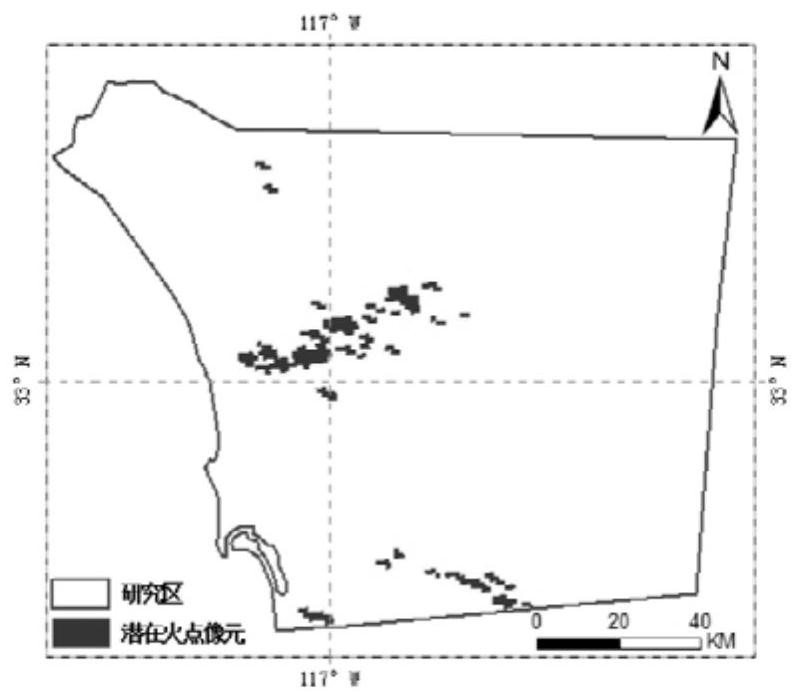
[0102] Taking San Diego in the southern California of the United States as the research area, based on the temporal and spatial attributes of its remote sensing data, a spatial context method based on temporal weight (TM, Temporal Model) is used to construct a brightness temperature prediction based on spatiotemporal weight for fire point detection. Model (STM, Spatio-Temporal Model), and by comparing two brightness temperature prediction models of TM and spatial context (CM, Contex Model), the advantages of the present invention are illustrated.

[0103] 1 Overview of the study area and data processing

[0104] San Diego (San Diego) in southern California is a forest fire-prone area. According to the forest fire data recorded by EM-DAT (International Disaster Database) from 1900 to 2016: there were 78 forest fires in the United States, of which 41 occurred in California and 8 in San Diego, causing a total of more than 17 deaths , the affected area is 650,000 km2, and the eco...


PUM


Abstract

The invention relates to an MODIS-oriented brightness temperature prediction method and system for forest fire detection. The method includes the steps of receiving MODIS data of setting areas and setting time; processing the MODIS data; calculating brightness and temperature. According to the method, prediction precision of brightness and temperature of picture element can be effectively improved, the discrimination precision of relative fire points can be further improved, and the correction judgement rate of the fire points is increased.

Description

technical field [0001] The invention relates to the field of fire monitoring using remote sensing information, in particular to a brightness temperature prediction method and system for MODIS forest fire detection. Background technique [0002] Forest fires are sudden and destructive, and can easily cause huge impacts on the environment, ecological health, and personal property. Hundreds of thousands of forest fire disasters occur every year in the world, and the affected area reaches millions of hectares, accounting for about 0.1% of the total forest area. Satellite remote sensing technology can provide large-scale, continuous, and low-cost information, and is widely used in forest fire monitoring. Fast and accurate acquisition of spatial and temporal information of forest fire information can effectively reduce the impact of fire. Moderate resolution imaging spectroradiometer (MODIS: Moderate resolution imaging spectroradiometer) has high radiation resolution, medium spat...

Claims


Application Information

Patent Timeline
Patent Type & Authority Patents(China)
IPC IPC(8): G01J5/00
Inventor 宫阿都李静陈艳玲王静梅曾婷婷
Owner BEIJING NORMAL UNIVERSITY
Why Eureka
Try Eureka