Large-scale three-dimensional forest drawing method

A forest and three-dimensional technology, applied in the field of digital earth visualization, can solve the problems of forest realism reduction, difficulty in rapid large-scale drawing, and difficult realization of forest dynamic display

CN111354081APending Publication Date: 2020-06-30GEOVIS CO LTD
0 Cites 1 Cited by

Patent Information

Authority / Receiving Office
CN · China
Current Assignee / Owner
Publication Date
2020-06-30

Smart Images

  • Figure 1
    Figure 1
  • Figure 2
    Figure 2
  • Figure 3
    Figure 3
Patent Text Reader

Abstract

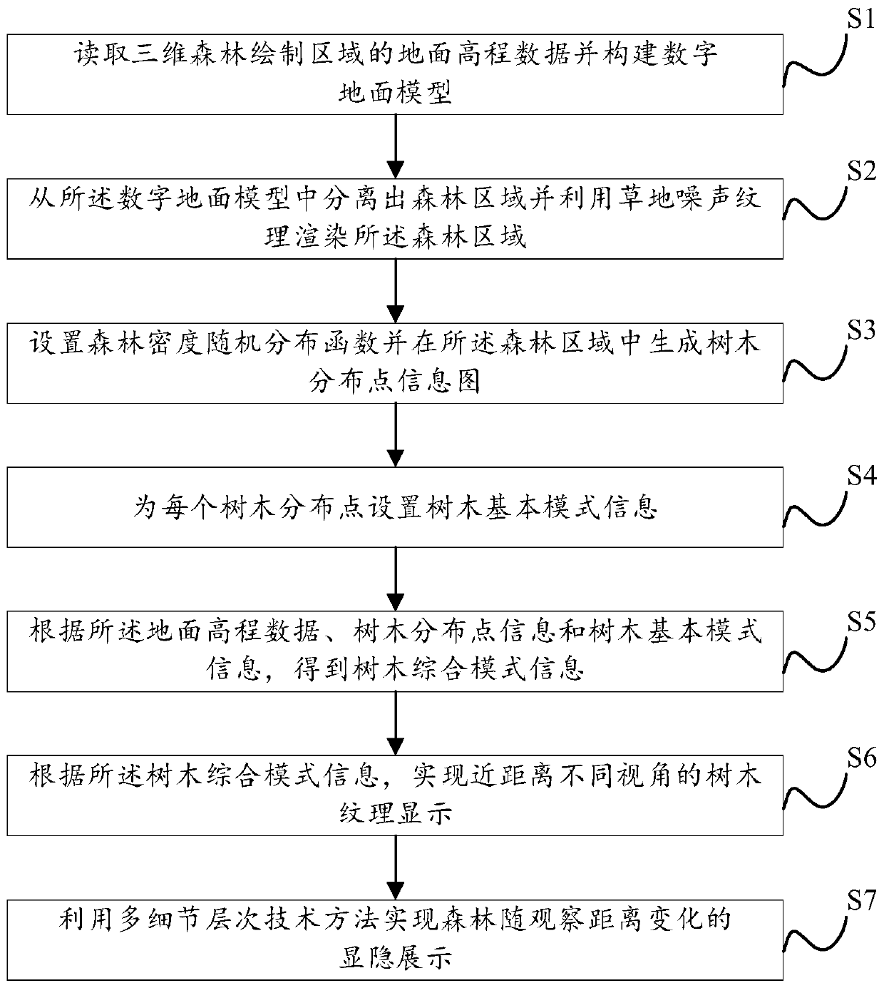
The invention provides a large-scale three-dimensional forest drawing method. The large-scale three-dimensional forest drawing method comprises the steps of S1, reading ground elevation data of a three-dimensional forest drawing area and constructing a digital ground model; s2, separating a forest region from the digital ground model and rendering the forest region by utilizing grassland noise texture; s3, setting a forest density random distribution function and generating a tree distribution point information graph in the forest area; s4, setting tree basic mode information for each tree distribution point; s5, obtaining tree comprehensive mode information according to the ground elevation data, the tree distribution point information and the tree basic mode information; s6, according tothe tree comprehensive mode information, achieving close-range tree texture display at different visual angles; and S7, achieving explicit and implicit display of the forest along with the change ofthe observation distance by utilizing a multi-detail-level technical method. According to the method, the large-scale three-dimensional forest can be rapidly drawn, and the drawn three-dimensional forest is high in sense of reality.
Need to check novelty before this filing date? Find Prior Art

Description

technical field

[0001] The invention relates to digital earth visualization technology, in particular to a large-scale three-dimensional forest rendering method. Background technique

[0002] Digital Earth is a technology that uses massive earth information to describe the earth with multi-resolution, multi-scale, multi-time and space, and multi-type, and uses it as a tool to support and improve human activities and quality of life. It is used in civilian and military fields. have a very wide range of applications. Digital Earth needs to be constructed and rendered with 3D images to play its role, and the biggest challenge in 3D image construction and rendering is the generation and real-time rendering of large-scale scenes. In particular, the morphological structure of the forest area is complex, and it is difficult to render with a unified model modeling method.

[0003] According to different modeling methods, the construction technology of 3D forest can be divided into...

Examples

Embodiment Construction

[0030] In order to understand the above-mentioned purpose, features and advantages of the present invention more clearly, the present invention will be further described in detail below in conjunction with the accompanying drawings and specific embodiments. It should be noted that, in the case of no conflict, the embodiments of the present application and the features in the embodiments can be combined with each other.

[0031] In the following description, many specific details are set forth in order to fully understand the present invention. However, the present invention can also be implemented in other ways different from those described here. Therefore, the protection scope of the present invention is not limited by the specific details disclosed below. EXAMPLE LIMITATIONS.

[0032] refer to figure 1 , which shows the large-scale three-dimensional forest rendering method of the present invention, comprising the following steps:

[0033] S1: Read the ground elevation dat...