Air temperature estimation method based on satellite data fusion

A temperature and data technology, applied in the field of satellite meteorology, can solve the problem that optical satellite sensors are difficult to obtain temperature data, the temperature does not have a large range of continuity, and the space-time contradiction between geostationary satellites and polar orbiting satellites is difficult to obtain high time and high spatial resolution temperature Problems such as data difficulties, to achieve the effect of improving accuracy and stability, improving application, high accuracy and stability

Active Publication Date: 2021-07-13
CHENGDU UNIV OF INFORMATION TECH
View PDF7 Cites 1 Cited by
  • Summary
  • Abstract
  • Description
  • Claims
  • Application Information

AI Technical Summary

Problems solved by technology

[0003] However, it is difficult to obtain temperature data with high temporal and high spatial resolution by optical satellite sensors on a single platform, which limits the promotion and application of remote sensing temperature data.
Obtaining temperature throu

Method used


Image

  • Air temperature estimation method based on satellite data fusion
  • Air temperature estimation method based on satellite data fusion
  • Air temperature estimation method based on satellite data fusion

Examples


Embodiment

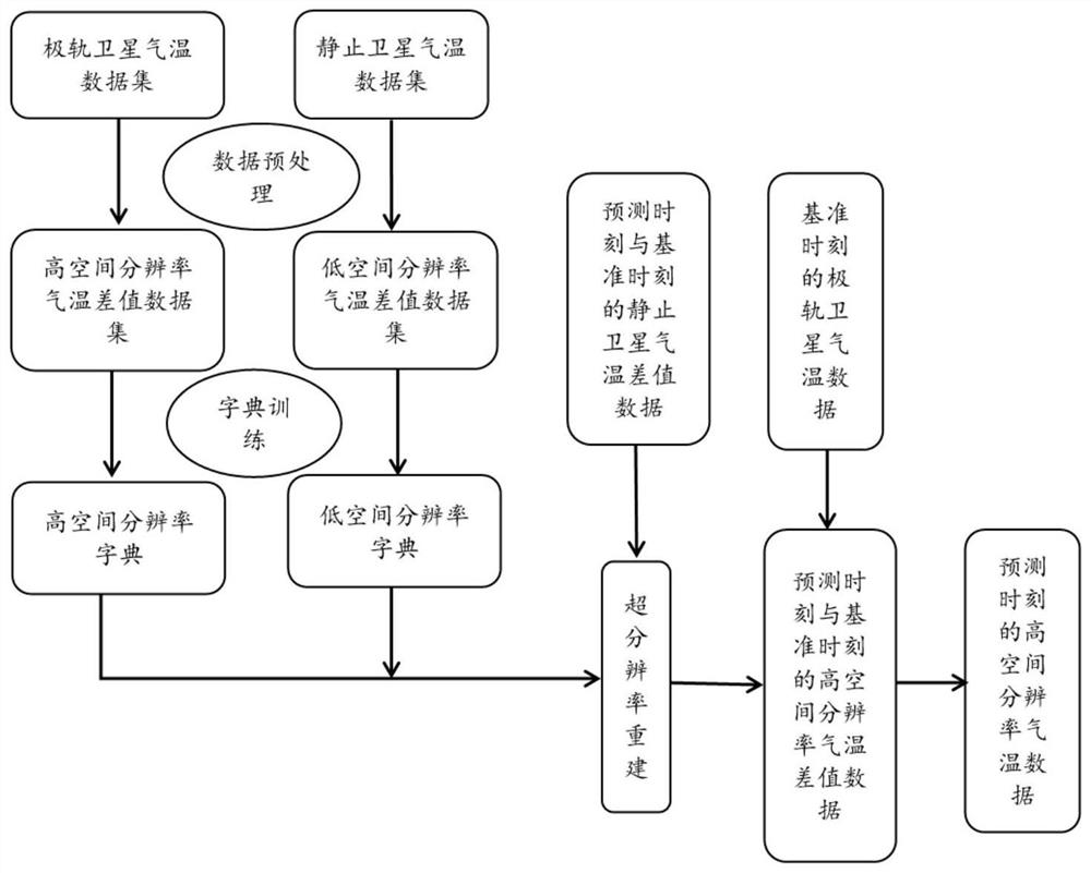
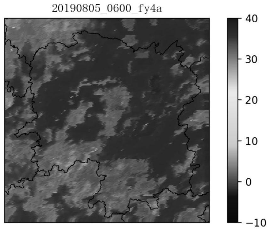
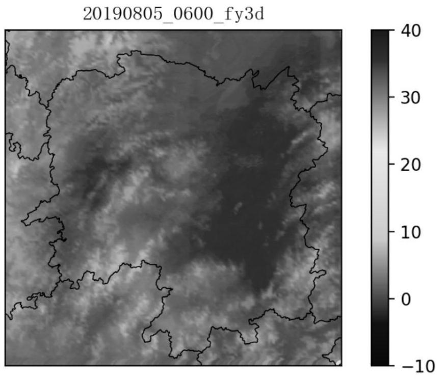
[0066] Using the products of FY3D (250m, twice a day) from the polar-orbiting meteorological satellite FY3D with high spatial resolution and FY4A from the geostationary meteorological satellite FY4A with low spatial resolution (4000m, once an hour), the temperature data in Hunan were obtained. Using the method in this paper to fuse multi-source satellite data, a new satellite temperature product with high time (once per hour) and high spatial resolution (250m) is produced.

[0067] Algorithm effect:

[0068] The temperature data of FY3D and FY4A at the reference time of 06:00 on August 5, 2019 and the temperature data of FY4A at the forecast time of 07:00 on August 5, 2019 are fused to obtain the high spatial resolution satellite temperature product at the forecast time.

[0069] figure 2 and image 3 They are the geostationary satellite temperature map and the polar-orbiting satellite temperature map at the reference time respectively. Comparing these two pictures, it can ...


PUM


Abstract

The invention provides an air temperature estimation method based on satellite data fusion. The air temperature estimation method comprises the following steps: 1, preprocessing acquired geostationary satellite air temperature data and polar orbit satellite air temperature data; 2, establishing an air temperature difference dictionary by using the preprocessed geostationary satellite air temperature data and polar orbit satellite air temperature data; 3, performing super-resolution reconstruction on difference data of the geostationary satellite air temperature data at the reference moment and the geostationary satellite air temperature data at the prediction moment by using the air temperature difference dictionary to obtain reconstructed air temperature difference data with high spatial resolution; 4, adding the polar orbit satellite air temperature data at the reference moment and the obtained air temperature difference value data with the high spatial resolution to obtain a high spatial resolution satellite air temperature product at the prediction moment; and 5, according to the time resolution of the geostationary satellite air temperature data, continuously generating corresponding high-spatial-resolution satellite air temperature data with high time resolution. The data obtained by the method is higher in accuracy and stability.

Description

technical field [0001] The invention relates to the technical field of satellite meteorology, in particular to a temperature estimation method for high temporal and spatial resolution satellite data fusion of static and polar-orbiting meteorological satellite data fusion. Background technique [0002] At present, temperature data are mainly obtained through stations, and interpolation methods are often used for estimation of large-scale temperature data. Remote sensing has the characteristics of macroscopic, dynamic, convenient, economical, and periodic, and can provide timely information on a large scale, which is unmatched by stations. The superiority of the method provides a way to obtain large-scale temperature data. [0003] However, it is difficult to obtain temperature data with high temporal and high spatial resolution by optical satellite sensors on a single platform, which limits the promotion and application of remote sensing temperature data. Obtaining temperatu...

Claims


Application Information

Patent Timeline
IPC IPC(8): G06K9/62
CPCG06F18/251Y02A90/10
Inventor 邓小波陈瑶瑶廖玉芳韩沁哲黄启宏刘海磊唐顺仙
Owner CHENGDU UNIV OF INFORMATION TECH
Why Eureka
Try Eureka