Contour line drawing method based on ArcGIS and AutoCAD

A contour and elevation technology, applied in the field of high line drawing, can solve the problems of inconvenient drawing and achieve high accuracy

Pending Publication Date: 2022-06-07
SHANGHAI INVESTIGATION DESIGN & RES INST
View PDF0 Cites 0 Cited by
  • Summary
  • Abstract
  • Description
  • Claims
  • Application Information

AI Technical Summary

Problems solved by technology

And when there is no topographic map related to geological survey, it is inconvenient to draw directly with AutoCAD software

Method used


Image

  • Contour line drawing method based on ArcGIS and AutoCAD

Examples


Embodiment Construction

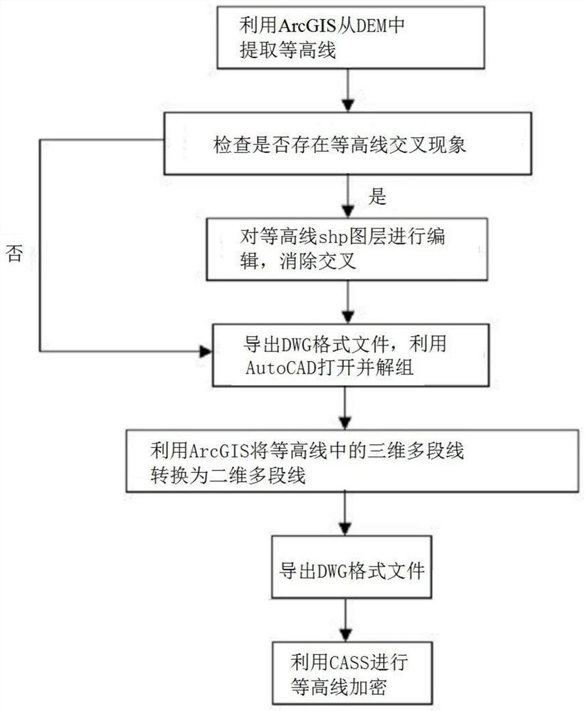
[0020] The embodiments of the present invention are described below by specific embodiments, and those skilled in the art can easily understand other advantages and effects of the present invention from the contents disclosed in this specification.

[0021] It should be noted that the structures, proportions, sizes, etc. drawn in the accompanying drawings in this specification are only used to cooperate with the contents disclosed in the specification for the understanding and reading of those who are familiar with the technology, and are not intended to limit the conditions for the implementation of the present invention. Therefore, without technical substantive significance, any modification of structure, change of proportional relationship or adjustment of size should still fall within the scope disclosed in the present invention without affecting the effect that the present invention can produce and the purpose that can be achieved. within the scope of technical content. A...


PUM


Abstract

The invention relates to a contour line drawing method based on ArcGIS and AutoCAD, and the method comprises the following steps: S1, downloading required digital elevation model data matched with a real terrain, and carrying out contour line extraction through opening in ArcGIS to obtain a contour line shp layer; s2, adding entity attributes in the CAD to the contour line shp layer, and assigning a 'Contour' attribute in the contour line shp layer to an Element in the CAD attribute in an attribute table; checking whether a contour line crossing phenomenon exists in the contour line shp layer or not; s3, exporting by utilizing an ArcGIS contour line shp layer to obtain a dwg format file; s4, opening the dwg-format file by using AutoCAD, and ungrouping the contour lines to obtain a dwg-format file with the contour lines of the three-dimensional polyline and the two-dimensional polyline at the same time; s5, opening the dwg format file by utilizing ArcGIS, and converting a three-dimensional polyline in the contour line into a two-dimensional polyline to obtain a contour line shp layer; and S6, exporting the contour line shp layer into a dwg format file again by utilizing ArcGIS, wherein the dwg format file has a contour line layer containing elevation information.

Description

technical field [0001] The invention relates to the field of engineering technology, in particular to a watershed contour drawing method based on ArcGIS and AutoCAD. Background technique [0002] AutoCAD software can be used for two-dimensional drawing, detailed drawing, design documentation and basic three-dimensional design, and has now become a widely popular drawing tool in the world. AutoCAD's dwg file format expresses spatial objects through points, lines, surfaces, annotations and symbols, and visualizes spatial entity elements through colors, layers, and annotations. In practical engineering applications, AutoCAD software is usually used to draw floor plans, section drawings, etc., so AutoCAD software is also commonly used to draw contour lines. When drawing contour lines, preliminary topographic survey is often required as the topographic basis for construction drawings. When there is no topographic map related to the geological survey, it is inconvenient to draw ...

Claims


Application Information

Patent Timeline
Patent Type & Authority Applications(China)
IPC IPC(8): G06T11/20G06T17/05
CPCG06T11/203G06T17/05
Inventor 刘家琳
Owner SHANGHAI INVESTIGATION DESIGN & RES INST
Why Eureka
Try Eureka