Determining positions in a wireless radio system

a wireless radio and position determination technology, applied in the direction of measuring devices, instruments, electrical equipment, etc., can solve the problems of not being detected, not being able to access all places with a motor vehicle, and high cost of war-driving, so as to improve quality and accuracy.

Inactive Publication Date: 2012-06-07
RPX CORP
View PDF3 Cites 23 Cited by
  • Summary
  • Abstract
  • Description
  • Claims
  • Application Information

AI Technical Summary

Benefits of technology

[0016]It is a second object of the invention to provide positioning s...

Problems solved by technology

First of all, it is not possible to access all places with a motor vehicle, so some hotspots may not be detected by war-driving.
Furthermore, war-driving is expensive.
However, frequently the positioning results are not so accurate.
This limited accuracy is caused amongst others by the following error sources:The signal power emitted by a hotspot is unknown and may be different for each hardware type.
The hotspot does not send any information on the emitted signal power on its broadcasting message and therefore, if the received power signal is low, it is not possible to know if is due to a low signal power emitted or just due to a long distance between the measuring device and the hotspot.Wifi signals go through walls, roofs, etc. and therefore, again, if a low power signal is received, i...

Method used


Image

  • Determining positions in a wireless radio system
  • Determining positions in a wireless radio system
  • Determining positions in a wireless radio system

Examples


first embodiment

of the Invention

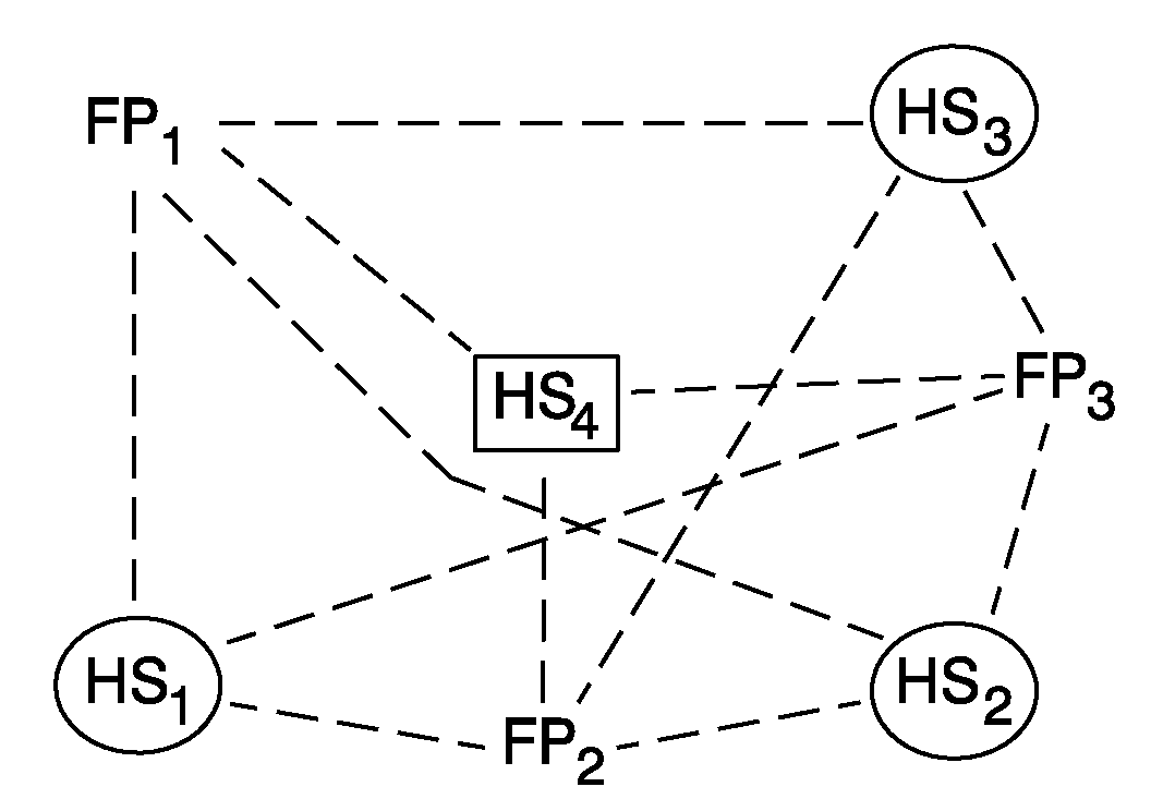
[0052]Referring now to FIGS. 1A-1C, a first embodiment of the present invention will be described.

[0053]A radio-map is a set of hotspots containing their positions and some unique parameters of them. At any point of time, the radio-map can have 2 categories of hotspots:

[0054]1) Those calculated by using fingerprints with geo-positions associated (from war-driving for instance).

[0055]2) Those related to fingerprints without any geo-position assigned (orphan hotspots).

[0056]Radio-Map Expansion Algorithm

[0057]The first embodiment of the present invention relates to a method for expanding the radio-map by estimating and including the position of such orphan hotspots.

[0058]The method consists of the following steps:[0059]For every orphan hotspot, select all the fingerprints that have seen the orphan hotspot. This step is schematically shown in FIG. 1A. The hotspot HS4 of which the position is unknown and to be estimated (schematically indicated in the figure by the rectan...

second embodiment

of the Invention

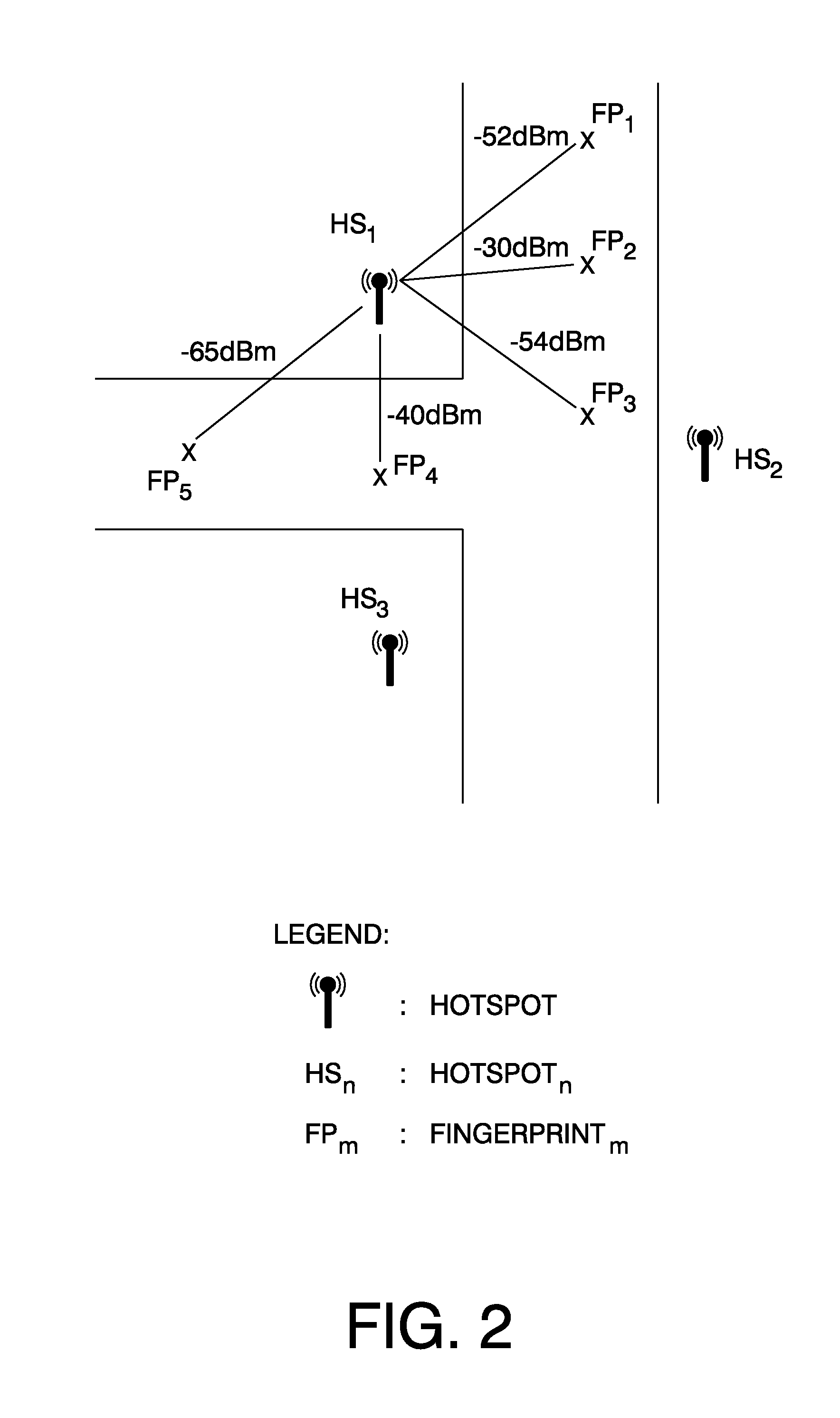
[0071]Referring now to FIGS. 2-4, a second embodiment of the present invention will be described.

[0072]The second embodiment relates to a WiFi positioning method with a higher accuracy than known WiFi positioning methods. It can be used for estimating the position of a hotspot that is “seen” on a number of fingerprints taken at different measurement locations with a known geo-position. An example thereof is schematically shown in FIG. 2. Here hotspot HS1 is seen on fingerprints FP1, FP2, FP3, FP4 and FP5 with a signal power of −52 dBm, −30 dBm,−54 dBm, −40 dBm and −65 dBm, respectively. Although, in this example only 5 fingerprints are shown, in practical situations this number may be usually much higher. The signal of the hotspot HS1 seen on each of the fingerprints FP1, FP2, FP3, FP4, FP5 corresponds to one measurement (so in the example of FIG. 2 there are five measurements).

[0073]It can also be used for estimating the position of a wireless enabled (end-user) dev...

third embodiment

of the Invention

[0099]Referring now to FIG. 5, a third embodiment of the present invention will be described.

[0100]The third embodiment relates to a trilateration process. As discussed herein above, trilateration is a method of determining the relative positions of objects using the geometry of triangles in a similar fashion as triangulation. Unlike triangulation, which uses angle measurements (together with at least one known distance) to calculate the subject's location, trilateration uses the known locations of two or more reference points, and the measured distance between the subject and each reference point. To accurately and uniquely determine the relative location of a point on a 2D plane using trilateration alone, generally at least 3 reference points are needed.

[0101]The trilateration in FIG. 5 is shown for the case that the position of a wireless enabled device is determined based on three detected hotspots HS1, HS2, HS3 in a fingerprint FP1. However, the trilateration ac...


PUM


Abstract

A method is described for expanding the radio-map of a WiFi system. A hotspot (HS4) of which the position is unknown and to be estimated is “seen” in a number of fingerprints (FP1, FP2, FP3), each taken at a different position. Several hotspots with a known position (HS1, HS2 and HS3) are also “seen” in the fingerprints (FP1, FP2, FP3). The geo-positions of the measurement locations, where the fingerprints (FP1, FP2, FP3) were taken, are estimated based on the signals from the hotspots (HS1, HS2, HS3) with known geo-position seen in the fingerprints and the known geo-positions of those hotspots. The position of the hotspot (HS4) is determined based on the signals from that hotspot (HS4) seen in the fingerprints and the geo-positions of the measurement locations where the fingerprints were taken, estimated in the previous step.

Description

BACKGROUND OF THE INVENTION[0001]1. Technical field[0002]The present invention relates to methods and systems for determining the positions of access points and end-user devices of a wireless radio system. More particularly the present invention relates to methods and systems for determining the positions of access points and end-user devices of WiFi systems, i.e. systems working according to the IEEE 802.11 standard.[0003]2. Description of related art[0004]The availability of Wifi systems has grown considerably over the recent years. Some companies offer tools for performing a worldwide hotspot (access point) search. Based on a street address provided by the user, the tools retrieve from a database of hotspots the nearest hotspot(s) for the user. This database of hotspots is called a radio-map. The user is provided with the name and location of the hotspots, as well as the access type (commercial, free of charge). Radio-maps may be used either online (with an available Internet con...

Claims


Application Information

Patent Timeline
IPC IPC(8): H04W24/00G01S5/02
CPCG01S5/0252H04W64/003G01S5/14G01S5/02521
Inventor DE CASTRO RIESCO, MARCOSGALLEGO, ANGELGALLER, JURGEN
Owner RPX CORP
Why Eureka
Try Eureka