Energy carbon emission remote sensing estimation method based on night light images

A nighttime lighting image and carbon emission technology, applied in the field of inversion, can solve the problems of large differences in urban development levels and industrial structure types, and achieve similar shapes with high accuracy, unique spatio-temporal continuity, and make up for incomplete statistical data. Effect

Active Publication Date: 2015-12-30
GUANGZHOU INST OF GEOGRAPHY GUANGDONG ACAD OF SCI +1
View PDF4 Cites 17 Cited by
  • Summary
  • Abstract
  • Description
  • Claims
  • Application Information

AI Technical Summary

Problems solved by technology

[0007] A few scholars at home and abroad have applied DMSP/OLS night light data to the estimation of energy and carbon emissions. However, the current inversion model still has major shortcomings.
my country's cities have great differences in development levels and industrial structure types. There are also significant

Method used


Image

  • Energy carbon emission remote sensing estimation method based on night light images
  • Energy carbon emission remote sensing estimation method based on night light images
  • Energy carbon emission remote sensing estimation method based on night light images

Examples


Embodiment Construction

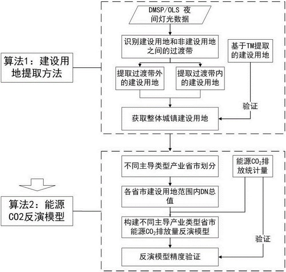
[0052] The content of the present invention will be described in further detail below in conjunction with the accompanying drawings and specific embodiments.

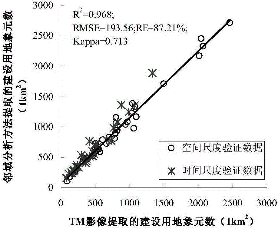
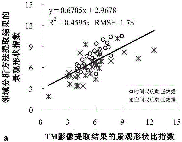
[0053] The present invention provides a remote sensing estimation method of energy carbon emissions based on DMSP / OLS night light images, which can obtain the energy carbon emissions of each region according to the total value of night light data by establishing a remote sensing inversion model of energy carbon emissions (i.e. energy CO 2 Emissions) analog quantity.

[0054] The present invention proposes two hypotheses: (1) The total value of night light data (SDN) within the scope of the construction land has a certain correlation with the energy carbon emissions (C) of the area, so as to find out the energy carbon emissions (C) of the area The quantitative relationship between the night light data total value (SDN) and night light data is one of the technical problems mainly solved by the present invention. (2) Ene...


PUM


Abstract

The invention provides an energy carbon emission remote sensing estimation method based on night light images. The method includes the following steps that first, urban construction land is extracted on the basis of the night light images; second, energy carbon emission is simulated on the basis of the night light images. The first step includes the steps that eleventh, a transition zone of the construction land and non-construction land is recognized; twelfth, the construction land beyond the transition zone is extracted; thirteenth, the construction land contained in the transition zone is extracted; fourteenth, all the construction land is obtained. The second step includes the steps that twenty-first, the total value of night light data within all the construction land of an area to be measured is extracted; twenty-second, multiple leading industry types are divided; twenty-third, energy carbon emission inversion models of different leading industry types are constructed. By building the energy carbon emission models, energy carbon emission of any region can be predicted according to the night light images and different leading industry types.

Description

technical field [0001] The invention relates to inversion technology, in particular to a method for remote sensing estimation of energy and carbon emissions based on night light images. Background technique [0002] Exploring the carbon emissions caused by human activities such as economic development and energy consumption has become a hot topic in domestic and foreign academic circles. According to statistics, since 2000, China's CO 2 The average annual growth rate of emissions is about 10%. In 2008, carbon emissions reached 8.325 billion tons, surpassing the United States to become the world's largest carbon emitter. Huge emissions and high growth rate have put China under enormous pressure to reduce emissions. Due to the great differences in the economic and social development and energy consumption structure of various regions in China, scientifically and accurately measuring and analyzing the temporal and spatial changes of carbon emissions in different regions and r...

Claims


Application Information

Patent Timeline
IPC IPC(8): G06K9/00G06K9/34
CPCG06V20/13G06V10/267
Inventor 苏泳娴陈修治李勇
Owner GUANGZHOU INST OF GEOGRAPHY GUANGDONG ACAD OF SCI
Why Eureka
Try Eureka