Geographic cloud data based spatial matching method

A matching method and cloud data technology, applied in the field of spatial matching, can solve problems such as large amount of calculation and failure of iterative process to converge

Inactive Publication Date: 2016-02-03
SUZHOU SHENGJING INFORMATION TECH CO LTD
View PDF2 Cites 8 Cited by
  • Summary
  • Abstract
  • Description
  • Claims
  • Application Information

AI Technical Summary

Problems solved by technology

However, it can be seen from the description of the algorithm that it has the disadvantages of a large amount of calculation and the iterative process may not be able to converge to the global optimal solution.

Method used


Image

  • Geographic cloud data based spatial matching method
  • Geographic cloud data based spatial matching method
  • Geographic cloud data based spatial matching method

Examples


Embodiment Construction

[0044] The technical solutions of the embodiments of the present invention will be clearly and completely described below in conjunction with the accompanying drawings of the present invention.

[0045] like figure 1 As shown, a kind of spatial matching method based on geographic cloud data disclosed by the present invention includes:

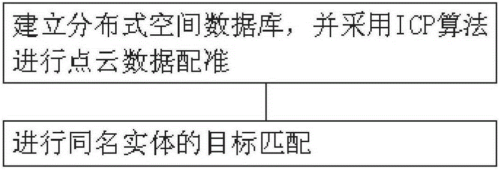
[0046] Step 1: Establish a distributed spatial database, and use the ICP algorithm for point cloud data registration.

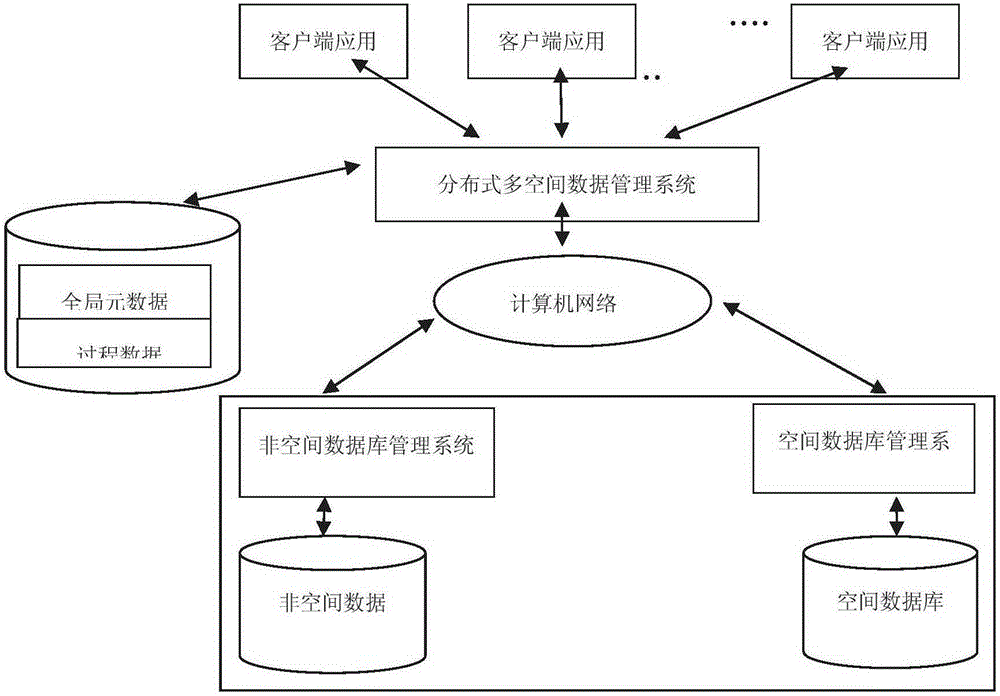
[0047] combine figure 1 and figure 2 As shown, the system structure of the distributed multi-spatial database established by the present invention adopts the Client / Serve structure, which is a completely independent management system participating in the spatial database, each of which manages its own database. The distributed multi-spatial database management system is a layer of software running on top of these independent spatial database management systems and non-spatial database management systems. It is responsible ...


PUM


Abstract

The invention discloses a geographic cloud data based spatial matching method. The method comprises: step 1, establishing a distributed spatial database, and performing point cloud data registration by adopting an ICP algorithm, wherein in the point cloud registration process, the adjustment is performed with a multi-point least square fitting method, and a transformation matrix is calculated; and step 2, performing target matching of entities same in name. According to the method, geographic information, spatial position information and attribute information can be quickly queried and called, and accurate matching of spatial data is realized by further applying a method for matching the entities same in name; and meanwhile, the least square fitting is also adopted, and the transformation matrix is calculated through a plurality of points in a three-dimensional space, so that the calculation method is simple, and the registration precision can be effectively improved.

Description

technical field [0001] The invention relates to a space matching technology, in particular to a space matching method based on geographic cloud data. Background technique [0002] With the advent of the information society, the ability of human beings to obtain spatial information has been significantly improved compared with the past. In the face of massive information, people's demand for information has undergone tremendous changes. Higher and higher. [0003] Traditional GIS (Geographic Information System, geographic information system) databases often exist alone, and the phenomenon of information islands is serious. Each department is different according to its own specific situation and application requirements, which leads to differences in structural data, data models, and data formats of GIS data. , the data is difficult to share. Although WebGIS (Network Geographic Information System) can also meet the sharing requirements of heterogeneous geospatial data at thi...

Claims


Application Information

Patent Timeline
Patent Type & Authority Applications(China)
IPC IPC(8): G06F17/30
CPCG06F16/29
Inventor 杨俊鲁雪松汪小东曾书昶钮立明陈建伟
Owner SUZHOU SHENGJING INFORMATION TECH CO LTD
Why Eureka
Try Eureka