Collaborative plotting spatial system of heterogeneous spatial information based on cloud computing technology

A collaborative plotting and spatial information technology, applied in the information field, can solve problems such as insufficient spatial knowledge information, restricting the development of social application of spatial information, and low service level, so as to overcome the difficulties of management and expansion and improve problem-solving ability, the effect of reducing the total cost

Inactive Publication Date: 2016-04-27
GUILIN UNIVERSITY OF TECHNOLOGY
View PDF4 Cites 9 Cited by
  • Summary
  • Abstract
  • Description
  • Claims
  • Application Information

AI Technical Summary

Problems solved by technology

[0004] However, my country's spatial knowledge information is not rich enough, and the service level remains at a low level, which has begun to restrict the development of social application of spatial information, which urgently requires my country to further increase spatial knowledge mining and service levels

Method used


Image

  • Collaborative plotting spatial system of heterogeneous spatial information based on cloud computing technology
  • Collaborative plotting spatial system of heterogeneous spatial information based on cloud computing technology
  • Collaborative plotting spatial system of heterogeneous spatial information based on cloud computing technology

Examples


Embodiment Construction

[0089] specific implementation

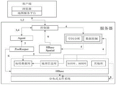
[0090] 1. User access to collaborative plotting system process

[0091] (1) The user implements operations such as login and registration through the HTTP protocol of the terminal browser, and sends it to the server in the form of a form, waiting for a response;

[0092] (2) An Ajax engine monitoring system is built on the server side to monitor the internal state changes of the server in real time. After the mapping file is configured, the server can use DWR technology to dynamically replace JavaScript with Java classes to realize interaction with the database, and complete saving and deletion during the plotting process and so on. Turn on event monitoring on the plotting map system to extract, identify and store data on user operations. For example, if the mouse is clicked on the map, the system will monitor the coordinate information of the click and respond to the user based on the current state;

[0093] (3) After extracting the operation ...


PUM


Abstract

The invention provides a collaborative plotting spatial knowledge system of heterogeneous spatial information based on cloud computing technology. The main purpose is to establish a collaborative plotting model of a heterogeneous space of a global map, and realize collaborative plotting with high concurrency and high online user number by means of the lateral expansion capability and the cloud computing. Therefore, dynamic collection of global information is realized, the island effect of the original spatial information is get rid of, the collaboration and communication ability of related spatial information users is reinforced, and the information is dug in depth, so that the spatial information service of the public and the departments improved from local and single contents to global spatial knowledge cloud services on a multi-subject level.

Description

technical field [0001] The invention relates to the field of information technology, in particular to a space system for collaborative plotting of heterogeneous space information based on cloud computing technology. Background technique [0002] With the rapid development of information technology and Internet technology, the amount of information that people come into contact with is increasing. The information service process is actually a process of disseminating information, exchanging information, and making information more valuable. The information collected and extracted during this activity does not need to refine and analyze the knowledge contained in it, so what people retrieve through various means is only the data itself, not necessarily knowledge. For example, when students search on the library's bibliographic retrieval system, the retrieval results only include the title and author of the book, and no knowledge can be seen. Although information services can...

Claims


Application Information

Patent Timeline
Patent Type & Authority Applications(China)
IPC IPC(8): H04L29/08G06F17/30
CPCH04L67/02H04L67/1097G06F16/182G06F16/29H04L67/52
Inventor 谢晓兰胡莘倪金生隆震黄顺柏何超杨顺兴欧其平
Owner GUILIN UNIVERSITY OF TECHNOLOGY
Why Eureka
Try Eureka