Three dimensional method of quickly determining reservoir bank collapse scale

A reservoir, three-dimensional technology, applied in the direction of surveying devices, instruments, surveying and navigation, etc., can solve problems such as not giving clear guidance and regulations, failing to meet engineering design requirements, and determining the scale of bank collapse, etc., to avoid The effect of increased engineering investment

Inactive Publication Date: 2017-10-24
CHINA HYDROELECTRIC ENGINEERING CONSULTING GROUP CHENGDU RESEARCH HYDROELECTRIC INVESTIGATION DESIGN AND INSTITUTE
View PDF6 Cites 1 Cited by
  • Summary
  • Abstract
  • Description
  • Claims
  • Application Information

AI Technical Summary

Problems solved by technology

[0002] With the development and expansion of water conservancy and hydropower projects, high dams and large reservoirs frequently appear in the mountainous areas of southwest my country. After the reservoirs are impounded, the rock (soil) on the bank slope is subjected to internal and external geological forces, and the bank collapses. It is difficult for geological engineers to accurately identify and express For the irregular geological bodies in the above two situations, the current traditional geotechnical engineering investigation methods and means mainly use profile measurement, combined with the engineering experience of geological engineers or general laws and principles to generalize the spatial distribution of geological bodies, but When the above-mentioned non-collapsible bank surface is distributed in important engineering parts, if its boundary involves important buildings, such as resettlement reconstruction buildings, etc., simple generalization treatment cannot meet the requirements of engineering design, and the current relevant regulations and specifications do not provide for the above-mentioned situation. To the best of the knowledge of the applicant, there is no three-dimensional method to quickly determine the scale of this type of bank collapse

Method used


Image

  • Three dimensional method of quickly determining reservoir bank collapse scale

Examples


Embodiment Construction

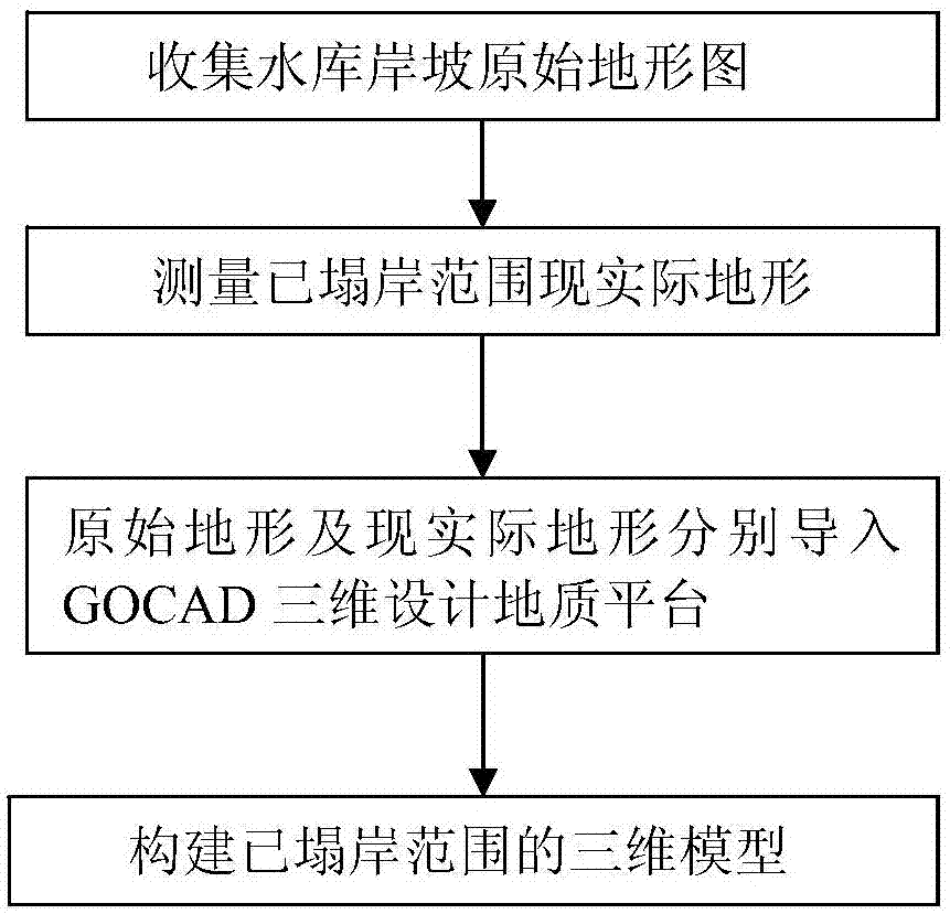
[0014] The embodiment provides a three-dimensional method for rapidly determining the scale of bank collapse of a reservoir, such as figure 1 shown, including the following steps:

[0015] A. Collect the original topographic map of the reservoir bank slope;

[0016] B. Use total station instruments and / or aerial photography and aerial surveys to conduct topographic surveys of the bank collapsed area of ​​the reservoir, obtain the actual topographic map of the bank collapsed area, and focus on measuring the topographical fluctuations within the bank collapsed area. ;

[0017] C. Import the original topographic map and the actual topographic map into the GOCAD 3D design geological platform to form the original topographic surface and the actual topographic surface respectively;

[0018] D. In the GOCAD three-dimensional design geological platform, through the operation of intersecting the original terrain surface and the actual terrain surface, generate (outline) the three-dim...


PUM


Abstract

The invention relates to the hydraulic and hydroelectric engineering field, and discloses a three dimensional method of quickly determining reservoir bank collapse scale. The three dimensional method of quickly determining reservoir bank collapse scale can quickly and accurately express the bank collapse range and scale, can provide basis and support for suitability evaluation and design scheme selection for bank collapse distribution and engineering of bank collapse distribution, and at the same time can provide powerful basis for the later period of bank collapse side slope treatment and engineering treatment scheme. The three dimensional method of quickly determining reservoir bank collapse scale includes the steps: collecting an original topographic map of a reservoir bank slope; performing landform measurement on the reservoir bank collapse range, and obtaining the real topographic map of the collapsed bank range; importing the original topographic map and the real topographic map to a GOCAD three dimensional design geological platform, and respectively forming an original topographic surface and a real topographic surface; and in the GOCAD three dimensional design geological platform, through the interaction operation between the original topographic surface and the real topographic surface of the collapsed bank range, and utilizing the point, line and surface operating commands of GOCAD to construct the three dimensional space distribution form and range of the collapsed bank range. The three dimensional method of quickly determining reservoir bank collapse scale is suitable for a high dam and a large reservoir.

Description

technical field [0001] The invention relates to the field of water conservancy and hydropower engineering, in particular to a three-dimensional method for rapidly determining the scale of bank collapse of a reservoir. Background technique [0002] With the development and expansion of water conservancy and hydropower projects, high dams and large reservoirs frequently appear in the mountainous areas of southwest my country. After the reservoirs are impounded, the rock (soil) on the bank slope is subjected to internal and external geological forces, and the bank collapses. It is difficult for geological engineers to accurately identify and express For the irregular geological bodies in the above two situations, the current traditional geotechnical engineering investigation methods and means mainly use profile measurement, combined with the engineering experience of geological engineers or general laws and principles to generalize the spatial distribution of geological bodies, b...

Claims


Application Information

Patent Timeline
Patent Type & Authority Applications(China)
IPC IPC(8): G01B21/20G01C7/02G01C11/00G01C15/00
CPCG01B21/20G01C7/02G01C11/00G01C15/00
Inventor 陈龙甘东科
Owner CHINA HYDROELECTRIC ENGINEERING CONSULTING GROUP CHENGDU RESEARCH HYDROELECTRIC INVESTIGATION DESIGN AND INSTITUTE
Why Eureka
Try Eureka