Indoor and outdoor positioning system and method integrating GPS and inertial navigation based on UWB (Ultra Wideband)

An indoor and outdoor positioning and inertial navigation technology, applied in the field of indoor and outdoor positioning systems, can solve the problems of incoherent and incomplete position data, and the inability to seamlessly connect UWB and GPS signals, so as to achieve coherent position information, good anti-interference effect, and avoid The effect of deviation

Active Publication Date: 2019-01-29
STATE GRID JIANGSU ELECTRIC POWER CO ZHENJIANG POWER SUPPLY CO +1
View PDF5 Cites 34 Cited by
  • Summary
  • Abstract
  • Description
  • Claims
  • Application Information

AI Technical Summary

Problems solved by technology

[0008] The purpose of the present invention is to provide an indoor and outdoor positioning system and method based on UWB fusion of GPS and inertial navigation, which overcomes the inability of the prior art to s

Method used


Image

  • Indoor and outdoor positioning system and method integrating GPS and inertial navigation based on UWB (Ultra Wideband)
  • Indoor and outdoor positioning system and method integrating GPS and inertial navigation based on UWB (Ultra Wideband)
  • Indoor and outdoor positioning system and method integrating GPS and inertial navigation based on UWB (Ultra Wideband)

Examples


Embodiment Construction

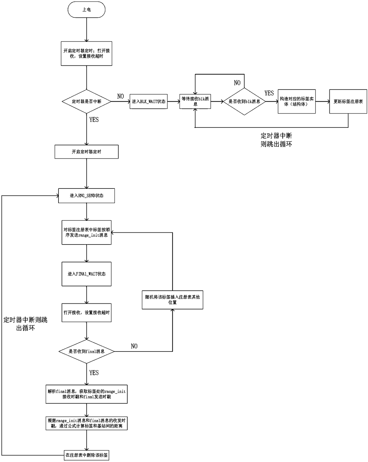
[0050] The present invention will be further described below in conjunction with the accompanying drawings and specific embodiments.

[0051] Such as figure 1 As shown, the base station includes a Cortex-M4 chip, a base station DWM1000 module, a base station serial port module, an LED indicator light, and an Ethernet module. When the base station is working, it supplies power through the serial port module or Ethernet module of the base station, and the LED indicator lights up. The Cortex-M4 chip controls the DWM1000 module of the base station to send and receive signals, and then transmits the position data to the data processing subsystem through the Ethernet module.

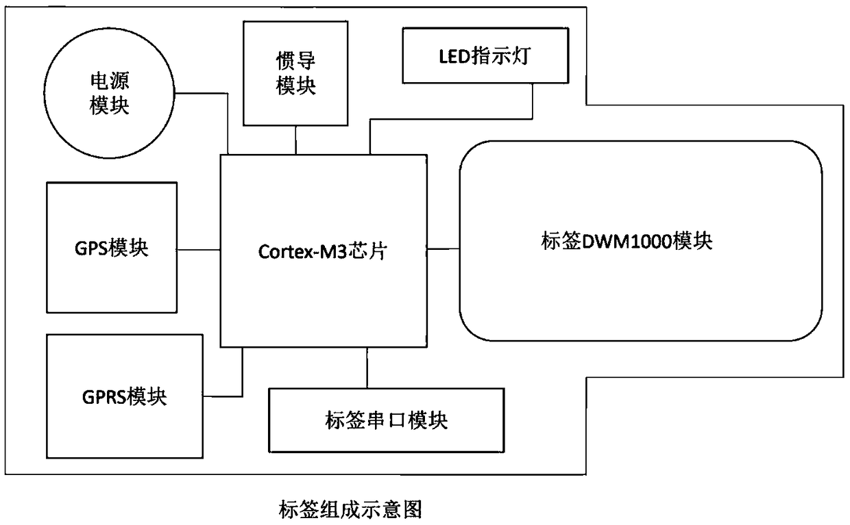
[0052] Such as figure 2 As shown, the tag includes Cortex-M3 chip, tag DWM1000 module, tag serial port module, GPS module, GPRS module, inertial navigation module, power module, LED indicator. When the tag is working, it is powered by the tag’s own power supply, and the LED indicator lights up. When positio...


PUM


Abstract

The invention discloses an indoor and outdoor positioning system and method integrating the GPS and inertial navigation based on the UWB (Ultra Wideband). The indoor and outdoor positioning system iscomposed of a label subsystem, a base station subsystem and a data processing subsystem. Disclosed by the invention is an indoor and outdoor positioning system and method integrating the GPS and inertial navigation based on the UWB, and dynamic accurate positioning and complete data acquisition of a target user in different indoor and outdoor environments are realized by using the UWB technology and inertial navigation. The indoor and outdoor positioning system and method are mainly applied to the Internet of things industry, the tourism industry, business places, airports, fire protection, public security, military, parking lots, hospitals, robots, unmanned aerial vehicles, tunnel mines and the like.

Description

technical field [0001] The invention relates to an indoor and outdoor positioning system based on UWB fusion of GPS and inertial navigation, belonging to the technical field of electronic information. Background technique [0002] The application of navigation and positioning technology has penetrated into various fields of national economy and social development. Outdoor positioning is represented by the Global Navigation Satellite System (GNSS), which has matured and has the advantages of no need to lay transmission lines, fast transmission speed, and no distance restrictions. Therefore, GNSS is more suitable for positioning in relatively open places. With the development of social needs, many industries also put forward urgent needs for indoor positioning technology, such as the Internet of Things industry, tourism industry, commercial places, airports, fire protection, public security, military, parking lots, hospitals, robots, drones, tunnels Mine etc. However, there ...

Claims


Application Information

Patent Timeline
IPC IPC(8): G01S19/49G01C21/16
CPCG01C21/165G01S19/49
Inventor 孙海渤阮爱民黄涛胡航唐健魏刚王智睿姜福康
Owner STATE GRID JIANGSU ELECTRIC POWER CO ZHENJIANG POWER SUPPLY CO
Why Eureka
Try Eureka