Method for positioning and navigation by utilizing all-round looking panoramic imaging

A technology of positioning navigation and panoramic imaging, which is applied in the field of positioning and navigation, can solve the problems of inability to navigate by robots and cannot be applied, and achieve the effect of simple structure, convenient layout, and low cost

Pending Publication Date: 2019-04-23
天津煋鸟科技有限公司
View PDF0 Cites 7 Cited by
  • Summary
  • Abstract
  • Description
  • Claims
  • Application Information

AI Technical Summary

Problems solved by technology

[0003] However, the realization of the above-mentioned purpose needs to rely on radio signals, which is not applicable to some areas without radio signals or in complex electromagnetic environments
In particular, it cannot navigate for robots in some indoor areas, large warehouses, tunnels or residential areas with dense buildings

Method used


Image

  • Method for positioning and navigation by utilizing all-round looking panoramic imaging
  • Method for positioning and navigation by utilizing all-round looking panoramic imaging
  • Method for positioning and navigation by utilizing all-round looking panoramic imaging

Examples


Embodiment Construction

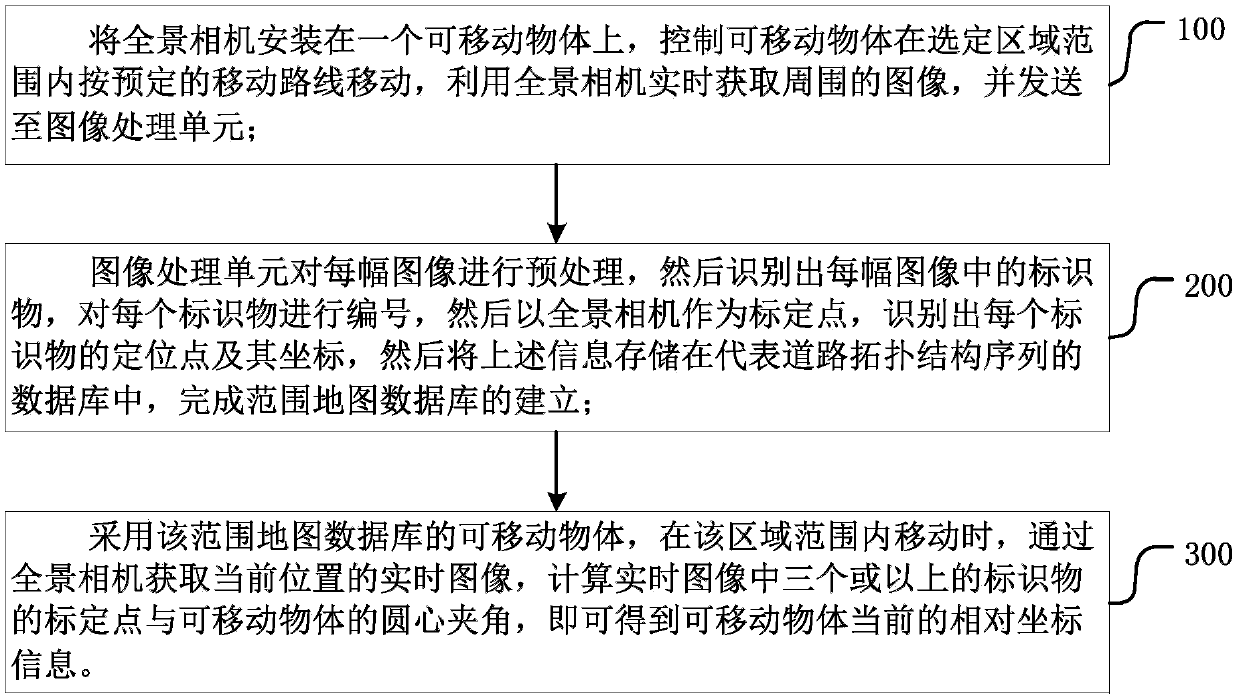
[0026] Such as figure 1 , 2 , 3, an embodiment of the present invention discloses a method for positioning and navigating by using surround-view panoramic imaging, which generally includes the following steps:

[0027] Step 100, installing the panoramic camera on a movable object, controlling the movable object to move within the selected area according to a predetermined movement route, using the panoramic camera to acquire the surrounding images in real time, and sending them to the image processing unit;

[0028] The movable objects here can be any vehicles that can walk, such as robots, cars, bicycles, trolleys, etc. A panoramic camera is a camera that can take a 360-degree shot of the surrounding environment around itself and form an image.

[0029] The predetermined moving route needs to include all roads in the area, that is, the panoramic camera needs to acquire images around all roads in the area.

[0030] The image forming device may be an embedded computer, an AR...


PUM


Abstract

The invention provides a method for positioning and navigation by utilizing all-round looking panoramic imaging. A panoramic camera is utilized to obtain the images of all roads in a selected area range and send the images to an image processing unit. The image processing unit pre-processes the images so as to identify the positioning points and coordinates of markers in each image, the information is stored in a database representing a road topology structure sequence, and thus setting of a range map database is completed; a real-time image of a current position is obtained through the panoramic camera by adopting a movable object of the range map database, the circle center included angle of marking points of three of more markers and the movable object in the real-time image is computed, and the current relative coordinate information of the movable object can be obtained. The method provided by the invention can achieve positioning and navigation without wireless electric signals or under a complex electromagnetic environment, can obtain the self direction or orientation under a static situation, and is an effective supplement to radio positioning navigation systems such as GPSand Beidou.

Description

technical field [0001] The invention relates to the field of positioning and navigation, in particular to a method for establishing a database with markers using images formed by a surround-view panoramic imaging device, so that a movable object using the database can realize walking positioning and navigation. Background technique [0002] Current navigation systems include satellite navigation systems such as GPS and Beidou, which provide users with current location information and action route information in real time through satellites. [0003] However, the realization of the above-mentioned purpose needs to rely on radio signals, which is not applicable to some areas without radio signals or complex electromagnetic environments. In particular, it cannot navigate robots in some indoor areas, large warehouses, tunnels, or residential areas with dense high-rise buildings. Contents of the invention [0004] The purpose of the present invention is to provide a method for...

Claims


Application Information

Patent Timeline
Patent Type & Authority Applications(China)
IPC IPC(8): G01C21/20
CPCG01C21/20
Inventor 张少军
Owner 天津煋鸟科技有限公司
Why Eureka
Try Eureka