Post-event ultra-fast RTK positioning algorithm based on GPS, GLONASS and BDS multiple systems

An ultra-fast, multi-system technology, applied in the field of satellite positioning, can solve problems such as inability to obtain CORS correction data, communication signals cannot be obtained normally, and affect surveying and mapping operations, etc., to eliminate ionospheric delay, satellite clock error, and satellite orbit effect of error

Pending Publication Date: 2019-08-09
广西壮族自治区基础地理信息中心
View PDF6 Cites 11 Cited by
  • Summary
  • Abstract
  • Description
  • Claims
  • Application Information

AI Technical Summary

Problems solved by technology

However, communication signals cannot be obtained normally in some mountainous areas, making it impossible for surveying and mapping professionals working in mountainous areas to obtain stable CORS correction data, which affects normal surveying and mapping operations

Method used


Image

  • Post-event ultra-fast RTK positioning algorithm based on GPS, GLONASS and BDS multiple systems
  • Post-event ultra-fast RTK positioning algorithm based on GPS, GLONASS and BDS multiple systems
  • Post-event ultra-fast RTK positioning algorithm based on GPS, GLONASS and BDS multiple systems

Examples


Embodiment

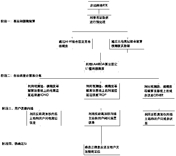
[0079] A post-event ultra-fast RTK positioning method based on GPS, GLONASS and BDS multi-system, comprising the following steps:

[0080] Step 1, use the Melbourne-Wübbena combination to solve the wide-lane ambiguity between the reference stations of GPS, GLONASS and BDS respectively, and then use the results of multiple epochs for smoothing to obtain a reliable wide-lane ambiguity, and then use the direct rounding method to obtain Accurate wide-lane double-differenced integer ambiguity;

[0081] Step 2, using the method of ionospheric delay combination to eliminate the ionospheric delay between reference stations, and solve the ambiguity real number solution; the observation equation is specifically:

[0082]

[0083] Step three, because the ambiguity of the ionosphere-free combination does not have an integer characteristic, the existing ambiguity search method cannot realize the fixation of the ambiguity of the ionosphere-free combination. Using Kalman filtering can co...


PUM


Abstract

The invention discloses a post-event ultra-fast RTK positioning algorithm based on GPS, GLONASS and BDS multiple systems. Firstly, a wide lane ambiguity between reference stations of GPS, GLONASS andBDS is respectively solved by adopting a Melbourne-Wubbena combination, and then ionospheric delay between the reference stations is eliminated by adopting a method without ionospheric delay combination. Double-difference ambiguity float solution and covariance of L1 frequency point can be recovered by using float solution and covariance of fixed wide lane ambiguity and ionosphere-free combined ambiguity, and double-difference integer ambiguity is resovled to calculate atmospheric error, and then atmospheric error interpolation is carried out to generate correction number. GNSS real-time cycleslip detection is carried out, tropospheric errors are corrected, and finally a Kalman filtering parameter estimation method is used to complete new state estimation. The invention is advantageous inthat the high-precision positioning service of CORS can be realized by completing the resolution of the integer ambiguity among the base stations, the extraction of the atmospheric error, the error interpolation, the correction generation, the real-time cycle slip processing, the elimination of the ionospheric delay and the optimization of the tropospheric model, and the algorithm provided by theinvention is convenient for surveying and mapping personnel to obtain stable CORS correction data.

Description

technical field [0001] The invention belongs to the technical field of satellite positioning, and in particular relates to a post-event ultra-fast RTK positioning algorithm based on GPS, GLONASS and BDS multi-systems. Background technique [0002] Compared with conventional RTK technology, network RTK technology has expanded coverage, improved positioning accuracy, reduced operating costs, and reduced user positioning initialization time. It has gradually become the most widely used GNSS precision positioning technology. However, the original GPS single-system network RTK technology is highly restricted by observation conditions. For example, due to the obstruction of buildings or terrain, the number of visible satellites is limited, which makes it impossible for users to obtain high-precision images in areas with severe obstructions such as cities and mountains. Positioning results such that their use is limited under certain spatio-temporal conditions. Today, as the GLONA...

Claims


Application Information

Patent Timeline
Patent Type & Authority Applications(China)
IPC IPC(8): G01S19/33G01S19/29G01S19/44
CPCG01S19/33G01S19/29G01S19/44
Inventor 杨翼飞陈香萍邱小春朱明周聪林钟新颖梁小龙陈宣羽
Owner 广西壮族自治区基础地理信息中心
Why Eureka
Try Eureka