Method for designing MINS/GPS ultra-tight integrated navigation system

A technology for ultra-compact integrated navigation and system design, which is applied in the field of integrated navigation and can solve the problems of large and increased measurement errors, and reduced estimation accuracy of combined filters.

Active Publication Date: 2020-08-25
NORTHWESTERN POLYTECHNICAL UNIV
View PDF7 Cites 9 Cited by
  • Summary
  • Abstract
  • Description
  • Claims
  • Application Information

AI Technical Summary

Problems solved by technology

[0005]The main problem of the SINS/GPS ultra-tight combination system based on SINS-assisted GPS is that if a low-level SINS is used, the When there is interference, the Doppler auxiliary error introduced by SINS will increase rapidly. When the Doppler auxiliary error is large and the tracking loop does not have enough bandwidth margin to track it, the GPS measurement error will be related to the SINS error. This kind of correlation will

Method used


Image

  • Method for designing MINS/GPS ultra-tight integrated navigation system
  • Method for designing MINS/GPS ultra-tight integrated navigation system
  • Method for designing MINS/GPS ultra-tight integrated navigation system

Examples


Embodiment Construction

[0078] The present invention will be further described below in conjunction with the accompanying drawings and embodiments.

[0079] The steps of the technical solution adopted by the present invention to solve the technical problems are:

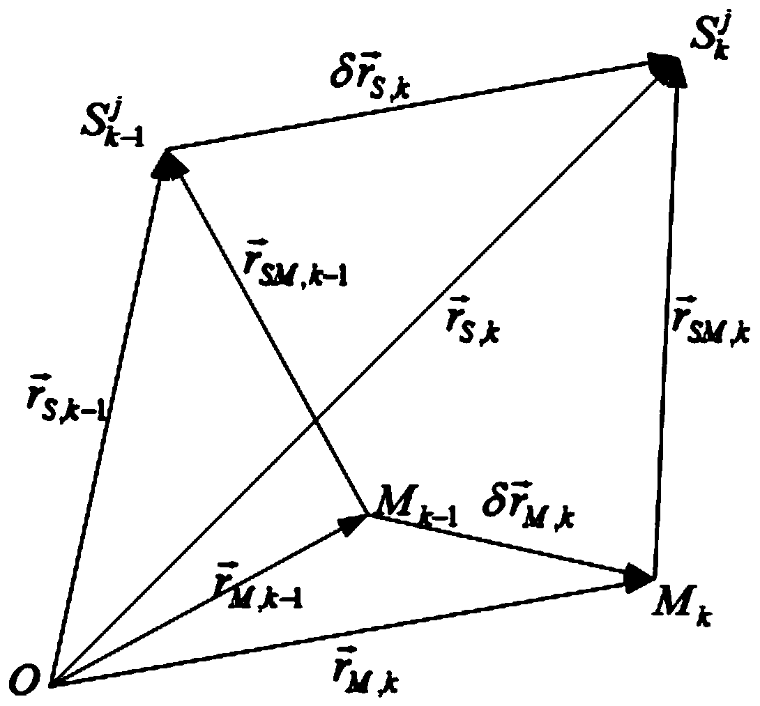
[0080] Step 1: Use the carrier phase measurement output by the GPS receiver to perform time-space difference to obtain the time-space difference carrier phase measurement equation. The specific implementation steps are as shown below. According to the measurement equation, the time- Space differential carrier phase velocity;

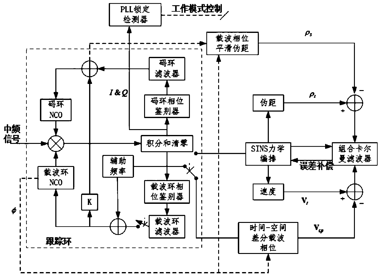
[0081] Step 2: Calculate the Doppler frequency shift using the time-space differential carrier phase velocity obtained in step 1, and assist the GPS carrier tracking loop PLL;

[0082] Step 3: Use the carrier phase measurement of step 1 to smooth the pseudorange output by GPS, and at the same time, Taylor expand the pseudorange obtained from the SINS velocity calculation at the real position of the receiver and retai...


PUM


Abstract

The invention provides a MINS/GPS ultra-tight integrated navigation system design method. The method comprises the following steps of carrying out time-space difference by using carrier phase measurement to obtain a measurement equation, calculating Doppler frequency shift, assisting a GPS carrier tracking loop PLL, smoothing a pseudo-range outputted by a GPS by using carrier phase measurement, and carrying out Taylor expansion of the pseudo-range; and taking the obtained pseudo-range difference and speed difference as measurement of a system model, designing a combined Kalman filter to estimate a system state, correcting inertial device errors and the strapdown inertial navigation calculation navigation information by utilizing a state estimation result outputted by the Kalman filter, andtaking the corrected strapdown inertial navigation calculation information as the navigation positioning result. The method is advantaged in that the Doppler auxiliary errors caused by low-precisionSINS are avoided, correlation between GPS measurement errors and SINS speed errors is avoided, dynamic performance, the anti-interference capability and the navigation positioning precision of the system are enhanced, and non-linear errors introduced by linear pseudo-range measurement are overcome.

Description

technical field [0001] The invention relates to the technical field of combined navigation, in particular to a design method of MINS / GPS ultra-tight combination. Background technique [0002] Global Positioning System (GPS) and Strapdown Inertial Navigation System (SINS) are highly complementary. The SINS / GPS integrated navigation system has the advantages of both systems, and can overcome the shortcomings of each system at the same time. It is one of the main forms of integrated navigation technology at present and plays a very important role in aviation, space navigation and weapon guidance. Compared with the SINS / GPS loose and tight integrated navigation system, the SINS / GPS ultra-tight integrated navigation system adds assistance to the GPS receiver, has higher dynamic performance and anti-interference ability, and is gradually becoming the first choice of SINS / GPS integrated navigation. The main research direction. [0003] According to the different implementation fo...

Claims


Application Information

Patent Timeline
IPC IPC(8): G01S19/47G01S19/43G01C21/16
CPCG01S19/47G01S19/43G01C21/165
Inventor 任建新自俊林谢斌管宏旸
Owner NORTHWESTERN POLYTECHNICAL UNIV
Why Eureka
Try Eureka