Unmanned aerial vehicle navigation map construction system and method based on image three-dimensional reconstruction technology

A navigation map and three-dimensional reconstruction technology, applied in the field of three-dimensional reconstruction, can solve problems such as difficulty in obtaining three-dimensional spatial maps, and achieve the effects of fast reconstruction speed, reduced time consumption, and high map accuracy

Active Publication Date: 2020-08-28
STAR (CHONGQING) INTELLIGENT EQUIP TECH RES INST CO LTD
View PDF8 Cites 14 Cited by
  • Summary
  • Abstract
  • Description
  • Claims
  • Application Information

AI Technical Summary

Problems solved by technology

Generally speaking, it is difficult to obtain a high-precision 3D space map that can be used for navigation, so it is necessary to find a convenient method to obtain a 3D navigation map of the scene
The 3D navigation map of the scene can provide important auxiliary information for UAV navigation tasks such as path planning or obstacle avoidance, but there is no such method to obtain the 3D navigation map of the scene, so it needs to overcome

Method used


Image

  • Unmanned aerial vehicle navigation map construction system and method based on image three-dimensional reconstruction technology
  • Unmanned aerial vehicle navigation map construction system and method based on image three-dimensional reconstruction technology
  • Unmanned aerial vehicle navigation map construction system and method based on image three-dimensional reconstruction technology

Examples


Embodiment 1

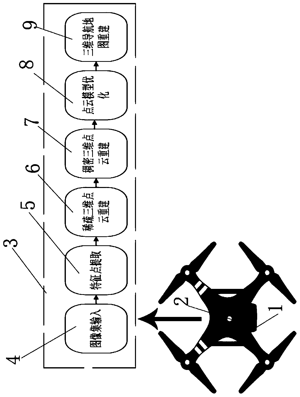
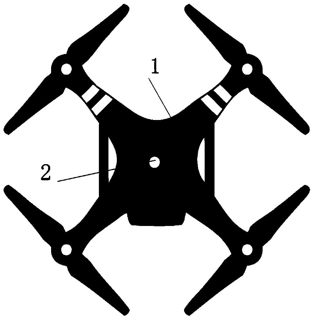
[0057] see figure 1 , figure 2 , this embodiment discloses a UAV navigation map construction system based on image three-dimensional reconstruction technology, including a UAV 1, a data collection component 2 and a three-dimensional navigation map construction system 3; the data collection component 2 is set in an unmanned On the machine 1, the data acquisition component 2 is a camera; the camera is used to collect the image set of the scene; the three-dimensional navigation map construction system 3 includes an image set input system 4, a feature point extraction system 5, and a sparse three-dimensional point cloud reconstruction system 6. A dense three-dimensional point cloud reconstruction system 7, a point cloud model optimization system 8 and a three-dimensional navigation map reconstruction system 9; the image set input system 4 is to input the scene image set into the three-dimensional navigation map construction system, and the features The point extraction system 5...

Embodiment 2

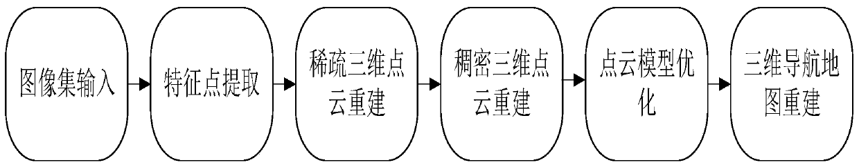
[0067] Such as Figure 3-7 As shown, this embodiment discloses a method for constructing a UAV navigation map based on image three-dimensional reconstruction technology, which specifically includes the following steps:

[0068] S1, for constructing a three-dimensional navigation map for the scene image set collected by the data collection component 2;

[0069] S2. Input the collected scene image set into the 3D navigation map construction system, and sequentially perform feature point extraction, sparse 3D point cloud reconstruction, dense 3D point cloud reconstruction, point cloud model optimization and 3D point cloud reconstruction in the 3D navigation map construction system. After the navigation map is reconstructed, the three-dimensional navigation map of the scene is finally obtained as the navigation assistance information for the UAV 1 .

[0070] As a preference, the specific method for constructing a three-dimensional navigation map for the scene image set collected ...


PUM


Abstract

The invention relates to an unmanned aerial vehicle navigation map construction system based on an image three-dimensional reconstruction technology. The unmanned aerial vehicle navigation map construction system comprises an unmanned aerial vehicle, a data acquisition assembly and a three-dimensional navigation map construction system, wherein the three-dimensional navigation map construction system comprises an image set input system, a feature point extraction system, a sparse three-dimensional point cloud reconstruction system, a dense three-dimensional point cloud reconstruction system, apoint cloud model optimization system and a three-dimensional navigation map reconstruction system. A scene image set is input into a three-dimensional navigation map construction system, feature point detection is carried out on all images, and a sparse point cloud model of a scene and a dense point cloud model of the scene are reconstructed, and then miscellaneous points of the models are removed, and surface reconstruction is carried out, and optimization is carried out, and a three-dimensional navigation map of the scene is reconstructed. The invention further discloses an unmanned aerialvehicle navigation map construction method based on the image three-dimensional reconstruction technology. According to the unmanned aerial vehicle navigation map construction method, the three-dimensional navigation map is constructed by utilizing the system, and the reconstructed three-dimensional navigation map is close to a real scene, and the precision is relatively high.

Description

technical field [0001] The invention relates to the technical field of three-dimensional reconstruction, in particular to a system and method for constructing a UAV navigation map based on image three-dimensional reconstruction technology. Background technique [0002] Vision is the most important way humans perceive their surroundings. Enabling computers to perceive three-dimensional environments like humans is a very popular research direction in the field of computer vision. With the rapid development of information technology, virtual reality, movie special effects, intelligent driving, robot navigation, geographic maps, history and culture, medicine and many other fields require 3D models. For example, high-precision maps in autonomous driving are a prerequisite for autonomous driving. In the early stages, large-scale collection of urban road-related data is used to reconstruct high-precision maps through 3D; mobile robots use 3D occupancy maps for navigation, such as ...

Claims


Application Information

Patent Timeline
Patent Type & Authority Applications(China)
IPC IPC(8): G06T17/00G01C21/00
CPCG06T17/00G01C21/005G06T7/50G05D1/102G01C23/00G01C21/3804Y02T10/40G06T17/05G06T2210/61
Inventor 宋永端曹枭
Owner STAR (CHONGQING) INTELLIGENT EQUIP TECH RES INST CO LTD
Why Eureka
Try Eureka