Flood coverage extraction method based on remote sensing image

A remote sensing image and extraction method technology, applied in the field of remote sensing applications, can solve the problems of inability to obtain accurate flood areas, etc., and achieve the effect of clear and intuitive algorithm thinking, accurate range of flood areas, and high portability

Active Publication Date: 2021-04-23
WUHAN UNIV
View PDF5 Cites 4 Cited by
  • Summary
  • Abstract
  • Description
  • Claims
  • Application Information

AI Technical Summary

Problems solved by technology

[0006] It can be seen that neither optical remote sensing data nor radar remote sensing data alone can obtain the flood area with high accuracy. Therefore, how to extract the flood coverage area more accurately is the focus of current research

Method used


Image

  • Flood coverage extraction method based on remote sensing image
  • Flood coverage extraction method based on remote sensing image
  • Flood coverage extraction method based on remote sensing image

Examples


Embodiment Construction

[0041]The technical solutions in the embodiments of the present invention will be described below in conjunction with the embodiments of the present invention, and clearly, the described embodiments are merely embodiments of the invention, not all of the embodiments. Based on the embodiments in the present invention, all other embodiments obtained in the art without creative labor are not made in the premise of creative labor.

[0042]It should be noted that the features in the present invention in the present invention can be combined with each other in the case of an unable conflict.

[0043]The present invention will be further described below in connection with the specific embodiments, but is not limited as the present invention.

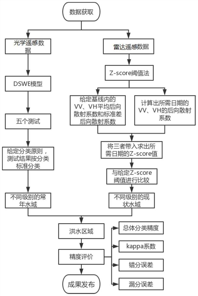
[0044]The present invention provides an extraction method of a flood coverage of remote sensing images, including the following steps:

[0045]S1: Get the LANDSAT-8 terrestrial satellite optical remote sensing image data, calculate its historical water distribut...


PUM


Abstract

The invention provides a flood coverage extraction method based on a remote sensing image, and the method comprises the following steps: S1, obtaining land satellite optical remote sensing image data, calculating the historical water body distribution probability, and obtaining a perennial water area range distribution map through setting a distribution probability threshold value; s2, acquiring satellite radar remote sensing image data, calculating statistical information of each pixel time domain within a set time range, and calculating a current water area distribution diagram by adopting a statistical threshold method; and S3, classifying the flood coverage types in combination with the perennial water area and the current water area range, and extracting the flood coverage ranges of different levels at present. The flood coverage range is extracted by combining historical and current water distribution, and the current flood coverage range can be rapidly and accurately obtained.

Description

Technical field[0001]The present invention belongs to the technical field of remote sensing applications, and in particular, a method of extracting a remote sensing image flood coverage based on a water distribution rate and a statistical threshold.Background technique[0002]As the world's most frequent natural disasters, floods seriously threaten people's lives and property. Therefore, in order to quickly analyze the disaster, rapid extraction for sudden flood information is necessary. Satellite remote sensing images have been an important means of monitoring surface information in recent years, and there is a great advantage in extracting water.[0003]Remote sensing data commonly used in large-scale floods includes optical and radar remote sensing data. The optical remote sensing data is large, high resolution, has a wide range of research in terms of extracting waters, but it is easy to mix with cloud shadow status in the extraction water. The radar remote sensing is a microwave th...

Claims


Application Information

Patent Timeline
Patent Type & Authority Applications(China)
IPC IPC(8): G06T7/00G06T7/136G06T7/62G01S7/41
CPCG06T7/0002G06T7/136G06T7/62G01S7/41G06T2207/10032G06T2207/30181
Inventor 黄文丽冯梅陈淑杰
Owner WUHAN UNIV
Why Eureka
Try Eureka