Enhanced airport mobile map device based on data chain

A data link and enhanced technology, applied in the field of data processing in the civil aviation domain, can solve problems such as the inability to digitize control instructions and the superimposition of taxi-related auxiliary information, and achieve the effects of reducing operational risks on the ground, enhancing situational awareness, and improving taxiing efficiency

Pending Publication Date: 2021-07-30
AVIATION DATA COMM
View PDF0 Cites 2 Cited by
  • Summary
  • Abstract
  • Description
  • Claims
  • Application Information

AI Technical Summary

Problems solved by technology

However, this kind of airport mobile map is static, and it is impossible to graphically superimpose various digital control instructions and taxi-related auxiliary information required by the crew on the airport mobile map terminal

Method used


Image

  • Enhanced airport mobile map device based on data chain

Examples


Embodiment Construction

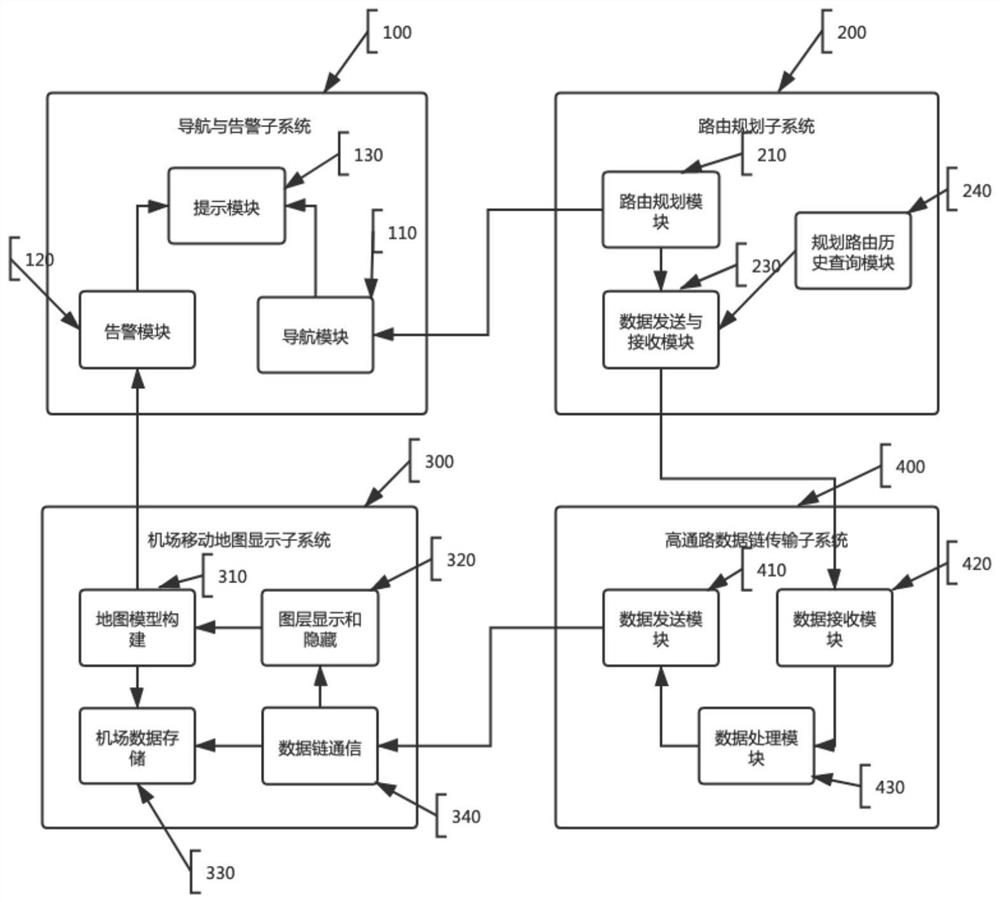
[0011] In order to make the object, technical solution and advantages of the present invention clearer, the present invention will be further described in detail below in conjunction with the accompanying drawings and specific embodiments. It should be understood that the specific embodiments described here are only used to explain the present invention, not to limit the present invention.

[0012] In order to make the description of the present disclosure more detailed and complete, the following provides an illustrative description of the implementation modes and specific examples of the present invention; but this is not the only form for implementing or using the specific embodiments of the present invention. The description covers the features of various embodiments as well as the steps and sequences of apparatus steps for constructing and operating these embodiments. However, other embodiments can also be used to achieve the same or equivalent functions and step sequence...


PUM


Abstract

An enhanced airport mobile map device based on the data link comprises a mobile map display subsystem which is configured to graphically display an airport scene environment, overlay scene aircraft and vehicle operation situations and provide scene taxiing navigation; a data link communication subsystem, which is configured to provide a data link communication link, realize digital control instruction, sliding related auxiliary information and scene situation transmission and push the information to a specified aircraft as required; a route planning subsystem, which is configured to complete superposition display of airport scene routes and can provide voice and character navigation prompts in real time according to the current position of the unit; a navigation and alarm subsystem, which is configured to provide an efficient sliding guide service for the scene unit based on the planning routing subsystem, and give an alarm prompt to a restricted area, a conflict hot spot area, an obstacle or other aircrafts within a certain range nearby according to the current positioning and sliding speed.

Description

technical field [0001] The present invention relates to the technical field of civil aviation data processing, in particular to an enhanced airport mobile map device based on a data link, which realizes real-time acquisition of flight task-related auxiliary information and digital control instructions based on the data link, and based on the enhanced airport mobile map. The instructions are graphically overlaid. Background technique [0002] In recent years, with the sustained and rapid development of my country's aviation industry, as well as the rapid growth of air transportation volume and transportation turnover, the scene environment of large airports is complex and the traffic business is busy. The traditional method of using paper airport maps to understand the scene environment has become difficult. Meet the management requirements of modern airports. [0003] The airport mobile map can provide pilots with an airport electronic map containing their own coordinates, r...

Claims


Application Information

Patent Timeline
Patent Type & Authority Applications(China)
IPC IPC(8): G06F16/29
CPCG06F16/29
Inventor 朱衍波李方闻唐晔旸刘凯刘彦利熊申东杨亚坤巩燕
Owner AVIATION DATA COMM
Why Eureka
Try Eureka