Method and apparatus for transmitting position information on a digital map
Inactive Publication Date: 2008-04-01
PANASONIC INTELLECTUAL PROPERTY CORP OF AMERICA
View PDF86 Cites 27 Cited by
Summary
Abstract
Description
Claims
Application Information
AI Technical Summary
This helps you quickly interpret patents by identifying the three key elements:
Problems solved by technology
Method used
Benefits of technology
Benefits of technology
[0015]The invention solves such related art problems and aims at providing a position information transmission method for accurately transmitting a position and a shape on a digital map using a small amount of data and apparatus for implementing the method.
[0020]This makes it possible to transmit event positions on a digital map efficiently and accurately with a small data amount thus enhancing the data transmission efficiency.
Problems solved by technology
In the system where road shape data is transmitted, however, how to reduce the transmission data amount without degrading the information accuracy is a major problem.
In case, as shown in FIG. 23, the road density is low but the road shape is complicated and an interval between nodes is longer, as on the roads in the mountains, using such a system still requires a large amount of data to represent the road shape.
Method used
Image
Click on the blue label to locate the original text in one second.
Reading with bidirectional positioning of images and text.
Examples
first embodiment
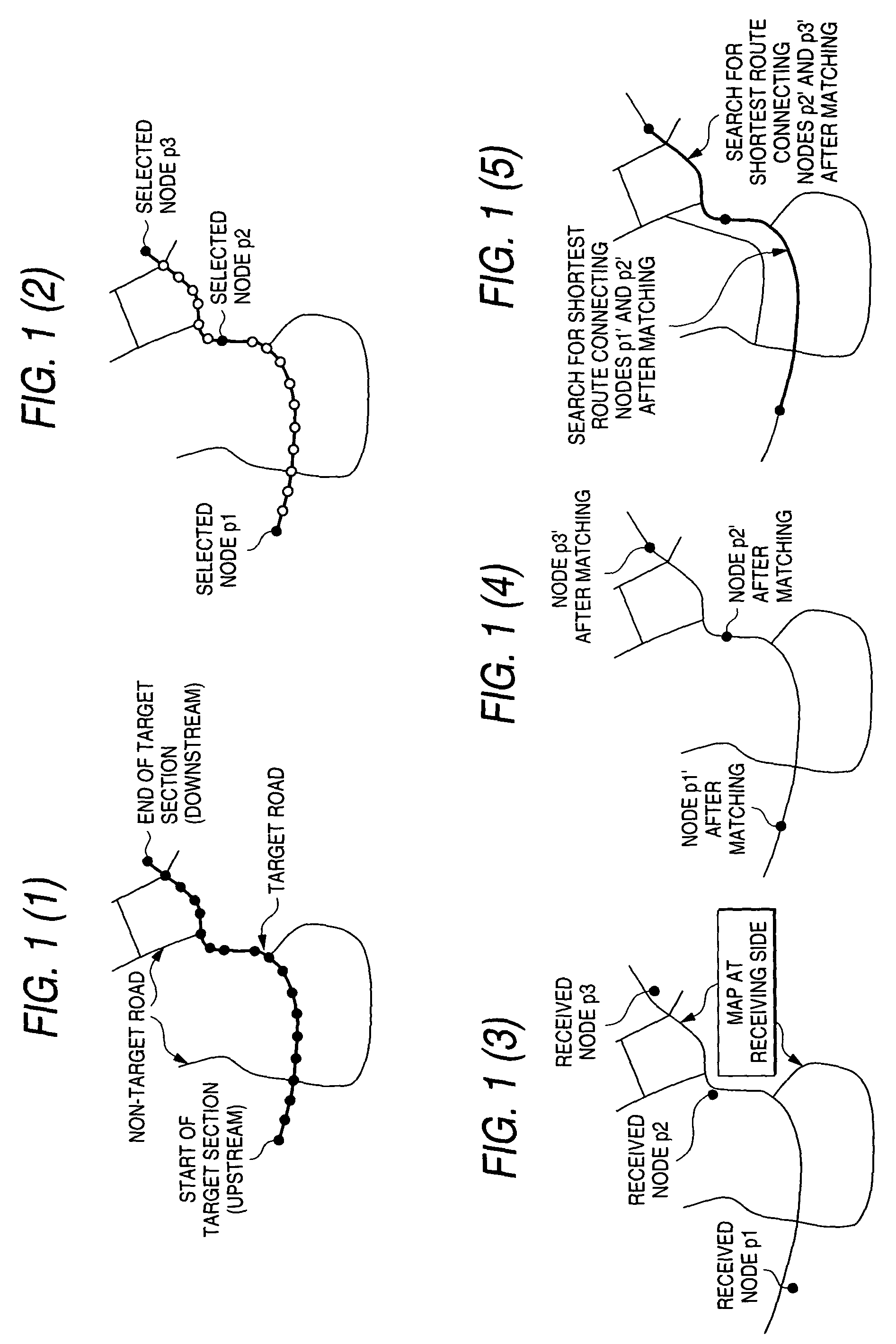
[0045]According to a position information transmission method of the invention, a transmitting side selects a small number of nodes (which may be two points, start point and end point) out of the nodes included in a road section to be transmitted, and transmits the node information. A receiving side performs a map matching to determine the positions of the received nodes and sequentially searches for the shortest routes connecting the nodes, then links the shortest routes to identify the road section.
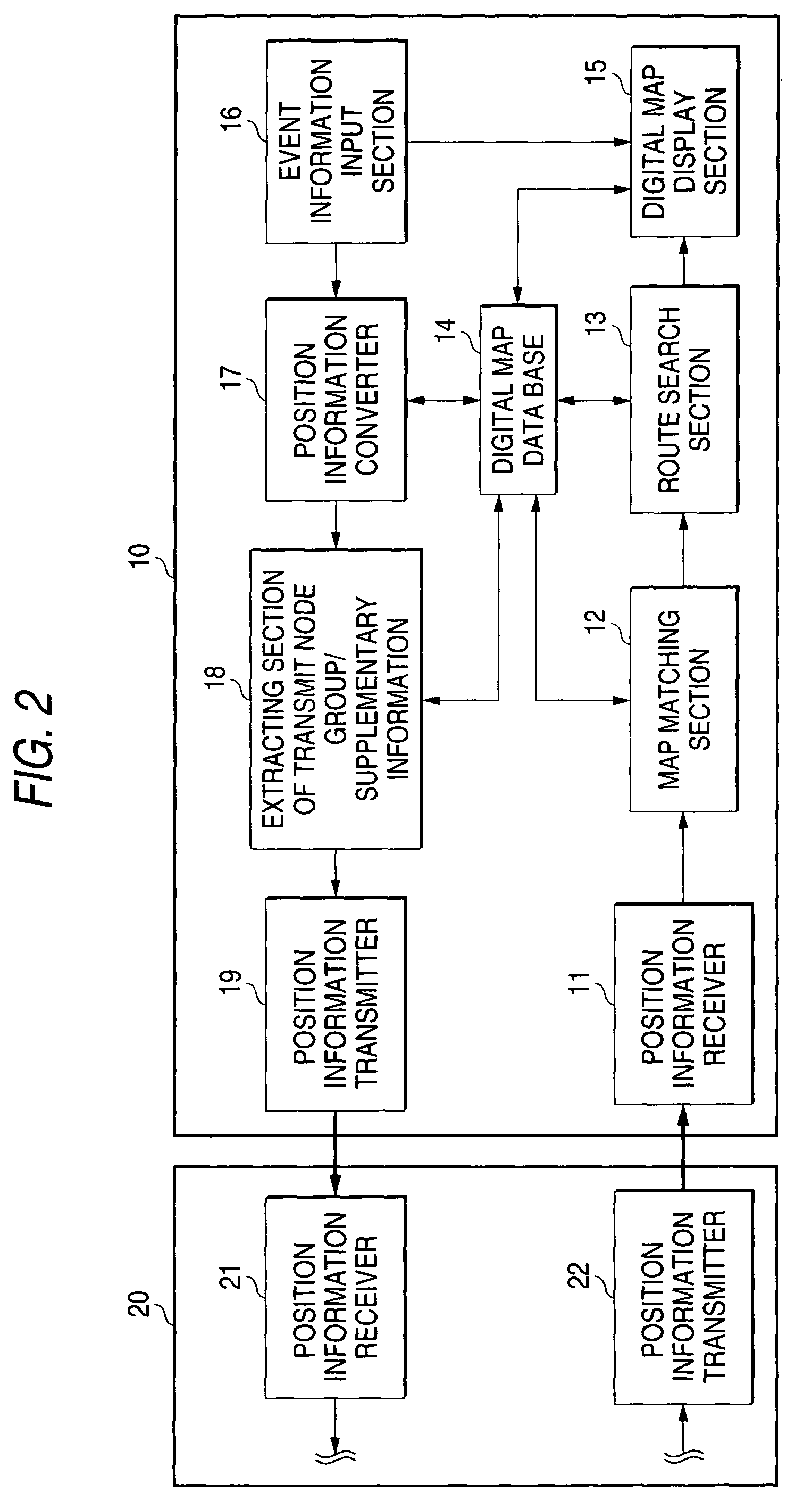
[0046]FIG. 2 shows the configuration of the position information transmission / receiving apparatus 10 that exchanges event information occurring in the jurisdiction with other apparatus 20.
[0047]The apparatus 10 includes a position information receiver 11 for receiving position information sent from the position information transmitter 22 of the other apparatus 20, a digital map database 14 for accumulating digital map data, a map matching section 12 for identifying the corresponding nod...
second embodiment
[0070]The second embodiment explains a method for including as supplementary information the intercept azimuth information in the node position in the shape vector data string information in order to enhance the matching accuracy at the receiving side in implementing a position information transmission method of the first embodiment.
[0071]The intercept azimuth in the node position is the azimuth of a tangent to the road curve at the node px as shown by the arrow of a dotted line in FIG. 8, and displayed clockwise within the range of 0 to 360 degrees, assuming the absolute azimuth of the true north as 0 degrees. The intercept azimuth of the node px is obtained by averaging the azimuth θx−1 of a line connecting the node px−1 and the node px−1 and the azimuth θx of a straight line connecting the node px and the node px+1 where px−1 is an upstream node adjacent to the node px and px+1 is a downstream node adjacent to the node px as shown in FIG. 10:
(θx−1+θx) / 2 (Formula 1)
[0072]FIG. 11 ...
third embodiment
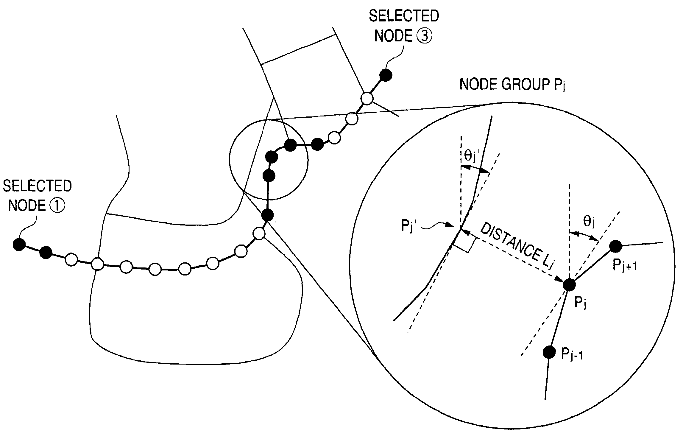
[0084]The third embodiment explains a method for increasing the number of transmit nodes at road points where the receiving side is likely to commit erroneous matching thus enhancing the matching accuracy at the receiving side in implementing a position information transmission method of the first embodiment.
[0085]FIGS. 14(1), (2), (3), (4), and (5) are schematic views of the processing details in the position information transmission method on the map.
[0086]The transmitting side, as shown in FIG. 14(1), selects a target road section, then the nodes to be transmitted out of the nodes in the target road section. In this practice, the transmitting side selects a plurality of nodes (node group) for easy identification of the different shape of the adjacent road at sections, where the receiving side is likely to commit erroneous matching due to presence of an adjacent road, which is parallel to the target road.
[0087]The transmitting side transmits shape vector data string information co...
PUM
Abstract
The invention purposes to provide a position information transmission method for accurately transmitting a position and a shape on a digital map with a small amount of data.In a position information transmission method of the invention, the transmitting side transmits road shape information to specify the target road section on a digital map and event information to specify an event position by using a relative position in the target road section and the receiving side performs map matching based on the road shape information to identify the target road section and identifies the event position in the target road section based on the event information is characterized in that the transmitting side intermittently selects nodes included in the target road section to include the coordinate data of the nodes in the road shape information for transmission, and that the receiving side performs map matching to determine the positions of the nodes included in the road shape information and obtains the road connecting the nodes by way of a route search to identify the target road section. It is thus possible to efficiently and accurately transmit an event position on a digital map.
Description
[0001]This patent application is a continuation of U.S. Ser. No. 10 / 169,639 filed Jul. 3, 2002, now U.S. Pat. No. 6,662,101 which is a 371 of PCT / JP02 / 00601 filed Jan. 28, 2002.TECHNICAL FIELD[0002]The present invention relates to a method for transmitting position information on a digital map and apparatus for implementing the method, and in particular to a method and apparatus for accurately transmitting position information on a digital map by using only a small amount of data.BACKGROUND OF THE INVENTION[0003]In recent years, the number of vehicles that have on-board navigation apparatus has been increasing rapidly. The on-board navigation apparatus maintains a digital map database and is capable of displaying traffic congestion and traffic accident positions on the map based on traffic congestion information and traffic accident information provided by a traffic information center as well as performing a route search using conditions including the aforementioned information.[000...
Claims
Application Information
Patent Timeline
Application Date:The date an application was filed.
Publication Date:The date a patent or application was officially published.
First Publication Date:The earliest publication date of a patent with the same application number.
Issue Date:Publication date of the patent grant document.
PCT Entry Date:The Entry date of PCT National Phase.
Estimated Expiry Date:The statutory expiry date of a patent right according to the Patent Law, and it is the longest term of protection that the patent right can achieve without the termination of the patent right due to other reasons(Term extension factor has been taken into account ).
Invalid Date:Actual expiry date is based on effective date or publication date of legal transaction data of invalid patent.

