Estimation method and system of vehicle traveling overhead

A vehicle and overhead technology, applied in computing, instrumentation, electrical digital data processing, etc., can solve the problems of consuming computing resources and difficulty in road vehicle estimation, and achieve the effect of overcoming the problem of data sparsity and avoiding the consumption of computing resources

Active Publication Date: 2014-12-03
GUANGZHOU HKUST FOK YING TUNG RES INST
View PDF4 Cites 6 Cited by
  • Summary
  • Abstract
  • Description
  • Claims
  • Application Information

AI Technical Summary

Problems solved by technology

On the other hand, because the specific information is speculated based on the overall traffic vehicle trajectory information, continuous iteration in the method of using machine learning will consume a lot of computing resources
Therefore, this method is difficult to estimate the road vehicle travel cost under the actual massive traffic data in the real world.

Method used


Image

  • Estimation method and system of vehicle traveling overhead
  • Estimation method and system of vehicle traveling overhead
  • Estimation method and system of vehicle traveling overhead

Examples


Embodiment 1

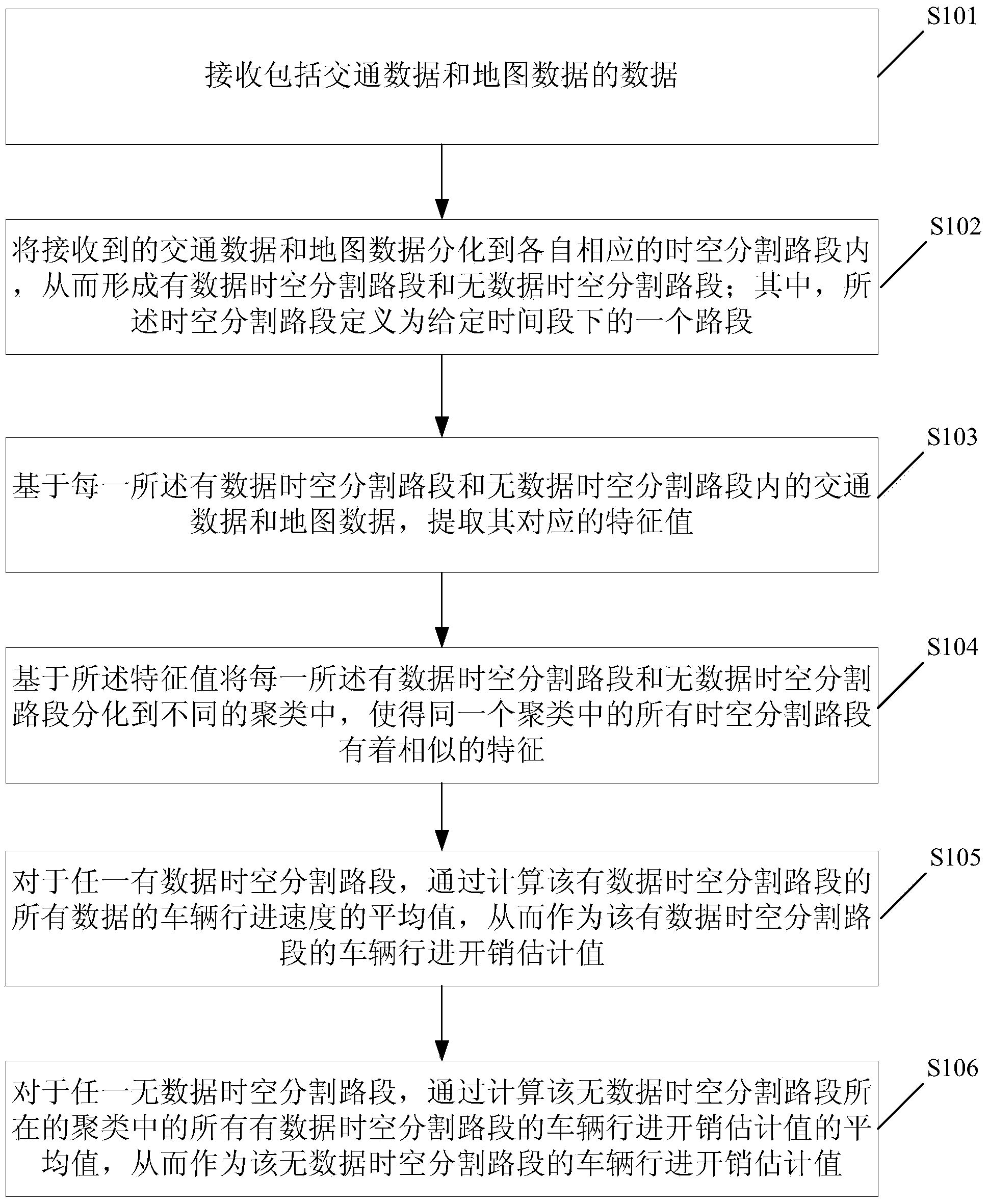
[0042] see figure 1 , is a schematic flowchart of a method for estimating vehicle travel costs provided by an embodiment of the present invention, including steps:

[0043] S101. Receive data including traffic data and map data;

[0044] Wherein, the traffic data includes at least current time information, location longitude information and travel speed information of the vehicle at different time points, and the map data includes start and end latitude and longitude information of road sections.

[0045] S102. Divide the received traffic data and map data into respective corresponding time-space segmented road sections, thereby forming a time-space segmented road segment with data and a time-space segmented road segment without data; wherein, the time-space segmented road segment is defined as a road segment under a given time period a section;

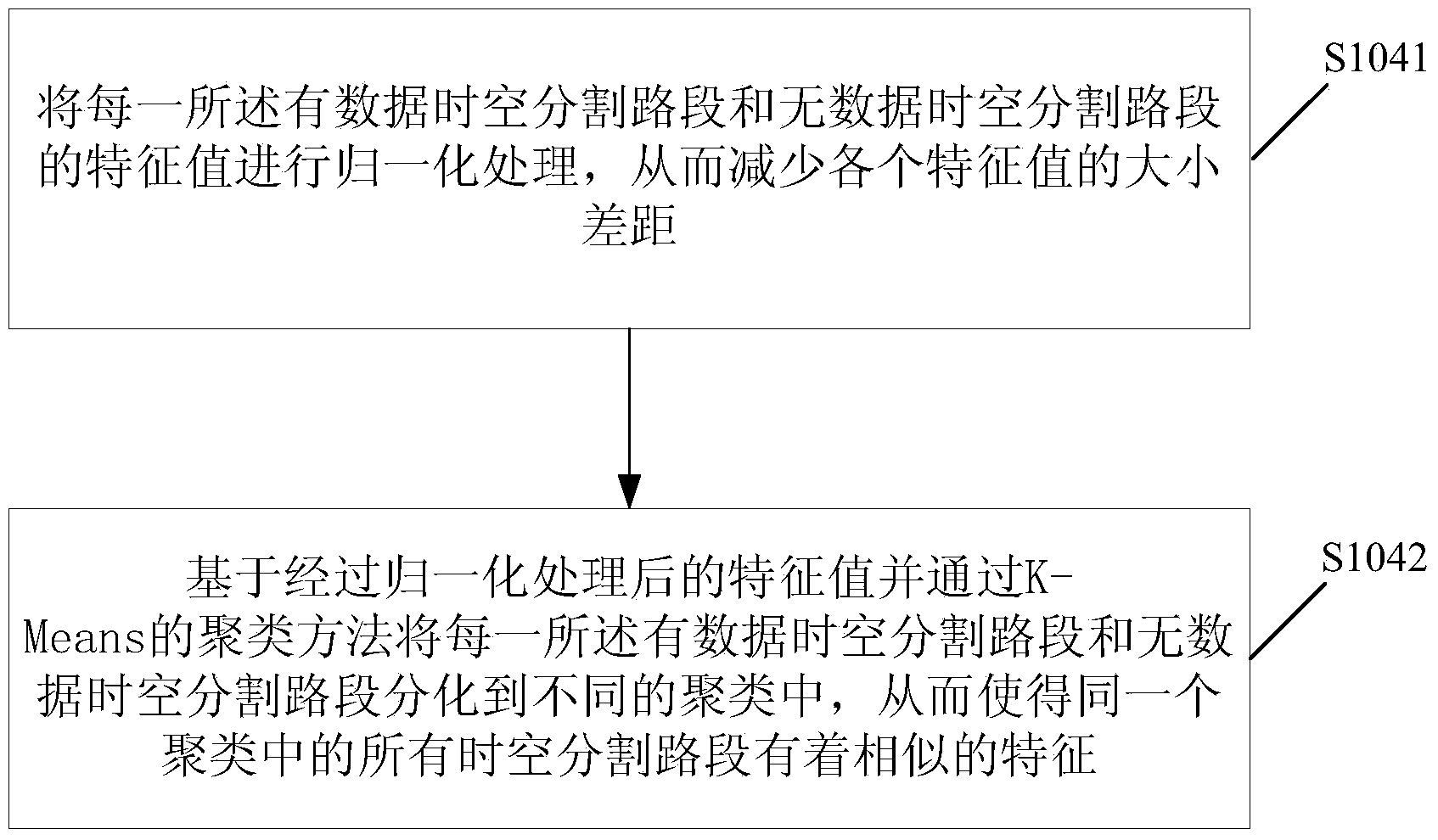
[0046] S103. Based on the traffic data and map data in each of the time-space segmentation road sections with data and the time-s...

Embodiment 2

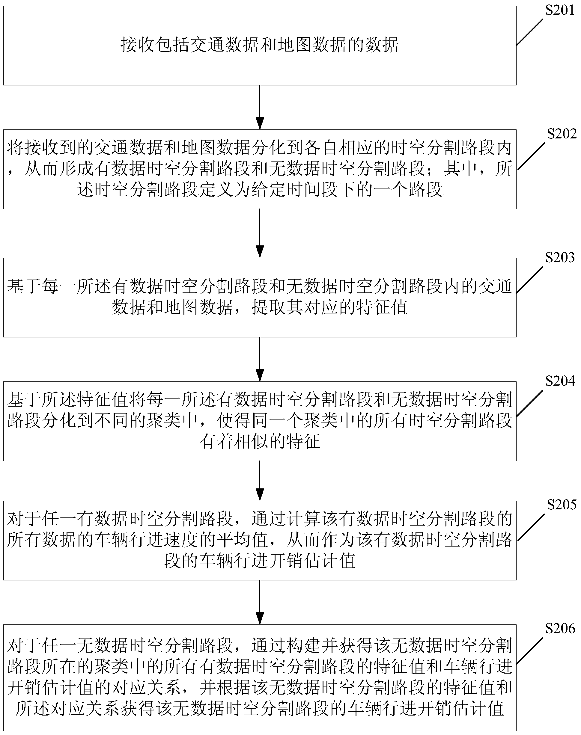
[0077] see image 3 , is a schematic flowchart of a method for estimating vehicle travel costs provided by an embodiment of the present invention, including steps:

[0078] S201. Receive data including traffic data and map data;

[0079] Wherein, the traffic data includes at least current time information, location longitude information and travel speed information of the vehicle at different time points, and the map data includes start and end latitude and longitude information of road sections.

[0080] S202. Divide the received traffic data and map data into corresponding time-space segmented road sections, thereby forming time-space segmented road segments with data and time-space segmented road segments without data; wherein, the time-space segmented road segments are defined as road segments under a given time period a section;

[0081] S203. Based on the traffic data and map data in each of the time-space segmentation road sections with data and without data space-tim...

Embodiment 3

[0101] see Figure 5 , is a schematic structural diagram of a system for estimating vehicle travel expenses provided by an embodiment of the present invention, including:

[0102] The data input unit 301 is configured to receive data including traffic data and map data; wherein, the traffic data includes at least current time information, position longitude information, and travel speed information of the vehicle at different time points, and the map data includes the start and end of road sections. Always stop latitude and longitude information.

[0103] The time-space segmentation road section differentiation unit 302 is used to differentiate the received traffic data and map data into respective corresponding time-space segmentation road sections, thereby forming a time-space segmentation road section with data and a time-space segmentation road section without data; wherein, the time-space segmentation road section defines is a road segment under a given time period;

[...


PUM


Abstract

The invention discloses an estimation method of vehicle traveling overhead. The method comprises the steps that received traffic data and received map data are differentiated to corresponding space-time segmentation road segments respectively so that the space-time segmentation road segments with data and the space-time segmentation road segments without data can be formed, and characteristic values corresponding to the space-time segmentation road segments with data and the space-time segmentation road segments without data are extracted respectively; all the space-time segmentation road segments with data and all the space-time segmentation road segments without data are differentiated to different clusters on the basis of the characteristic values, so that all the space-time segmentation road segments in the same cluster have similar characteristics; the average value of vehicle traveling speeds of all the data in any space-time segmentation road segment with data is calculated to serve as a vehicle traveling overhead estimated value of the space-time segmentation road segment with data; the average value of vehicle traveling overhead estimated values of all the space-time segmentation road segments with data in the cluster where any space-time segmentation road segment without data is located is calculated to serve as a vehicle traveling overhead estimated value of the space-time segmentation road segment without data. The invention further discloses an estimation system of vehicle traveling overhead.

Description

technical field [0001] The invention relates to the field of traffic data processing, in particular to a method and system for estimating vehicle travel expenses. Background technique [0002] With the development of technology, more and more traffic data can be collected and utilized by people. For example, with the popularization of GPS devices, taxis in metropolitan cities are equipped with GPS devices. Through these devices and other related vehicle information collection devices, taxis can continuously transmit their location information, speed information, and passenger information to the data center. As a result, the data center can collect massive amounts of traffic data to perform a series of data mining and analysis tasks. Due to the rich value of massive traffic data, the mining work based on traffic data has become a hot and active research field. Research work related to traffic data mainly contains two purposes. One is to discover some dynamic characteristi...

Claims


Application Information

Patent Timeline
Patent Type & Authority Applications(China)
IPC IPC(8): G08G1/01G06F17/30
Inventor 叶子豪高民谭浩宇
Owner GUANGZHOU HKUST FOK YING TUNG RES INST
Why Eureka
Try Eureka